Modimolle
| Modimolle | |
|---|---|
 Modimolle  Modimolle  Modimolle
| |
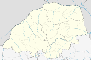
| Coordinates: 24°42′00″S 28°24′22″E / 24.70000°S 28.40611°ECoordinates: 24°42′00″S 28°24′22″E / 24.70000°S 28.40611°E | |
| Country | South Africa |
| Province | Limpopo |
| District | Waterberg |
| Municipality | Modimolle |
| Area[1] | |
| • Total | 83.3 km2 (32.2 sq mi) |
| Population (2011)[1] | |
| • Total | 41,988 |
| • Density | 500/km2 (1,300/sq mi) |
| Racial makeup (2011)[1] | |
| • Black African | 87.5% |
| • Coloured | 0.5% |
| • Indian/Asian | 0.5% |
| • White | 11.3% |
| • Other | 0.3% |
| First languages (2011)[1] | |
| • Northern Sotho | 62.2% |
| • Afrikaans | 11.1% |
| • Tsonga | 9.7% |
| • Tswana | 4.8% |
| • Other | 12.2% |
| Postal code (street) | 0510 |
| PO box | 0510 |
| Area code | 014 |
Modimolle is a town located near the southern edge of the Waterberg Massif in Limpopo province, South Africa. It is a medium-sized town that focuses primarily on agriculture and farming (citrus, grapes and cattle) as well as wildlife and tourism. Modimolle is also located approximately 135 kilometres (84 miles) north of Pretoria, South Africa's de facto capital city.
The Waterberg Biosphere spreading north, a UNESCO designated Biosphere Reserve, contains approximately 15,000 square kilometres (5,792 square miles). Waterberg is the first region in the northern part of South Africa to be named as a Biosphere Reserve by UNESCO. The extensive rock formation was shaped by hundreds of millions of years of riverine erosion to yield diverse bluff and butte landform.[2] The ecosystem can be characterised as a dry deciduous forest or Bushveld.
History
In the 1860s, a group of Voortrekkers known as the Jerusalem Trekkers set off for the Holy Land. After discovering a wide river flowing northwards, they consulted the maps at the back of their Bibles and decided that it was the Nylrivier (Nile river).[3] They called the stream Nyl River and settled the town and called it Nylstroom in 1866.[4][5] After discovering what they believed to be a ruined pyramid, they were convinced that they had found the Nile. It was in fact, a natural hillock, known to the locals as Modimolle.[6] In March 1866, the district of Waterberg was created out of some of the districts of Rustenburg and Zoutpansberg with a landdrost established in Nylstroom.[7]:230 A Dutch Reformed Church was built in 1889 and is the oldest church in sub-saharan Africa north of Pretoria. It was also used as a hospital during the Second Boer War. The river is the Nyl River, a tributary of the Mogalakwena River.
The first railway line reached Nylstroom in 1898, connecting the town to Pretoria. During the Second Boer War, the British operated a concentration camp in Nylstroom, where Boer women and children where interned as part of the British Scorched Earth policy. This subsequently led to the loss of 544 lives at the Nylstroom concentration camp. Strijdom Huis (Strijdom House) was the primary residence of the 6th Prime Minister of South Africa, JG Strijdom, and is situated in Nylstroom.[8]
Name change
The South African government officially changed the name of the town to Modimolle in 2002.[9] The name comes from the Sotho-Tswana phrase, Modimo o lle, meaning "the forefather's spirit has eaten", or "God has eaten".[5][10]
Other numerous name changes include the renaming of both a municipal building and the town hall after Oliver Tambo, the library being renamed the Ruth First Memorial Library, as well as the renaming of several streets.[11]
Notable people
- Christiaan Beyers - Boer general, and Commandant-General of the Union Defence Force[3]
- Eugène Marais - Poet, journalist, lawyer, naturalist and author[3]
- Gerard Moerdijk - Architect[3]
- Johannes Gerhardus Strijdom - 5th Prime Minister of South Africa[12]
- Ludvig Field - Mayor for 4 years, member of city council for 20 years. Gave the city a church and a townhall.
References
- 1 2 3 4 Sum of the Main Places Phagameng and Modimolle from Census 2011.
- ↑ C.Michael Hogan, Mark L. Cooke and Helen Murray, The Waterberg Biosphere, Lumina Technologies, May 22, 2006.
- 1 2 3 4 Maxwell Leigh (1986). Touring in Southern Africa (First ed.). C. Struik Publishers. p. 156.
- ↑ William Taylor, Gerald Hinde and David Holt-Biddle, The Waterberg, Struik Publishers, Cape Town, South Africa (2003) ISBN 1-86872-822-6
- 1 2 "Modimolle". Encyclopedia.com. Retrieved 2010-03-26.
- ↑ Denis Worral (1980). Vic Mayhew, ed. Illustrated Guide to Southern Africa (Second revised (1980) ed.). The Reader's Digest Association South Africa (Pty.) Ltd. p. 244.
- ↑ Theal, George McCall (1889). History of South Africa: the republics and native territories from 1854 to 1872. London: S. Sonnenschein & co.
- ↑ "Strijdom bust carted off to 'place of safety'". Independent Online. 2002-02-26. Retrieved 2010-03-25.
- ↑ "Official South African Geographical Names System: Old Place Names starting with N". South African Department of Arts and Culture. 2002-06-14. Retrieved 2010-03-25.
- ↑ "Meanings of place names in South Africa". African Languages. Retrieved 2010-03-26.
- ↑ "New names have town in a tizz". News24. 2005-01-20. Retrieved 2009-09-28.
- ↑ "Johannes Gerhardus Strijdom". Britannica Online Encyclopedia. Retrieved 2010-03-25.
External links
Municipalities and communities of Waterberg District Municipality, Limpopo | ||
|---|---|---|
District seat: Modimolle | ||
| Thabazimbi | .svg.png) | |
| Lephalale | ||
| Mookgophong | ||
| Modimolle | ||
| Bela-Bela | ||
| Mogalakwena | ||