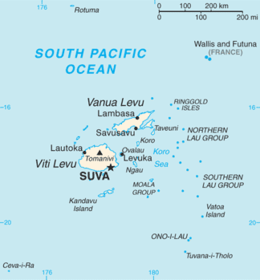
Moala Island
 Map of Fiji | |
 | |
| Geography | |
|---|---|
| Location | Fiji |
| Coordinates | 18°36′S 179°52′E / 18.600°S 179.867°ECoordinates: 18°36′S 179°52′E / 18.600°S 179.867°E |
| Archipelago | Moala Islands |
| Adjacent bodies of water | Koro Sea |
| Area | 65 km2 (25 sq mi)[1] |
| Length | 11 km (6.8 mi) |
| Administration | |
|
Fiji | |
| Division | Eastern |
| Province | Lau Province |
| Largest settlement | Naroi (pop. 550) |
| Demographics | |
| Population | 3000 (2014) |
| Pop. density | 46.15 /km2 (119.53 /sq mi) |
| Ethnic groups | Indo-Fijians ; other (Asian, Europeans, other Pacific Islander) |
Moala is a volcanic island in the Moala subgroup of Fiji's Lau archipelago. It has an area of 62.5 square kilometers (24.1 sq mi), making it the ninth largest island of Fiji. The highest point on the island of Moala, at a maximum elevation of 468 meters (1,535 ft), is called Delaimoala which has rich vegetation and consists of dark thick forest. The population of around 3000 live in eight villages. The chiefly village of these is Naroi, whose population is over 500. Economic activities include coconut farming, cocoa production, fishing and yaqona (kava) production.
The last Tui Moala to be installed under post colonial era was the Late Roko Jaoji Baba from the household "Wailiwaliwa". Naroi the village with its clan the Yavusa "Turagalevu" and the Yavusa Nayavutoka are believed to have existed until today. descendants of Kubunavanua's households: Ravula, Kolimatua and Tui Vanuakula.
Oral history of the Island depicted by the genealogical records which is funded by the British through Ratu Sukuna, whose mother is from Naocovonu now settled in Naroi. The genealogical records or Vola-ni-Kawa Bula e Viti abbreviated as VKB, dictates that all Moalans are to be registered under two great sons of pre-Colonial Fiji, and these are: Kubuavanua (now claimant to the title Tui Moala) and Rovarovaivalu. This separates the Island into two sub-regions: Moala Levu (as the claimant want to call themselves) and Moala Lailai. Moala Levu include: the clan that called themselves Yavusa Ratu, and Turagalevu or Turaga Ulu), whose influence is mainly felt on the north-west of the island from Naroi to Vadra. Moala Lailai, whose village of influence once felt all over the islands from Manukui (post Colonially called Vunuku) and Wainikelei (post-Colinially referred to as Keteira). These group of Moalans are on the south and eastern end of the Island from Vunuku, Cakova and to Nasoki.
The eight village that occupy the Island is said to be for the children of Rokomoutu whose sons include Rovarovaivalu, whose children in known as the "yavusa tinitini" (the clans of ten or ten clans), led by Naivalukuru. The village initially occupied was Wainikelei, with later settlers being Yavusa Ratu from Verata and Yavusa Nacuritutu on their return from Tonga. The three clans settled in the bay in proximity of each others. Event took their turn resulting in banishing of secondary clans from primary clans and warfare as a result of treachery a phenomenon that thrived at the time prior to discovery by James Cook, Bligh and the torrential colonial party. The villages that occupy Moala was Wainikelei (post-colonial Keteira); Nasau or Korosau (Naroi); Manukui (Vunuku; Cakova and Nasoki); Nuku, Vadra, and; Maloku. The latter villages were results of tokens of war between Manukui and Nasau.
Post Colonial Fiji resulted in the relocation on Nasau to Naroi today and the separation of Manukui to Vunuku, Cakova and Nasoki. Other settlers came in the form of Vadra and Maloku from other parts of Fiji as a formalisation of their effort in the last tribal war that occurred on the Island, that also politicised the establishment through the effort to register all Fijians to their village.
The Methodist Church is strong in Moala. Other Protestant beliefs exist in Moala today and these include: the JW's; SDA's, some Catholics or relative thereof. Since the island is populated by Indigenous population, the population is dominated by the first Catholicist movement that entered its domain, which surprisingly was not by the well known Maafu movement as depicted by some. Josaia Donumaibulu was the first laymen at the time to bring the message to the island, who was rejected by his own kin, where he then was invited to settle with his relative in Wainikelei, where he did.