Miva, Queensland
| Miva Queensland | |
|---|---|
 Country Women's Association rooms | |
 Miva | |
| Coordinates | 25°57′28″S 152°29′32″E / 25.95778°S 152.49222°ECoordinates: 25°57′28″S 152°29′32″E / 25.95778°S 152.49222°E |
| Postcode(s) | 4570 |
| Location | |
| LGA(s) | Gympie Region |
| State electorate(s) | Maryborough |
| Federal Division(s) | Wide Bay |
Miva is a rural community in the Gympie Region, Queensland, Australia. The town is on the Mary River.
History
The name Miva is taken from the name of a pastoral run belonging to Gideon Scott, a pastoralist in March 1851. It is thought to be an Aboriginal word indicating either stony knob or Moreton Bay chestnut.[1][2]
Miva Post Office opened by May 1908 (a receiving office had been open from 1888) and closed in 1976.[3]
Heritage listings
Miva has a number of heritage-listed sites, including:
- across the Mary River: Dickabram Bridge[4]
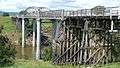 Dickabram Bridge
References
- ↑ "Miva (entry 47615)". Queensland Place Names. Queensland Government. Retrieved 13 September 2015.
- ↑ "NOMENCLATURE OF QUEENSLAND.—194.". The Courier-Mail. Brisbane: National Library of Australia. 14 May 1936. p. 14. Retrieved 8 July 2013.
- ↑ Premier Postal History. "Post Office List". Premier Postal Auctions. Retrieved 10 May 2014.
- ↑ "Dickabram Bridge (entry 600836)". Queensland Heritage Register. Queensland Heritage Council. Retrieved 8 July 2013.
External links
![]() Media related to Miva, Queensland at Wikimedia Commons
Media related to Miva, Queensland at Wikimedia Commons
This article is issued from Wikipedia - version of the 7/19/2016. The text is available under the Creative Commons Attribution/Share Alike but additional terms may apply for the media files.