Mitiaro
 | |
| Geography | |
|---|---|
| Area | 22.25 km2 (8.59 sq mi) |
| Coastline | 18.1 km (11.25 mi) |
| Highest elevation | 10.9 m (35.8 ft) |
| Highest point |
western makatea between Atai and Omutu |
| Administration | |
| Demographics | |
| Population | 219 (2006) |
Mitiaro, the fourth island in the Cook Islands group, is of volcanic origin. Standing in water 14,750 feet (4,500 m) deep it is four miles (6.4 km) across at its widest point.
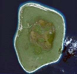
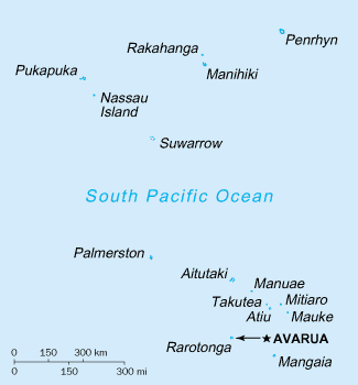
Geography
Mitiaro, also known as Nukuroa, is part of the Nga-Pu-Toru island group formerly, a volcano that became a coral atoll. The coral died forming fossilised coral (known locally as makatea).[1] The island is surrounded by a belt of this makatea, between 20 and 40 feet (6.1 and 12.2 metres) high and characteristic of islands in the southern group. The centre of the island is almost flat, quite swampy and contains two freshwater lakes teeming with eels (Anguilla obscura), which the locals call itiki, and the imported tilapia from Africa where it is known as bream. Beaches are limited but there are crystal-clear pools ideal for swimming in the subterranean limestone caves and the beach at low tide abounds in interesting marine life.
The island has four villages, located close together on the western side, from north to south:
- Taurangi (a former village)
- Atai (also called Arai)
- Auta
- Mangarei
- Takaue
The high school is located in the principal village, Arai. Takaue is the second largest village. Mitiaro Airport is located at the northern end of the island.
History
The native islanders had a pre-European history of harassment and subjugation by the warlike Atiuans, there were significant deaths in the population.
The island was discovered by missionary John Williams on 20 June 1823 who brought Christian beliefs and encouraged the settlers to leave their original faith. The estimated population at that time was less than 100 inhabitants.
During the 1840s the island was attacked again by Atiuans. On 31 October 1888 HMS Hyacinth commanded by Captain Bourke, hoisted the United Kingdom flag in the island. It was later merged to the Cook Islands until its annexation to New Zealand in 1901.[2]
| Historical population | ||
|---|---|---|
| Year | Pop. | ±% |
| 1823 | 100 | — |
| 1902 | 165 | +65.0% |
| 2008 | 219 | +32.7% |
Sources
- ↑ Mitiaro, Cook Islands Cookislands.org.uk
- ↑ Mitiaro, New Zealand Electronic Text Centre
External links
| Northern | ||
|---|---|---|
| Southern - Nga-pu-Toru | ||
| Southern - other | ||
Coordinates: 19°52′S 157°42′W / 19.867°S 157.700°W