Mithila, India
| Mithila متھلا मिथिला/ মিথিলা | |
|---|---|
| Aspirant state | |
 | |
| Country |
|
| Languages | Maithili |
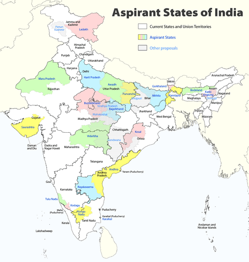
| Districts | 30 total: Araria, Begusarai, Bhagalpur, Darbhanga, Deoghar, Dumka, East Champaran, Godda, Jamtara, Jamui, Katihar, Khagaria, Kishanganj, Lakhisarai, Madhepura, Madhubani, Munger, Muzaffarpur, Pakur, Purnia, Saharsa, Sahebganj, Samastipur, Sheikhpura, Sheohar, Sitamarhi, Supaul, Vaishali, West Champaran, |
| Establishment status | Not yet established |
| Time zone | IST (UTC+05:30) |
Mithila (Hindi/Urdu: मिथिला متھلا , mithilā Tirhuta: মিথিলা) is a proposed state in India, comprising the Maithili speaking region of North Bihar bordering the Mithila state of Nepal.
The capital city of Mithila, India is expected to be Darbhanga if the proposal for the statehood is accepted.
History
Islamic invasion
During the regime of Harasimha Deva, the last king of the dynasty, Ghiyath al-Din Tughluq invaded Mithila in 1323 and gained control over the territory. Tughluq handed over the management of Mithila to Pt. Kameshwar Thakur. Thus, the sovereign power of Mithila, became part of Delhi Sultanate, but continued to enjoy complete autonomy.[1]
British rule
Maharaja Kameswar Singh was the last jamindar King of Mithila. The insurgency at Delhi in 1857, caused a grave concern to the English inhabitants, in Mithila. A revolutionary fervor began to permeate in the entire region.[1]
Rivers and floods
Mithila has seven major rivers, Mahananda, Gandak, Kosi, Bagmati, Kamala, Balan, and the Budhi Gandak.[2] They flow from the Himalaya mountains in the north to the Ganges river in the south. These rivers regularly flood, depositing silt onto the farmlands and sometimes causing death or hardship.
Cultures

On 18 August 2008 the Kosi embankment burst at Kusha in Nepal, near the border with India. The Kosi river inundated areas of Mithila that hadn't experienced floods in many decades.[3][4] 250 people died and 3 million people were forced from their homes.[5] More than 300,000 houses were destroyed and at least 340,000 hectares (840,000 acres) of crops were damaged.[5] Villagers in Mithila ate raw rice and flour mixed with polluted water. Hunger and disease were widespread. The Supaul district was the worst-hit; surging waters swamped 1,000 square kilometres (247,000 acres) of farmlands, destroying crops.[6]
-

The Kosi before it flooded in August 2008
-

The Kosi during the August 2008 flood
-

Satellite image of flood waters in Bihar as of 31 August 2008; Image:UNOSAT
Proposed Districts
- Araria district
- Begusarai
- Bhagalpur district
- Darbhanga district
- Deoghar district
- Dumka district
- East Champaran
- Godda district
- Jamtara district
- Jamui district
- Katihar district
- Khagaria district
- Kishanganj district
- Lakhisarai district
- Madhepura district
- Madhubani district
- Munger district
- Muzaffarpur district
- Pakur district
- Purnia district
- Saharsa district
- Sahebganj district
- Samastipur district
- Sheikhpura district
- Sheohar district
- Sitamarhi district
- Supaul district
- Vaishali district
- West Champaran
Bharatiya Janata Party
- BJP MP Kirti Azad from Darbhanga has organised dharnas and protests in support of Mithila.[7]
- Senior BJP leader, Tarakant Jha, present chairman of Bihar Legislative Council, has organised public rallies supporting Mithila.[8]
Janata Dal (United)
- In November 2011, Bihar Chief Minister Nitish Kumar also extended his support for the statehood of Mithila.[9][10]
- Shravan Chaudhary, JDU state president, has openly supported the demand for the statehood of Mithila.[11]
See also
- Maithil Brahmin
- Maithil Yadav
- Mithila, Nepal
- Tirhut
- Tirhuta script
- Maithili language
- Darbhanga
- Vidyapati
- Mithila Muslim
References
- 1 2 "Tirhut – The Land of Maa Sita – About Tirhut". Tirhutlive.in. Retrieved 4 May 2012.
- ↑ "Rivers of Bihar | Bihar Articles". Bihar.ws. Retrieved 4 May 2012.
- ↑ "A Dalit watch report on the flood camps in Bihar" (PDF). Indiawaterportal.org. 22 June 2011. Retrieved 4 May 2012.
- ↑ "Half of Bihar under water, 30 lakh suffer;". CNN IBN. 9 January 2008. Archived from the original on 3 September 2008. Retrieved 1 September 2008.
- 1 2 Michael Coggan in New Delhi (29 August 2008). "Death toll rises from Indian floods". Australian Broadcasting Corporation. Retrieved 4 May 2012.
- ↑ Kataria, Sunil (30 August 2008). "Bihar villagers desperate as floods spread". Reuters. Retrieved 4 May 2012.
- ↑ "Demand for Mithila state gains momentum, politicians join demonstration at Jantar Mantar". Post.jagran.com. 2 August 2011. Retrieved 4 May 2012.
- ↑ http://in.jagran.yahoo.com/epaper/article/index.php?page=article&choice=print_article&location=24&category=&articleid=6242779130240
- ↑ "article". Post.jagran.com. Retrieved 4 May 2012.
- ↑ "राज्य पुनर्गठन : व्यापक हो नजरिया « संपादकीय ब्लॉग". Jagraneditorial.jagranjunction.com. Retrieved 4 May 2012.
- ↑ "जेडी(यू) ने पृथक मिथिला राज्य की मांग का समर्थन किया- Navbharat Times". Navbharat Times. 22 January 2008. Retrieved 4 May 2012.
External links
| Proposed states |
|  |
|---|---|---|
| Proposed territories | ||
| Ikshvaku dynasty | .jpg) | ||||||||||
|---|---|---|---|---|---|---|---|---|---|---|---|
| Vanara | |||||||||||
| Rakshasa | |||||||||||
| Sages | |||||||||||
| Other characters | |||||||||||
| Places | |||||||||||
| Seven Kandas (Books) | |||||||||||
| Versions, adaptations & inspired works |
| ||||||||||
| Others | |||||||||||