Misteguay Creek
| Misteguay Creek | |
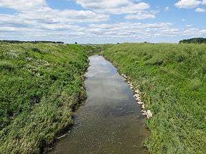 A channelized section of Misteguay Creek in Albee Township | |
| Country | United States |
|---|---|
| State | Michigan |
| Counties | Genesee, Shiawassee, Saginaw |
| Townships | Clayton, Venice, Hazelton, Maple Grove, Albee, Spaulding |
| Municipality | New Lothrop |
| Source | |
| - location | Clayton Township |
| - elevation | 809 ft (247 m) [1] |
| - coordinates | 42°58′01″N 83°53′54″W / 42.9669737°N 83.8982942°W [2] |
| Mouth | Flint River |
| - location | Spaulding Township |
| - elevation | 584 ft (178 m) [2] |
| - coordinates | 43°18′30″N 84°01′03″W / 43.3083596°N 84.0174739°WCoordinates: 43°18′30″N 84°01′03″W / 43.3083596°N 84.0174739°W [2] |
| Length | 38.4 mi (62 km) |
| Basin | 174.4 sq mi (452 km2) |
| Hydrologic Unit Codes | 040802040505, 040802040509, 040802040512, 040802040506, 040802040507, 040802040508 (USGS) |
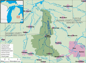 A map of Misteguay Creek and its watershed. | |
Misteguay Creek is a tributary of the Flint River, 38.4 miles (61.8 km) long,[3] on the central Lower Peninsula of Michigan in the United States. The stream drains an area of 174.4 square miles (452 km2)[4] in predominantly agricultural areas of the Flint/Tri-Cities region. Via the Flint and Shiawassee rivers, it is part of the watershed of the Saginaw River, which flows to Saginaw Bay of Lake Huron. Via Lake Huron and the Great Lakes system, it is part of the larger watershed of the St. Lawrence River.
Misteguay Creek begins in Clayton Township in Genesee County, approximately 1.9 miles (3.1 km) southeast of the village of Lennon and 3.5 miles (5.6 km) west of the city of Swartz Creek. It flows initially northwestward into Shiawassee County, then generally northward, through Venice and Hazelton townships and the village of New Lothrop in Shiawassee County; and Maple Grove, Albee, and Spaulding townships in Saginaw County. It flows into the Flint River in Spaulding Township, approximately 6.3 miles (10.1 km) east of the city of St. Charles. Several sections of the creek's course have been channelized.[5]
Tributaries
This is a list of named streams in Misteguay Creek's watershed, as identified by the National Hydrography Dataset. By default, the list is ordered from the mouth of the creek to its source.
| Name | Flows into | Length[3] | |
|---|---|---|---|
| 1 | Pattee Creek[6] | Misteguay Creek | 10.7 miles (17.2 km) |
| 2 | Bortle Drain[7] | Pattee Creek | 2.1 miles (3.4 km) |
| 3 | Mitchell Creek[8] | Misteguay Creek | 7.7 miles (12.4 km) |
| 4 | Northwood Creek[9] | Misteguay Creek | 11.3 miles (18.2 km) |
| 5 | Porter Creek[10] | Misteguay Creek | 14.6 miles (23.5 km) |
| 6 | Onion Creek[11] | Misteguay Creek | 9.2 miles (14.8 km) |
| 7 | Rush Creek[12] | Misteguay Creek | 9.1 miles (14.6 km) |
See also
References
- ↑ The National Map elevation query for coordinates given in cited GNIS record, http://viewer.nationalmap.gov/viewer/. Retrieved on 2015-08-18.
- 1 2 3 Geographic Names Information System. "Geographic Names Information System entry for Misteguay Creek (Feature ID #632507)". Retrieved 2015-08-18.
- 1 2 U.S. Geological Survey. National Hydrography Dataset high-resolution flowline data from The National Map, retrieved 2015-08-18.
- ↑ U.S. Geological Survey. National Hydrography Dataset, area data covering Misteguay Creek watershed, 12-digit Hydrologic Unit Codes 040802040505, 040802040509, 040802040512, 040802040506, 040802040507, and 040802040508. The National Map, retrieved 2015-08-18
- ↑ The National Map, accessed 2015-08-05.
- ↑ U.S. Geological Survey Geographic Names Information System: Pattee Creek
- ↑ U.S. Geological Survey Geographic Names Information System: Bortle Drain
- ↑ U.S. Geological Survey Geographic Names Information System: Mitchell Creek
- ↑ U.S. Geological Survey Geographic Names Information System: Northwood Creek
- ↑ U.S. Geological Survey Geographic Names Information System: Porter Creek
- ↑ U.S. Geological Survey Geographic Names Information System: Onion Creek
- ↑ U.S. Geological Survey Geographic Names Information System: Rush Creek