Mississippi River System
| Mississippi River System | |
| The Western Rivers | |
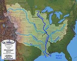 Map of the course, watershed, and major tributaries of the Mississippi River | |
| Country | United States |
|---|---|
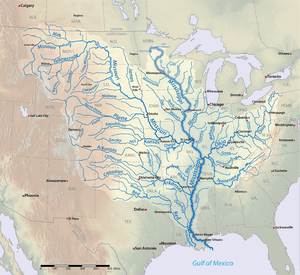 Mississippi River Tributaries | |
The Mississippi River System, also referred to as the Western Rivers, is a mostly riverine network of the United States which includes the Mississippi River and connecting waterways. The Mississippi River is the largest drainage basin in the United States.[1] In the United States, the Mississippi drains about forty-one percent of the countries rivers.[2]
From the perspective of natural geography and hydrology, the system consists of the Mississippi River itself and its numerous natural tributaries and distributaries. The major tributaries are the Arkansas, Illinois, Missouri, Ohio and Red rivers. Given their flow volumes, major Ohio River tributaries like the Allegheny, Tennessee, and Wabash rivers are considered important tributaries to the Mississippi system.[3] Before the Mississippi River reaches the Gulf of Mexico, it runs into its distributary, the Atchafalaya River.[1]
From the perspective of modern commercial navigation, the system includes the above as well as navigable inland waterways which are connected by artificial means. Important connecting waterways include the Illinois Waterway, the Tennessee-Tombigbee Waterway, and the Gulf Intracoastal Waterway. This system of waterways is maintained by the U.S. Army Corps of Engineers with a project depth of between 9 and 12 feet (2.7 – 3.7 m) to accommodate barge transportation, primarily of bulk commodities.[4]
The Mississippi River carries 60% of U.S grain shipments, 22% of oil and gas shipments, and 20% of coal.[5]
Major tributaries
| River | Length |
|---|---|
| 1. Upper Mississippi River | 1,250 miles |
| 2. Arkansas River | 1,469 miles |
| 3. Illinois River | 273 miles |
| 4. Missouri River | 2,522 miles |
| 5. Ohio River | 981 miles |
| 6. Red River | 1,290 miles |
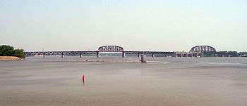
Upper Mississippi River
The Upper Mississippi River spans around 1,250 miles from Lake Itasca to Cairo.[6] Most of the Upper Mississippi goes through the center of the Driftless Area, around 15,000 square miles in Minnesota, Wisconsin, Iowa, and Illinois that has managed to stay free of glacial flows covering the past two million years.[7]
It is defined by a multitude of limestone bluffs that have been molded all the way since the last ice age, due to water melting from glaciers. The bottom of the river is composed of a thin layer of clay, silt, loam, and sand, which lay above a stratum of glacial outwash.[7]
The Upper Mississippi River covers approximately half of the Mississippi River's length. About 850 miles of the river is able to be navigated, from Minneapolis-St. Paul to the Ohio River. The river sustains a large variety of marine life, including 127 species of fish and 30 species of freshwater mussels.[8]
Arkansas River
The Arkansas River is one of the major tributaries in the Mississippi River system. It flows west to east starting in Colorado and dumping the Mississippi River. Its incredible length of 1,469 miles allows it to flow through Colorado, Kansas, Oklahoma, and Arkansas. It is the sixth largest river in the US, the second largest tributary to the Mississippi River System, and the 45th longest river in the world.[9]
Illinois River
The Illinois River is a principal tributary of the Mississippi River. The river runs approximately 273 miles (439 km) long, in the U.S. state of Illinois.[10] This river was important among Native Americans and early French traders as the principal water route connecting the Great Lakes with the Mississippi. The Illinois River meets the Mississippi at Pere Marquette State Park, which is near Grafton. The confluence of the rivers offers vistas that seem endless.
The Illinois River is relatively shallow, just like the Mississippi. In addition, the Illinois River is a "managed" river, just as the Mississippi River is. In 1848, the Illinois and Canal opened to promote connect Lake Michigan with the Mississippi River through the Illinois River to promote commerce.
Missouri River
The Missouri River is a long stream that originates in southwest Montana and flows southeasterly for 2,522 miles; passing through six states before finally entering the Mississippi River at St. Louis.[11] The Missouri River is the longest river on the North American continent. The Missouri River was one of the main routes for the watershed expansion of the United States during the 19th century.
Ohio River
The Ohio River runs 981 miles (1582 km) long, starting at the meeting of the Allegheny River and the Monongahela River in Pittsburgh, Pennsylvania; ending in Cairo, Illinois, where it then flows into the Mississippi. The Ohio River flows through six states, including, Illinois, Indiana, Ohio, Kentucky, Pennsylvania and West Virginia.
The river is a location with the capacity to provide enough water for over five million people. At its widest point, it is one mile wide at Smithland dam.The average depth is 24 feet deep which allows multiple species of fish to live there safely.
The water is also home to 150 species of fish ranging from catfish to certain species of salmon and trout.[12] The depth also allows for commerce throughout the river on barges. On average the Ohio River transports over 230 million tons of cargo. Typically, the cargo being shipped are energy resources such as coal. These resources account for 70% of the cargo. Along with shipping energy resources, the Ohio River also creates energy with dams and other power generating facilities. There are 20 dams and 49 other power generating facilities on the Ohio River.[13]
Red River
The Red River is the 10th longest river in the United States with a length of 1,290 miles.[9] It originates right outside the of the Rocky Mountains and stretches through multiple states with the main portion of it located in Texas. The river also crosses through Oklahoma, Arkansas, and Louisiana where then it links into the Mississippi River.[14] The Red River is mostly surrounded by rural farm land with the only surrounding major cities being Shreveport, Louisiana and Alexandria, Louisiana. The Red River is home to many oil fields with oil and gas production being one of the river's major aspects.
Major distributaries
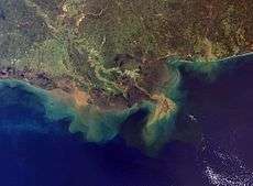
Mississippi River Delta
The Mississippi River Delta was created from thousands of years of sand, clay and organic material being deposited by the Mississippi River into the northern parts of the Gulf of Mexico. The delta is home to massive amounts of wildlife, and attributed to America's success as a superpower because of the economic development the delta has provided for the country.
Over the last three centuries, the delta has continuously collapsed, due to human alterations of the river system. Natural protection of land is exasperated the more the delta diminishes. The delta is important to the wildlife and people that it supports, along with the US economy. If the land loss continues at the pace its going, all these benefits can vanish.[15]
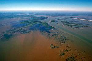
Atchafalaya River
The Atchafalaya River is one of the major distributaries in the Mississippi River System. It spans across 170 miles, making it one of the longest distributaries of the Mississippi River. The name of the river translated into English is "long river," which derives from the Native American word. The river is important for commerce because it shortens the distance to the Gulf of Mexico, also saving companies time and money.
The Army Corps of Engineers polices the flow of the Mississippi River into the Atchafalaya River by only allowing 30% of the flow to enter into the river.[16]
Historical use
The river system has always played a pivotal role in the lives of those who inhabit the surrounding area. Several different Native American groups lived in the surrounding area, including the Ojibwa, Winnebago, Fox and Choctaw Indians. The abundance of resources and overall size attracted these individuals to settle near the water. They named the Mississippi River. It was used for assisting with agriculture, gathering fish, and trading with others.[17]
The majority of natives to the river area were hunters and gatherers. The largest users of the rivers were the civilization today referred to as the Mound Builders, which created major farming settlements along the rivers. The silts deposited by the water made the surrounding areas very desirable due to the extremely fertile location and ideal place to farm. It is unknown as to why earth mounds were constructed, but there is speculation that they possibly were used for religious and ceremonial purposes.[18]
The river system, especially the Mississippi River, was used by Union armies as a means of invading and was host to several large battles during the Civil War. Mark Twain is regarded as having a large impact on molding American literature into what it is today because of his profound works on adventures and life on the rivers.[17]
Modern use
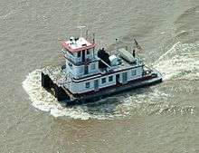
Today, the Mississippi River System, along with its connecting tributaries, is primarily used for transporting agricultural and manufactured goods across the span of the country. Among these goods is iron, steel, and mine products. The two largest rivers in the system, the Mississippi and Missouri, share the biggest amount of usage for the transportation of goods. Over 460 million short tons (420 million metric tons) and 3.25 million short tons of shipments respectively each year. The most common form of cargo transportation on the system is by tugboats pushing along large barges.[19]
Commerce
The Mississippi River System is a huge provider for the U.S. Economy. Due to its enormity, wilderness is able to flourish around the system and is one of the biggest markets in the Mid-West. The Mississippi River System accounts for 92% of the nations agricultural exports and 78% of the world's feed grains and soy beans. It also houses some of the biggest ports in America like The Port of South Louisiana and The Port of New Orleans.
These two ports account for over 500 million tons of shipped goods per year which is significantly larger than most ports in America. Some common things that are shipped include petroleum, iron, steel, grain, rubber, paper, wood, coffee, coal, chemicals, and edible oils.[20]
Ecology
Natural history
About two billion years ago, environmental tension altered the environment around the Mississippi River System basin, creating the mountain systems in North America. Erosion put further stress on the areas within the rivers, shaping depressions in the ground. Many years after this, the land continued to be molded into the Mississippi River System due to the overflowing of water from nearby oceans, causing constant flooding. Around two million years ago, glaciers up to 6,500 feet thick continued to disturb the environment. The receding formation of glaciers 15,000 years ago, at the end of the last ice age, left large amounts of water in North America, which created the rivers.[19]
The Mississippi River stemmed from Lake Itasca in northern Minnesota where it was only a tiny outlet stream. It worked its way 2,350 miles south to the Gulf of Mexico. Today, the Mississippi River is connected to hundreds of tributaries making up the Mississippi River System.
.jpg)
Wildlife
The Mississippi River and its floodplain are home to a diverse number of species. There are at least 260 different species of fish throughout the Mississippi. Forty percent of the United States' migratory waterfowl use the Mississippi River corridor during the Spring and Fall migration. Sixty percent of all North American birds (326 species) use the river Basin as their migratory flyway. There are 38 documented species of mussel that can be found from Cairo, IL and upstream to Lake Itasca.
There may be as many as 60 different species of mussel found on the lower part of the Mississippi. More than 50 mammal species have made the Upper Mississippi their home, along with at least 145 species of amphibians and reptiles in the Upper Mississippi environs. [21]
Human impacts
The biggest impact that humans have on the Mississippi River System comes in the form of pollution. Efforts made by the government to regulate and prevent more pollution from entering the waterways has stopped some, but regardless, pollution is still finding its way into the water. Fertilizers and insecticides have been swept away into the water, tampering with the environments ecosystems.[19]
The Mississippi has entered the twenty-first century as a system deeply altered by human actions. Accelerated runoff and accelerated sediment loads, which are associated with running water, have greatly impacted the system due to erosion affecting topsoil in agriculturally heavy areas.[22]
Flooding
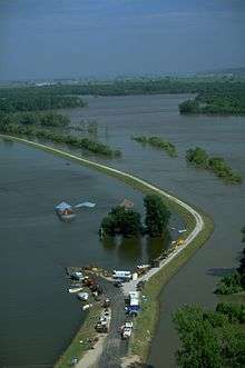
In 1993, the Mississippi River flood devastated seventeen thousand square miles of land, spanning across nine states. It was the worst flooding epidemic in the history of the United States. It is also referred to as a hundred year flood because the likelihood for it to occur is one in one hundred in any year. Over fifty people died due to the flooding, as well as profound home damage and economic losses totaling $10-12 billion. Twenty percent of the population that surrounded the flood area have since left due economic hardship or personal troubles. Today, the Mississippi River System is a deeply orchestrated natural trademark in the United States.[23]
The Army Corps of Engineers currently oversees all the responsibilities of making sure the rivers are best maintained to avoid more flooding. They abide by their goals of to "straighten, channelize, regularize and shackle the Mississippi." In order to subside the potential of more flooding, the Corps created levees, divided by a mile each, to restrict the river and control the flooding. Due to the manner in which the levees were paved, the river is unable to erode the shore. There are several floodways throughout the system to prevent a large amount of water from amassing. Instead, the buildup of water goes through these floodways. While they help prevent flooding, they also inhibit agriculture from prospering in some of the surrounding areas.[2]
References
- 1 2 "The Mississippi/Atchafalaya River Basin (MARB)". www.epa.gov. US Environmental Protection Agency. Retrieved 2 November 2016.
- 1 2 Watkins, Thayer. "The Missouri-Ohio-Mississippi River System". www.sjsu.edu. San Jose State University. Retrieved 2 November 2016.
- ↑ "Mississippi River". USGS Biological Resources. Archived from the original on 2005-10-28. Retrieved 2006-03-08.
- ↑ "The Mississippi River System". US Army Corps of Engineers. Retrieved 2006-03-08.
- ↑ Alan Greenblatt (2013-01-10). "Mississippi Blues: When The River Doesn't Run". NPR. Retrieved 2015-11-26.
- ↑ "The Herbert Hoover Presidential Library Association, West Branch, Iowa". Wayback Machine. Hoover Presidential Library Association. 4 January 2006. Retrieved 16 November 2016.
- 1 2 "River Geology – Mississippi Valley Traveler". mississippivalleytraveler.com. Avada. Retrieved 16 November 2016.
- ↑ "facts". www.umrba.org. Upper Mississippi River Basin Association. Retrieved 16 November 2016.
- 1 2 Kammerer, J.C. "Largest Rivers in the United States." Ofr87-242--. USGS, 1 Sept. 2005. Web. 26 Oct. 2016.
- ↑ Consortium, Mississippi Riverweb Museum. "Riverweb - Illinois River Basics". www.riverwebmuseums.org. Retrieved 2016-10-25.
- ↑ "Spotlight on the Big Muddy" (PDF).
- ↑ "List of Fish of the Central Ohio River". Ohio State Park. Department of National Resources. 8 February 2013. Retrieved 2 November 2016.
- ↑ "River Facts/Conditions". www.orsanco.org.
- ↑ Benke, A. C., & Cushing, C. E. (2005). Rivers of North America. [electronic resource]. Amsterdam ; Boston : Elsevier/Academic Press, c2005.
- ↑ "Discover the Mississippi River Delta | Restore the Mississippi River Delta". www.mississippiriverdelta.org. Environmental Defense Fund. Retrieved 16 November 2016.
- ↑ "Atchafalaya River - U.S. Gulf Coast States Geotourism". www.usgulfcoaststatesgeotourism.com. GeoTourism MapGuide. Retrieved 16 November 2016.
- 1 2 "Mississippi River Information and History - Four Rivers Realty". www.4rivers.com. Four Rivers Realty, Inc. Retrieved 16 November 2016.
- ↑ "The Mississippi River: Facts, History & Location | Study.com". Study.com. Study.com. Retrieved 16 November 2016.
- 1 2 3 Steif, Colin. "The Jefferson-Mississippi-Missouri River System". About.com Education. About.com Education. Retrieved 2 November 2016.
- ↑ United States. National Park Service. "Mississippi River Facts." U.S. Department of the Interior, 16 Mar. 2016. Web. 26 Oct. 2016.
- ↑ "Mississippi River Facts". NationalPark Service Centennial.
- ↑ Gupta, Avijit (28 February 2008). "Large Rivers: Geomorphology and Management". John Wiley & Sons.
- ↑ "Rivers of Life: Resources - Feature #6 (Floods)". cgee.hamline.edu. Center for Global Environmental Education. Retrieved 2 November 2016.
Coordinates: 47°14′23″N 95°12′27″W / 47.23972°N 95.20750°W