Mirror Pond
| Mirror Pond | |
|---|---|
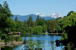 Mirror Pond from "The Emblem" in the summer | |
 Mirror Pond | |
| Location | Bend, Oregon |
| Coordinates | 44°03′43″N 121°18′51″W / 44.06206°N 121.3142°WCoordinates: 44°03′43″N 121°18′51″W / 44.06206°N 121.3142°W[1] |
| Type | reservoir |
| Primary inflows | Deschutes River |
| Primary outflows | Deschutes River |
| Catchment area | 700,000 acres (280,000 ha) |
| Basin countries | U.S. |
| Built | 1910 |
| Max. length | 0.6 mi (1 km) |
| Max. width | 400 ft (122 m) |
| Surface elevation | 3,586 ft (1,093 m) |
| Islands | 4 minor islands with trees |
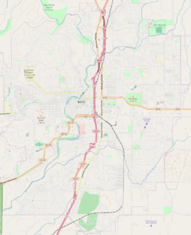
Mirror Pond is an impoundment of the Deschutes River in Bend, in the U.S. state of Oregon. It is between Pacific Power’s Bend Hydro dam and the Colorado dam, between RM 166 and 167.[2] The pond is flanked by Drake, Harmon, Pageant, Brooks, Columbia, Miller’s Landing, and McKay parks, as well as a number of buildings such as Pine Tavern and private homes.[3] Some people mistakenly consider the Galveston (Tumalo) bridge the upper boundary of Mirror Pond; others call the portion of the lake between Galveston bridge and the Colorado dam ″upper Mirror Pond.″[4]
History
Mirror Pond was created in 1910 by the construction of the Bend Water, Light & Power Company dam which provided the city with its initial source of electricity.[5] The dam has been owned by Pacific Power since 1926[6] and produces electricity for approximately 200 Bend households.[7]
Siltation
Since the construction of the dam, the flow of the Deschutes River deposits sediment from the approximately 700,000 acres (2,800 km2) Upper Deschutes River watershed into Mirror Pond. As a result, sediment has settled behind the dam, creating shallow mudflats along the margins. Mirror Pond is the only impoundment of the upper Deschutes River for electricity.[8]
In 1984, the community supported a $312,000 dredging project to repair the Pond’s features, but the result was not lasting.[9][10] The work included removal of some 60,000 cubic feet (1,700 m3) of material to achieve a minimum depth of 5 feet (150 cm).[11]
The sedimentation in Mirror Pond has again become a concern for the Bend community because the mudflats interfere with the flow of the river, recreational uses, and have altered the aesthetics of Mirror Pond in relation to Drake Park and downtown Bend tourism and commerce.[12]
Related
There is also an impoundment downstream created by the North Canal Dam which is a diversion for Pilot Butte Canal, now part of the Central Oregon Irrigation District.
See also
References
- ↑ "Mirror Pond". Geographic Names Information System. United States Geological Survey. Retrieved 2012-04-20.
- ↑ See topographic map, for example through ACME Mapper, accessed through the map resources of the coordinate link
- ↑ Pratt, Gerry, "Bend Finds Winner In Recreation Boom", The Oregonian, Portland, Oregon, 7 March 1967, p. 16.
- ↑ "Mirror Pond Questions". MirrorPond.info.
- ↑ "Electricity On". MirrorPond.info. Bend Bulletin. Retrieved 27 March 2013.
- ↑ "Pacific Power Officials Come To View Plant". MirrorPond.info. Bend Bulletin. Retrieved 27 March 2013.
- ↑ "How much power does the Mirror Pond dam generate?". MirrorPond.info. Retrieved 27 March 2013.
- ↑ Leslie Nelson (August 3, 2001). "Draft Deschutes River Subbasin Summary" (PDF). Oregon Department of Fish and Wildlife. p. 60. Retrieved April 20, 2012.
The only impoundment created by a hydroelectric facility in the upper subbasin is Mirror Pond on the Deschutes River within the City of Bend. Mirror Pond has become one of the primary attractions of Bend as a park for a variety of recreation and local events. However, this impoundment has created a settling basin for sediment being carried in the river and has been dredged on one occasion at a high cost in both dollars and environment disruption of the stream channel.
- ↑ "Mirror Pond Questions". MirrorPond.info. Retrieved 27 March 2013.
- ↑ Nick Grube (January 16, 2012). "Committee: Dredge Mirror Pond: Up to $5M project necessary to prevent formation of wetlands in Bend". The Bulletin. Retrieved April 20, 2012.
Silt has been accumulating at the bottom of Mirror Pond ever since Pacific Power & Light Co. built a hydroelectric dam near the Newport Avenue bridge in 1910. The last time it was dredged was in 1984, at a cost of $312,000.
- ↑ Steve Teft (August 11, 1982). "Mirror Pond dredging project taking shape". The Bulletin. Retrieved April 20, 2012.
The mile-long pond, which runs from the Galveston Avenue bridge to the Pacific Power & Light Co. dam, needs to be scooped out to a minimum depth of about five feet, a study published last summer said. ... The excavation is expected to begin next spring. A floating dredge would vacuum about 60,000 cubic feet of silt from the river bottom. A place to put the silt, which is enough to form a one-yard-square dirt column 40 miles high, has not been decided yet.
- ↑ "Mirror Pond". MirrorPond.info. Retrieved 27 March 2013.