Miramar, San Diego
| Miramar, San Diego | |
|---|---|
| Community of San Diego | |
| Miramar | |
|
| |
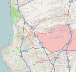 Miramar, San Diego Location within Northwestern San Diego | |
| Coordinates: 32°53′11″N 117°9′28″W / 32.88639°N 117.15778°W | |
| Country |
|
| State |
|
| County |
|
| City |
|
Miramar is a neighborhood in the northern part of the city of San Diego, California, USA. It includes residential areas and commercial and light industrial districts.
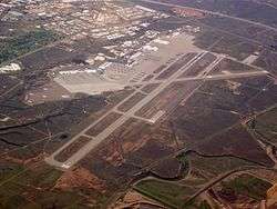
Most residents live on the Marine Corps Air Station Miramar (formerly Miramar Naval Air Station). Miramar was the site of the real TOPGUN made famous by the movie Top Gun in 1986. NAS Miramar was realigned by the Base Realignment and Closure (BRAC) program in 1995 and turned over to the Marine Corps as a fixed wing and helicopter base in 1999. To the north of MCAS Miramar is the suburb Mira Mesa. The neighborhood is located in City Council District 7. It is represented by Council member Scott Sherman.
The Miramar submarket consists of approximately fourteen million square feet of distribution, warehouse, office, and Miramar Road frontage retail related space. Miramar is one of San Diego County's most recognized real estate markets due in part to its central location, size, and traditional industrial characteristics. This market historically maintains one of the highest occupancy rates in the county. Recent occupancy rates were approximately 91%.
Miramar was originally part of Scripps Ranch, founded by Edward W. Scripps. He named the home he built on the ranch Miramar in the 1890s, after Archduke Maximilian's castle Miramare in Trieste, Italy. The name eventually became applied to the surrounding mesa. Loosely translated from Spanish it means "a view of the sea".
Before becoming a military base in 1950, Miramar was a small, isolated community centered on a railroad station. No buildings from the original Miramar survive.

See also
- Ruby Peters Miramar before the planes: of the U.S. Naval Air Station at San Diego, California; a rural settlement and one room school 1890-1950. (1984)
External links
Coordinates: 32°53′11″N 117°9′28″W / 32.88639°N 117.15778°W