Minute Man National Historical Park

Map of the Minute Man National Historical Park.
Not to be confused with Minuteman Missile National Historic Site.
Minute Man National Historical Park commemorates the opening battle in the American Revolutionary War. It also includes the Wayside, home in turn to three noted American authors. The National Historical Park is under the jurisdiction of the National Park Service and protects 970 acres (392.5 ha) in and around the Massachusetts towns of Lexington, Lincoln, and Concord.
Sites
These sites include:
- Concord's North Bridge, where on April 19, 1775, colonial commanders ordered militia men to fire back at British troops for the first time. British colonial militia and minutemen killed three regular army soldiers and wounded eight at the North Bridge Fight. This was the second battle of the day, after the brief fight at dawn on Lexington Common. In his 1837 poem, "Concord Hymn", thinker and author Ralph Waldo Emerson immortalized the North Bridge Fight as "the shot heard round the world". At this site also stands Daniel Chester French's well-known Minute Man Statue of 1875.[2] Across the North Bridge, opposite the Minute Man Statue is the Obelisk Monument. The Obelisk is believed to be the country's first memorial to its war casualties.
- The five-mile (8 km) "Battle Road Trail" between Lexington and Concord, which includes a restored colonial landscape approximating the path of the running skirmishes between British troops and Colonial militia, a monument at the site where Paul Revere was captured during his midnight ride, and the Hartwell Tavern, a restored 18th-century inn and house on the Battle Road, where living history programs are presented from May through October. The Battle Road Trail winds through fields and forests and is accessible from several different parking areas.
- The Wayside, home in turn to authors Amos Bronson Alcott and his daughter Louisa May Alcott, Nathaniel Hawthorne, and Margaret Sidney.
Park visitor centers are located at the hill overlooking the North Bridge and along Battle Road. The main visitor center, on Route 2A/Battle Road, features a 25-minute multi-media show, "Road to Revolution" that gives a good introduction to the Lexington-Concord events.
- Lexington Battle Green, formerly known as Lexington Common, site of the first action on April 19, 1775 is part of the park's story, but the Town of Lexington owns and maintains it. The Green is also where the Captain Parker Statue by Henry Hudson Kitson is located.
Image gallery
The Minute Man statue adjacent to the North Bridge
Memorial obelisk adjacent to the North Bridge
Captain William Smith House
See also
References
External links
|
|---|
|
|
|
|
|
|
|
| Wildlife Management Areas |
|---|
| Wildlife
Management Areas | |
|---|
| Wildlife
Sanctuaries |
- Billingsgate Island
- Carr Island
- E. Howe Forbush
- Egg Rock
- Grace A. Robson
- J.C. Phillips
- Knight
- Penikese Island
- Ram Island (Salisbury)
- Ram Island (Mattapoisett)
- Susan B. Minns
- Tarpaulin Cove
- Watatic Mountain
|
|---|
|
|
|
| |
|---|
|
- Black Pond Bog
- Boat Meadow
- Francis Newhall Woods
- Grassy Pond
- Greene Swamp
- Halfway Pond Island
- Hawley Bog
- Hockomock Swamp
- Hoft Farm
- Homer-Watcha Preserve
- Katama Plains
- McElwain-Olsen
- Miacomet Moors
- Reed Brook
- Drury
- Sandy Neck
- David H. Smith Preserve and Fire Trail
- Stacy Mountain
- Tatkon
|
|
|
|
|
|
|
|
|
|
|
|---|
|
| Topics | | |
|---|
|
| Lists by county | |
|---|
|
| Lists by city | Barnstable County | |
|---|
| Bristol County | |
|---|
| Essex County | |
|---|
| Hampden County | |
|---|
| Middlesex County | |
|---|
| Norfolk County | |
|---|
| Suffolk County | |
|---|
| Worcester County | |
|---|
|
|---|
|
| Other lists | |
|---|
|
-
 Category Category
-
 NRHP portal NRHP portal
- Massachusetts portal
|


 Old North Bridge, Concord, Massachusetts July 2005
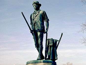 The Minute Man statue adjacent to the North Bridge
 Memorial obelisk adjacent to the North Bridge
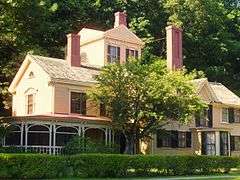
 Captain William Smith House