Minnesota's 8th congressional district
| Minnesota's 8th congressional district | |
|---|---|
|
Minnesota's 8th congressional district - since January 3, 2013. | |
| Current Representative | Rick Nolan (D) |
| Area | 27,583[1] sq mi (71,440 km2) |
| Distribution |
|
| Population (2000) | 614,935[2] |
| Median income | 37,911 |
| Ethnicity |
|
| Occupation | |
| Cook PVI | D+1[3] |
.tif.png)
|
|
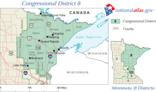
Minnesota's 8th congressional district covers the northeastern part of Minnesota. It is anchored by Duluth, Minnesota which is the fourth largest city in state. It also includes most of the Mesabi and Vermilion iron ranges. The district is best known for its mining, agriculture, tourism, and shipping industries.
Politically the district leans Democratic with a CPVI of D+1. However, the state DFLers in this district, particularly outside the Duluth area, are not as liberal as their counterparts in the Twin Cities. Nonetheless, elected Republicans are few and far between. Republican strength is concentrated in the district's southern portion, which stretches into the outer northern portion of the Twin Cities.
The district is currently represented by Democrat Rick Nolan, who defeated incumbent Republican Chip Cravaack in November 2012, Republican Stewart Mills in 2014 and 2016.[4]
List of representatives
| Congress | Representative | Party | Years | Notes |
|---|---|---|---|---|
| 58th | [Data unknown/missing. You can help!] | [Data unknown/missing. You can help!] | March 4, 1903 | District created |
| 58th – 60th | James Bede | Republican | March 4, 1903 – March 3, 1909 |
[Data unknown/missing. You can help!] |
| 61st – 65th | Clarence B. Miller | Republican | March 4, 1909 – March 3, 1919 |
[Data unknown/missing. You can help!] |
| 66th | William Leighton Carss | Farmer-Labor | March 4, 1919 – March 3, 1921 |
[Data unknown/missing. You can help!] |
| 67th – 68th | Oscar Larson | Republican | March 4, 1921 – March 3, 1925 |
[Data unknown/missing. You can help!] |
| 69th – 70th | William Leighton Carss | Farmer-Labor | March 4, 1925 – March 3, 1929 |
[Data unknown/missing. You can help!] |
| 71st – 72nd | William Pittenger | Republican | March 4, 1929 – March 3, 1933 |
[Data unknown/missing. You can help!] |
| 73rd | District inactive, all representatives elected At-large on a general ticket | March 4, 1933 – January 3, 1935 | ||
| 74th | William Pittenger | Republican | January 3, 1935 – January 3, 1937 |
[Data unknown/missing. You can help!] |
| 75th | John Bernard | Farmer-Labor | January 3, 1937 – January 3, 1939 |
[Data unknown/missing. You can help!] |
| 76th – 79th | William Pittenger | Republican | January 3, 1939 – January 3, 1947 |
[Data unknown/missing. You can help!] |
| 80th – 93rd | John Blatnik | Democratic–Farmer–Labor | January 3, 1947 – December 31, 1974 |
Resigned |
| 93rd | Vacant | December 31, 1974 – January 3, 1975 | ||
| 94th – 111th | Jim Oberstar | Democratic–Farmer–Labor | January 3, 1975 – January 3, 2011 |
Lost re-election. |
| 112th | Chip Cravaack | Republican | January 3, 2011 – January 3, 2013 |
Lost re-election. |
| 113th- | Rick Nolan | Democratic–Farmer–Labor | January 3, 2013 – present |
First elected in 2012. |
Recent elections
| Year | Election | Nominee | Party | Votes | % | Nominee | Party | Votes | % | |||
|---|---|---|---|---|---|---|---|---|---|---|---|---|
| 2002 | General | James Oberstar | Democratic | 193,959 | 69 | Bob Lemen | Republican | 88,423 | 31 | |||
| 2004 | General | James Oberstar | Democratic | 228,509 | 65 | Mark Groettum | Republican | 112,657 | 32 | |||
| 2006 | General | James Oberstar | Democratic | 194,677 | 64 | Rod Grams | Republican | 101,744 | 34 | |||
| 2008 | General | James Oberstar | Democratic | 240,586 | 67.6 | Michael Cummins | Republican | 114,588 | 32.2 | |||
| 2010 | General | James Oberstar | Democratic | 129,072 | 46.6 | Chip Cravaack | Republican | 133,479 | 48.2 | |||
| 2012 | General | Rick Nolan | Democratic | 192,748 | 54.5 | Chip Cravaack | Republican | 161,113 | 45.5 | |||
| 2014 | General | Rick Nolan | Democratic | 129,089 | 48.5 | Stewart Mills III | Republican | 125,357 | 47.1 | |||
| 2016 | General | Rick Nolan | Democratic | 178,893 | 50.2 | Stewart Mills III | Republican | 176,821 | 49.6 | |||
Competitiveness
Election results from presidential races:
| Year | Office | Results |
|---|---|---|
| 2000 | President | Al Gore 49 - George W. Bush 44% |
| 2004 | President | John Kerry 53 - George W. Bush 46% |
| 2008 | President | Barack Obama 53 - John McCain 45% |
| 2012 | President | Barack Obama 52 - Mitt Romney 46% |
| 2016 | President | Donald Trump 54 - Hillary Clinton 38% |
Historical district boundaries
See also
References
- ↑ "Minnesota congressional districts by urban and rural population and land area" (PDF). US Census Bureau. 2000. Retrieved 2007-04-02.
- ↑ "Fast Facts". US Census Bureau. 2000. Retrieved 2007-04-02.
- ↑ "Partisan Voting Index Districts of the 113th Congress: 2008 & 2012" (PDF). The Cook Political Report. 2014. Retrieved 2015-07-11.
- ↑ "Minnesota's 8th Congressional District election, 2016 - Ballotpedia". Retrieved 2016-11-14.
Coordinates: 47°15′01″N 92°57′50″W / 47.25028°N 92.96389°W