Minamiechizen, Fukui
| Minamiechizen 南越前町 | ||
|---|---|---|
| Town | ||
|
Town hall | ||
| ||
 Location of Minamiechizen in Fukui Prefecture | ||
 Minamiechizen Location in Japan | ||
| Coordinates: 35°50′N 136°12′E / 35.833°N 136.200°ECoordinates: 35°50′N 136°12′E / 35.833°N 136.200°E | ||
| Country | Japan | |
| Region |
Chūbu region Hokuriku region | |
| Prefecture | Fukui Prefecture | |
| District | Nanjō | |
| Area | ||
| • Total | 343.84 km2 (132.76 sq mi) | |
| Population (2013) | ||
| • Total | 11,446 | |
| • Density | 33/km2 (86/sq mi) | |
| Time zone | Japan Standard Time (UTC+9) | |
| Website |
www | |


Minamiechizen (南越前町 Minami-echizen-chō, lit. Southern Echizen Province) is a town located in Nanjō District, Fukui, Japan.
Minamiechizen was formed on January 1, 2005 by the merger of the two former towns of Imajō and Nanjō, and the former village of Kōno (all from Nanjō District).
As of 2013, the town had a population of 11,446 and a density of 33 persons per km². The total area is 343.84 square kilometres (132.76 sq mi).[1]
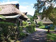
An old shukuba of Itadori, one of the 100 secluded villages in Japan
References
- ↑ 人口と世帯 [Population and households] (in Japanese). Minamiechizen, Fukui Prefecture, Japan: Town of Minamiechizen. 2013. Retrieved 2013-10-01.
External links
 Media related to Minamiechizen, Fukui at Wikimedia Commons
- Minamiechizen official website (Japanese)
- Minamiechizen Tourism website (Japanese)
This article is issued from Wikipedia - version of the 11/8/2015. The text is available under the Creative Commons Attribution/Share Alike but additional terms may apply for the media files.