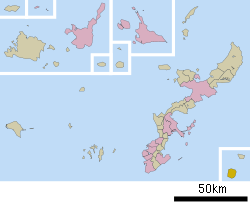
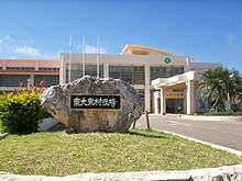
Minamidaitō, Okinawa
| Minamidaitō 南大東村 | |||
|---|---|---|---|
| Village | |||
| 南大東村• Minamidaitō-son | |||
|
Minamidaitō landscape | |||
| |||
 | |||
 Minamidaitō
| |||
| Coordinates: 25°49′44″N 131°13′55″E / 25.82889°N 131.23194°ECoordinates: 25°49′44″N 131°13′55″E / 25.82889°N 131.23194°E | |||
| Country | Japan | ||
| Region | Kyushu (Ryukyu) | ||
| Prefecture | Okinawa Prefecture | ||
| District | Shimajiri | ||
| Government | |||
| • - Mayor | Kenshō Nakada | ||
| Area | |||
| • Total | 30.57 km2 (11.80 sq mi) | ||
| Population (June 1, 2013) | |||
| • Total | 1,418 | ||
| • Density | 46.4/km2 (120/sq mi) | ||
| Time zone | Japan Standard Time (UTC+9) | ||
| -Tree | Livistona | ||
| - Flower | Hibiscus | ||
| Phone number | 09802-2-2001 | ||
| Address | 144-1 Aza Minami, Minamidaitō-son, Shimajiri-gun, Okinawa-ken 901-3895 | ||
| Website |
www | ||


Minamidaitō (南大東村 Minamidaitō-son) is a village located entirely on Minamidaitōjima in Shimajiri District, Okinawa Prefecture, Japan. Minamidaitōjima is located approximately 360 kilometres (220 mi) east of Okinawa Island.[1] Minamidaitō covers 30.7 square kilometres (11.9 sq mi).[2]
As of June 2013, the city had a population of 1,418 and a population density of 46.4 persons per km².[3]
Geography
The island is in the subtropical zone and was formed out of coral reef. With the exception of neighboring Kitadaitō, there is no inhabited land within 400 km of Minamidaitō.
Minamidaitō has a humid subtropical climate (Köppen climate classification Cfa) with very warm summers and mild winters. Precipitation is significant throughout the year; the wettest month is June and the driest month is February. The island is subject to frequent typhoons.
| Climate data for Minamidaitō, Okinawa | |||||||||||||
|---|---|---|---|---|---|---|---|---|---|---|---|---|---|
| Month | Jan | Feb | Mar | Apr | May | Jun | Jul | Aug | Sep | Oct | Nov | Dec | Year |
| Average high °C (°F) | 20.1 (68.2) |
20.4 (68.7) |
21.9 (71.4) |
24.6 (76.3) |
26.9 (80.4) |
29.0 (84.2) |
31.2 (88.2) |
30.9 (87.6) |
30.5 (86.9) |
28.1 (82.6) |
25.0 (77) |
21.8 (71.2) |
25.87 (78.56) |
| Daily mean °C (°F) | 17.1 (62.8) |
17.4 (63.3) |
18.8 (65.8) |
21.4 (70.5) |
23.9 (75) |
26.3 (79.3) |
28.1 (82.6) |
27.9 (82.2) |
27.2 (81) |
25.1 (77.2) |
22.3 (72.1) |
19.0 (66.2) |
22.88 (73.17) |
| Average low °C (°F) | 13.7 (56.7) |
14.1 (57.4) |
15.5 (59.9) |
18.5 (65.3) |
21.3 (70.3) |
24.1 (75.4) |
25.5 (77.9) |
25.2 (77.4) |
24.1 (75.4) |
22.2 (72) |
19.6 (67.3) |
16.0 (60.8) |
19.98 (67.98) |
| Average precipitation mm (inches) | 108.1 (4.256) |
80.9 (3.185) |
92.4 (3.638) |
103.7 (4.083) |
183.4 (7.22) |
207.2 (8.157) |
127.6 (5.024) |
192.8 (7.591) |
120.7 (4.752) |
169.3 (6.665) |
122.9 (4.839) |
120.2 (4.732) |
1,629.2 (64.142) |
| Average relative humidity (%) | 70 | 72 | 75 | 80 | 84 | 87 | 82 | 82 | 81 | 76 | 74 | 70 | 77.8 |
| Mean monthly sunshine hours | 117.3 | 114.0 | 141.4 | 171.5 | 177.0 | 200.2 | 262.4 | 233.4 | 227.4 | 181.3 | 122.7 | 106.5 | 2,055.1 |
| Source: NOAA (1961-1990) [4] | |||||||||||||
History
Minamidaitōjima remained uninhabited until formally claimed by the Empire of Japan in 1885.[1] In 1900, a team of pioneers from Hachijōjima, became the first human inhabitants of the island, and started the cultivation of sugar cane from 1903. Until World War II, Kitadaitōjima was owned in its entirety by Dai Nippon Sugar (now Dai Nippon Meiji Sugar). After World War II, the island was occupied by the United States. The village of Minamidaitō was established in 1946. Land reform was carried out in favor of the residents of Minamidaitō in 1964.[1] A freight train system was established and later dismantled in favor of contemporary transportation. The island was returned to Japan in 1972.
Economy
Sugarcane is the chief product of the village, and is cultivated in the central lowlands of the island.[2] There is also seasonal tourism and commercial fishing.
Rum is produced here. Grace Rum distillery, founded in 2004 is producing there two kinds of rum, Cor Cor red label and Cor Cor Green label, made from molasses and sugar juice respectively.[5]
Transportation
Minami-Daito Airport, located at the east of the island, connects Minamidaitō with the nearby island of Kitadaitō and Naha, Okinawa. Okinawa Prefecture operates the airport, and classifies it as a third class airport.[6] There is no port on the island and ships must be loaded/offloaded by crane.
Education
The village of Minamidaitō maintains a single school Minamidaitō Elementary and Junior high school.[7] As of 2010 the school had 95 elementary students and 49 junior high students. The village has no high school; students leave the island to complete their secondary education.[8]
Minamidaitō in popular culture
In 2013, a motion picture called Leaving on the 15th Spring (旅立ちの島唄 - 十五の春 Tabidachi no shima uta - jūgo no haru) was released. Themes include the relationship between inhabitants of Minamidaitō and Kitadaitō and families being torn apart because of the lack of a senior high school on the island.
References
- 1 2 3 "南大東(村)" [Minami Daitō]. Nihon Daihyakka Zensho (Nipponika) (in Japanese). Tokyo: Shogakukan. 2012. OCLC 153301537. Retrieved 2012-12-14.
- 1 2 "Minami Daitōjima". Encyclopedia of Japan. Tokyo: Shogakukan. 2012. OCLC 56431036. Retrieved 2012-12-14.
- ↑ 島の紹介 [Introduction to the Island] (in Japanese). Minamidaitō, Okinawa Prefecture, Japan: Village of Minamidaitō. 2010. Retrieved Dec 18, 2012.
- ↑ "Minamidaitojima Climate Normals 1961-1990". National Oceanic and Atmospheric Administration. Retrieved January 10, 2013.
- ↑ Kakzu, Island Sustainability
- ↑ "南大東空港" [Minami-Daito Airport]. Nihon Rekishi Chimei Taikei (in Japanese). Tokyo: Shogakukan. 2012. OCLC 173191044. dlc 2009238904. Retrieved 2012-12-07.
- ↑ 気象台・学校・郵便局 [Weather Station, Schools, Post Office] (in Japanese). Minamidaitō, Okinawa Prefecture, Japan: Village of Minamidaitō. 2013. Retrieved 2013-04-12. (Archive) "明治41年7月に八丈島から沖山岩作氏を招き、池之沢部落の一民家を利用して児童の教育を始めたのが、南大東村での教育の始まりであった。昭和23年南大東中学校の設置。"
- ↑ 学校の紹介 [Introduction to the School] (in Japanese). Minamidaitō, Okinawa Prefecture, Japan: Minamidaitō Elementary and Junior High School. 2010. Archived from the original on April 8, 2013. Retrieved 2013-04-12. "南大東小中学校は、小学生が95人、中学生が49人の小さな学校です。(平成22年6月7日現在)"
External links
 Minamidaito travel guide from Wikivoyage
![]() Media related to Minamidaitō, Okinawa at Wikimedia Commons
Media related to Minamidaitō, Okinawa at Wikimedia Commons
- Minamidaitō official website (Japanese)