Millbrae, California
| City of Millbrae | ||
|---|---|---|
| General law city[1] | ||
|
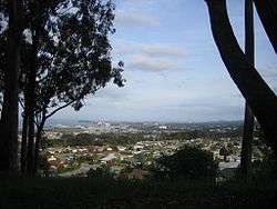
General view of Millbrae | ||
| ||
| Motto: A City In The Sun | ||
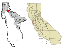 Location in San Mateo County and the state of California | ||
 City of Millbrae Location in the United States | ||
| Coordinates: 37°36′3″N 122°24′5″W / 37.60083°N 122.40139°WCoordinates: 37°36′3″N 122°24′5″W / 37.60083°N 122.40139°W | ||
| Country |
| |
| State |
| |
| County | San Mateo | |
| Incorporated | January 14, 1948[2] | |
| Government | ||
| • Type | Council-manager[1] | |
| • Mayor | Anne Oliva[3] | |
| Area[4] | ||
| • Total | 3.259 sq mi (8.439 km2) | |
| • Land | 3.247 sq mi (8.409 km2) | |
| • Water | 0.012 sq mi (0.030 km2) 0.36% | |
| Elevation[5] | 33 ft (10 m) | |
| Population (April 1, 2010)[6] | ||
| • Total | 21,532 | |
| • Estimate (2014)[7] | 22,703 | |
| • Density | 6,992/sq mi (2,700/km2) | |
| Time zone | Pacific (UTC-8) | |
| • Summer (DST) | PDT (UTC-7) | |
| ZIP code | 94030 | |
| Area code(s) | 650 | |
| FIPS code | 06-47486 | |
| GNIS feature ID | 1659756 | |
| Website |
www | |

Millbrae is a city in San Mateo County, California, United States, just west of San Francisco Bay, with San Bruno on the north and Burlingame on the south. The population was 21,536 at the 2010 census.
History
Darius Ogden Mills purchased land in the 1860s from the Sanchez family to build a country estate. The former Mills estate was bordered by what is now Skyline Boulevard, Bayshore Highway U.S. Route 101, Millbrae Avenue and Trousdale Drive. The estate became known as "Millbrae" from "Mills" and the Scottish word "brae," which means "rolling hills" or "hill slope." Children swam in three lakes situated on the estate and sold acacias to tourists before the Mills family began to sell the land for development. The estate's spectacular mansion burned down during a realistic "fire drill" in 1954.
Millbrae used a private patrol financed by fees from merchants and residents until 1941, when the San Mateo County Board of Supervisors created the Millbrae Police District. Records of the Internal Revenue Service document the licensing of several Millbrae bars for gambling; only after incorporation were gambling laws enforced in Millbrae and not until the 1950s was gambling defeated. In 1931, citizens organized a volunteer fire department, which remained entirely volunteer until 1938. The police and fire departments were housed together for several years at Hillcrest Boulevard and El Camino Real before the vital services moved to their permanent location in Millbrae's civic center, a few blocks west of El Camino.
For many Millbrae residents, the original Sixteen Mile House was a direct link to Millbrae's early days. The rest stop was built in 1872 by members of the Sanchez family, the original landholders of the Rancho Buri Buri, which at one time comprised parts of present-day Millbrae and Burlingame. The building faced demolition but was moved to its current location on Broadway and serves today as a tavern and restaurant.
Spurred largely by the desire to secure the Mills' estate for residential use and by the efforts of Millbrae's weekly newspaper, the Millbrae Sun, residents heatedly discussed incorporation for over a decade before voting to incorporate. Finally, on January 14, 1948, residents of Millbrae traveled to Sacramento to present their new city's charter. W.F. Leutenegger was elected mayor to represent Millbrae's nearly 8,000 residents. That year, Green Hills Elementary School opened as Millbrae's first new school in over 25 years, in anticipation of the educational needs of the post-war "baby boom" children. The new city's chief industries were agriculture, floriculture, dairy, and porcelain manufacturing. Many families that built the new city have never left.
In the 1950s, Millbrae residents united to resist efforts to divide the city by the planned Junipero Serra Freeway (I-280), which was later routed parallel to Junipero Serra Boulevard, then through a canyon in San Bruno up to Skyline Boulevard. An unsuccessful effort to save the original Sixteen Mile House in the 1970s led to the birth of the Millbrae Historical Society and eventual successful crusades to save the Millbrae train station and the historic building that has become the Millbrae Historical Museum. Such challenges, though inevitable, have only strengthened Millbrae's resolve to preserve the city's unique character and rich history.
Millbrae is also the home of Green Hills Country Club which was designed by famed golf course architect Dr. Alister MacKenzie (who designed other noteworthy courses such as Augusta National, Cypress Point, Royal Melbourne, Pasatiempo, and many more). The course was originally known as the Union League Golf Club of San Francisco (1930 to 1933) and Millbrae Country Club (1933 to 1945). The course provides a green belt in the center of the city that is the home of many animals, such as the red-tail fox, that otherwise would not be able to survive in the urban setting. It also may be the only area of the city where natural creeks still flow overground.
Transportation has shaped Millbrae's growth. From the start of the 20th century, the #40 "interurban" streetcar traveled through Millbrae, linking the city with San Francisco and San Mateo. Millbrae's high school children rode the streetcar to attend Burlingame High School until Capuchino High School opened on September 11, 1950. The streetcar line was dismantled just after Millbrae's incorporation, leaving the Southern Pacific Railroad as the only railway linking Millbrae with surrounding areas. The Sixteen Mile House marked Millbrae along the railroad route, located where Millbrae's first Corner Frame Shop stands today. In the 1940s, as long-time residents vividly recall, a hilltop literally was shaved away to produce landfill for expanding San Francisco Airport, which received an "international" designation in 1954 with the completion of the Central Terminal.
Today, Millbrae boasts over 21,000 residents. Residents are employed in various industries throughout the Bay Area and children attend one of five public elementary schools, or private schools. The city's senior citizen community recently dedicated a new senior wing within the Millbrae community center. Millbrae has Sister City relationships with La Serena, Chile, and Mosta, Malta.[8]
Geography
Millbrae has a total area of 3.26 sq mi (8.4 km2), of which, 3.25 sq mi (8.4 km2) is land and 0.01 sq mi (0.0 km2) (0.36%) is water.[9]
Climate
According to the National Weather Service, Millbrae enjoys a typical Mediterranean climate featuring cool, wet winters and dry, mild summers. Night and morning fog are common during the summer months. Frequent, westerly sea breezes keep temperatures relatively mild throughout the year with highs in the middle fifties (~15 °C) and lows in the lower forties (~8 °C) during the winter and highs in the lower seventies (~22 °C) and lows in the lower fifties (~13 °C) during the summer. Annual precipitation ranges from 20 inches (51 cm) in the lowlands to 32 inches (81 cm) in the hills near Skyline Boulevard and I-280; most of the rain falls from November through April. Snow is very rare; the last measurable occurrence was on February 5, 1976. The nearest National Weather Service station is at the nearby San Francisco International Airport, where records go back to early 1927. For more details, see San Bruno, California.
Environmental features
A wetland area in the eastern part of the city adjacent to U.S. highway 101 is habitat to the endangered species San Francisco garter snake, a species endemic to San Mateo County. At the western edge of the city the San Andreas Lake and the San Andreas Fault may be found.
Demographics
| Historical population | |||
|---|---|---|---|
| Census | Pop. | %± | |
| 1880 | 195 | — | |
| 1890 | 243 | 24.6% | |
| 1950 | 8,972 | — | |
| 1960 | 15,873 | 76.9% | |
| 1970 | 20,920 | 31.8% | |
| 1980 | 20,058 | −4.1% | |
| 1990 | 20,412 | 1.8% | |
| 2000 | 20,718 | 1.5% | |
| 2010 | 21,532 | 3.9% | |
| Est. 2015 | 22,795 | [10] | 5.9% |
2012
According to a 2012 estimate, the median income for a household in the city was $86,364, and the median income for a family was $124,027.[12] Males had a median income of $84,008 versus $70,975 for females. About 2.2% of families and 3.4% of the population were below the poverty line, including 2.2% of those under age 18 and 4.6% of those age 65 or over.[13]
2010
The 2010 United States Census[14] reported that Millbrae had a population of 21,532. The population density was 6,608.5 people per square mile (2,551.6/km²). The racial makeup of Millbrae was 10,177 (47.3%) White, 179 (0.8%) African American, 33 (0.2%) Native American, 9,205 (42.8%) Asian, 214 (1.0%) Pacific Islander, 776 (3.6%) from other races, and 948 (4.4%) from two or more races. Hispanic or Latino of any race were 2,555 persons (11.9%).
The Census reported that 21,217 people (98.5% of the population) lived in households, 58 (0.3%) lived in non-institutionalized group quarters, and 257 (1.2%) were institutionalized.
There were 7,994 households, out of which 2,593 (32.4%) had children under the age of 18 living in them, 4,543 (56.8%) were opposite-sex married couples living together, 868 (10.9%) had a female householder with no husband present, 315 (3.9%) had a male householder with no wife present. There were 268 (3.4%) unmarried opposite-sex partnerships, and 40 (0.5%) same-sex married couples or partnerships. 1,883 households (23.6%) were made up of individuals and 1,059 (13.2%) had someone living alone who was 65 years of age or older. The average household size was 2.65. There were 5,726 families (71.6% of all households); the average family size was 3.15.
The population was spread out with 4,337 people (20.1%) under the age of 18, 1,523 people (7.1%) aged 18 to 24, 4,960 people (23.0%) aged 25 to 44, 6,476 people (30.1%) aged 45 to 64, and 4,236 people (19.7%) who were 65 years of age or older. The median age was 44.8 years. For every 100 females there were 90.0 males. For every 100 females age 18 and over, there were 86.7 males.
There were 8,372 housing units at an average density of 2,569.5 per square mile (992.1/km²), of which 5,076 (63.5%) were owner-occupied, and 2,918 (36.5%) were occupied by renters. The homeowner vacancy rate was 0.7%; the rental vacancy rate was 4.8%. 13,968 people (64.9% of the population) lived in owner-occupied housing units and 7,249 people (33.7%) lived in rental housing units.
2000
As of the census[9] of 2000, there were 20,718 people, 7,956 households, and 5,513 families residing in the city. The population density was 6,446.4 people per square mile (2,492.0/km²). There were 8,113 housing units at an average density of 2,524.4 per square mile (975.8/km²).
There were 7,956 households out of which 28.3% had children under the age of 18 living with them, 55.7% were married couples living together, 9.9% had a female householder with no husband present, and 30.7% were non-families. 25.1% of all households were made up of individuals and 13.7% had someone living alone who was 65 years of age or older. The average household size was 2.56 and the average family size was 3.08.
In the city the population was spread out with 20.6% under the age of 18, 6.4% from 18 to 24, 27.5% from 25 to 44, 24.7% from 45 to 64, and 20.8% who were 65 years of age or older. The median age was 42 years. For every 100 females there were 89.8 males. For every 100 females age 18 and over, there were 87.0 males.
Government
In the California State Legislature, Millbrae is in the 13th Senate District, represented by Democrat Jerry Hill, and in the 22nd Assembly District, represented by Democrat Kevin Mullin.[15]
In the United States House of Representatives, Millbrae is in California's 14th congressional district, represented by Democrat Jackie Speier.[16]
Education
Millbrae has a reputation for having some of the best schools in the San Francisco Bay Area, despite enduring years of state budget cuts. Parents are actively involved in their children's scores and school functions.
Millbrae School District oversees four public elementary schools (Meadows, Green Hills, Lomita Park, and Spring Valley) and one middle school (Taylor Middle School, named after the family that owned land along Taylor Boulevard prior to the city being laid out). MSD is state-funded and does not receive local property taxes, and has endured budget cuts from the State since 2007. Parents and community contribute to the Millbrae Education Foundation, a volunteer-run organization that currently pays for all of computer education in the five schools, and music education for every elementary student.[17]
Millbrae has one private school at Saint Dunstan's, a Catholic church. The school provides education for grades K-8.
Millbrae has one public high school, Mills High School, which is part of the San Mateo Union High School District. Mills High School is the highest-scoring high school, test-wise, in San Mateo County. Mills High School is situated about a block away from the southern border of Millbrae with Burlingame. Although surrounded by land that is part of Millbrae, nearby Capuchino High School is located in San Bruno.
The city is served by the Millbrae Public Library of the San Mateo County Library, a member of the Peninsula Library System.
Police
On 4 March 2012, the San Mateo County Sheriff's Department took over responsibility for providing police services in Millbrae.[18]
Fire services
On December 29, 2014 The City of Millbrae combined services with Central County Fire which provides fire services to the cities of Millbrae, Burlingame and Hillsborough. Millbrae has two fire stations within its city limits.
New Source: http://www.ccfdonline.org/ (unfortunately history section of website has not been updated) New Source: http://www.burlingame.org/index.aspx?page=8&recordid=4354
Transportation
Millbrae is located between San Francisco and San Jose. U.S. Route 101 and Interstate 280 run along the eastern and western boundaries of the city, respectively. San Francisco International Airport is adjacent to the city.
The Millbrae Intermodal Station serves as a major transit hub for the Peninsula, connecting the BART, Caltrain, and SamTrans networks. It is the largest intermodal station west of the Mississippi river, in terms of construction size and land usage. The BART Pittsburg/Bay Point – SFO/Millbrae line and Richmond–Millbrae line serve the Millbrae Intermodal Station.[19] A SamTrans local line 43 serves Millbrae.
Economy
Millbrae's economy is driven mainly by its long strips of hotels. Because of its close proximity to San Francisco International Airport and to the city of San Francisco, and its advanced transit center that can connect people to all major cities/events in the Bay Area, many tourists opt to stay in Millbrae. Its downtown is mainly along El Camino Real and Broadway Avenue. There are many small shops, restaurants, a Safeway, Walgreens, Trader Joe's, Dress Barn, Office Depot, and Orchard Supply Hardware.
Top employers
According to the City's 2014 Comprehensive Annual Financial Report,[20] the top employers in the city are:
| # | Employer | # of Employees |
|---|---|---|
| 1 | City and County of San Francisco | 300 |
| 2 | Millbrae School District | 212 |
| 3 | Westin Hotel | 210 |
| 4 | 24 Hour Fitness | 208 |
| 5 | Safeway | 187 |
| 6 | A & C Health Care | 160 |
| 7 | Best Western | 149 |
| 8 | Mills High School | 143 |
| 9 | City of Millbrae | 125 |
| 10 | Magnolia of Millbrae | 100 |
Sister cities
Millbrae has three sister cities, as designated by Sister Cities International:
Footnotes
- 1 2 "Government". City of Millbrae. Retrieved February 4, 2015.
- ↑ "California Cities by Incorporation Date" (Word). California Association of Local Agency Formation Commissions. Retrieved August 25, 2014.
- ↑ "Meet the City Council". City of Millbrae. Retrieved April 1, 2016.
- ↑ "2010 Census U.S. Gazetteer Files – Places – California". United States Census Bureau.
- ↑ "Millbrae". Geographic Names Information System. United States Geological Survey.
- ↑ "Millbrae (city) QuickFacts". United States Census Bureau. Retrieved February 18, 2015.
- ↑ "Annual Estimates of the Resident Population for Incorporated Places: April 1, 2010 to July 1, 2014". Retrieved June 4, 2015.
- ↑ "City of Millbrae : Sister Cities Commission". Retrieved 2009-09-13.
- 1 2 "American FactFinder". United States Census Bureau. Retrieved 2008-01-31.
- ↑ "Annual Estimates of the Resident Population for Incorporated Places: April 1, 2010 to July 1, 2015". Retrieved July 2, 2016.
- ↑ "Census of Population and Housing". Census.gov. Retrieved June 4, 2015.
- ↑ American FactFinder. Factfinder.census.gov. Retrieved on 2014-06-12.
- ↑ U.S. Census Bureau
- ↑ "2010 Census Interactive Population Search: CA - Millbrae city". U.S. Census Bureau. Retrieved July 12, 2014.
- ↑ "Statewide Database". UC Regents. Retrieved November 23, 2014.
- ↑ "California's 14th Congressional District - Representatives & District Map". Civic Impulse, LLC. Retrieved March 12, 2013.
- ↑ http://millbraeedufun.org/donate/
- ↑ "Millbrae Police Department closes down". San Jose Mercury News. 3 March 2012. Retrieved 10 January 2013.
- ↑ BART Fares and Schedules
- ↑ City of Millbrae CAFR (2014)
External links
| Wikimedia Commons has media related to Millbrae, California. |
Municipalities and communities of San Mateo County, California, United States | ||
|---|---|---|
| Cities and towns | 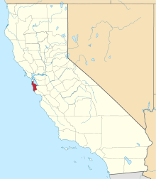 | |
| CDPs | ||
| Unincorporated communities | ||
| Ghost towns | ||
| Bodies of water |
|  |
|---|---|---|
| Counties | ||
| Major cities | ||
| Cities and towns 100k–250k | ||
| Cities and towns 50k–99k | ||
| Cities and towns 25k-50k | ||
| Cities and towns 10k–25k |
| |
| Sub-regions | ||