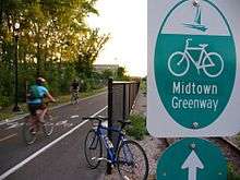
Midtown Greenway
|
Chicago, Milwaukee and St. Paul Railroad Grade Separation | |
|
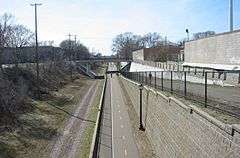
A look at the Midtown Greenway Trail looking westward from Nicollet Avenue. The rock on the left side is former ballast from the Milwaukee Road line. | |
  | |
| Location | Minneapolis, Minnesota |
|---|---|
| Coordinates | 44°57′00″N 93°17′10″W / 44.95000°N 93.28611°WCoordinates: 44°57′00″N 93°17′10″W / 44.95000°N 93.28611°W |
| Built | 1912 |
| Architect | Charles Fredrick Loweth, H.C. Lothholz |
| MPS | Reinforced-Concrete Highway Bridges in Minnesota MPS |
| NRHP Reference # | 05000508[1][2] |
| Added to NRHP | June 1, 2005 |

The Midtown Greenway is a 5.7-mile (9.2 km) rail trail in Minneapolis, Minnesota. It is considered under segregated cycle facilities.
Used both recreationally and for commuting, the partially below-grade Greenway runs east-west about one block north of Lake Street. It provides cyclists, inline skaters, runners and pedestrians a virtually traffic-free route across the city.
History
The Greenway lies in a former Milwaukee Road railroad corridor along 29th Street. This corridor had been abandoned west of Hiawatha Avenue but is still active east of Hiawatha as part of the Minnesota Commercial Railway. The rail line was originally built between 1879 and 1881; however, as traffic increased, the city of Minneapolis mandated a trench be built between Hiawatha and Irving avenues in 1910.[3] The trench, bridges and retaining walls were evaluated in 1989 as part of the Reinforced-Concrete Highway Bridges in Minnesota MPS, and then listed on the National Register of Historic Places as the Chicago, Milwaukee and St. Paul Railroad Grade Separation.[4] In 1993, the railroad property was purchased by the Hennepin County Regional Railroad Authority.[5]
Phase One of the Greenway opened in August 2000, starting at the intersection of 31st Street and Chowen Avenue, just inside Minneapolis city limits. Running between Lake of the Isles and Lake Calhoun, the Greenway enters the 29th Street trench near Hennepin Avenue. Phase Two opened in November 2004, running from 5th Avenue to Hiawatha Avenue. The rest of the Greenway to the Mississippi River opened as Phase Three in September 2006. In fall of 2007, the new Martin Olav Sabo Bridge was opened by Hennepin County and the city as Phase Four, eliminating a dangerous at-grade crossing at seven-lane Hiawatha Avenue.
Today
The Greenway consists of two one-way bike lanes and one two-way walking path, though they are combined in some places with space constrictions. Because of the historic nature of the corridor, it cannot easily be widened or modified.
To the west the Greenway connects directly to the Southwest LRT Trail, named after the future Southwest Corridor with which it will share right-of-way. It also connects to the Kenilworth Trail (which in turn connects to the Cedar Lake Trail) providing access to downtown Minneapolis and the western suburbs. To the east, the Greenway connects to West River Parkway, a part of the Grand Rounds Scenic Byway. In between, there is access to the Chain of Lakes, as well as the Light Rail Trail, connecting the Greenway to the Downtown East community.
The Freewheel Bike Center, consisting of a bike store and repair shop, as well as shower and locker facilities, opened in May 2008 at the Midtown Exchange near where the Greenway intersects Chicago Avenue.
Bike traffic on the Greenway has increased 261% between 2003 and 2011.[6]
Future
A fifth phase, which would carry cyclists across the Mississippi River, has an undetermined completion date. Planners hoped to use the Short Line Bridge to St. Paul, though the Canadian Pacific Railway (successor to Milwaukee Road) has not been receptive to the proposal. In addition, engineers have expressed concerns over the safety of the bridge.
Currently plans are to use the Greenway right-of-way for a streetcar line is also under consideration and has the support of the Greenway Coalition.[7]
References
- ↑ Nord, Mary Ann (2003). The National Register of Historic Places in Minnesota. Minnesota Historical Society. ISBN 0-87351-448-3.
- ↑ National Park Service (2007-01-23). "National Register Information System". National Register of Historic Places. National Park Service.
- ↑ "Bennett Lumber Site Environmental Assessment Worksheet" (pdf). City of Minneapolis. 2006. Retrieved 2006-07-06. (page 19)
- ↑ "National Register of Historic Places Listings - June 10, 2005". National Park Service. 2005. Retrieved 2006-07-06.
- ↑ "Midtown Greenway Brochure" (PDF). Hennepin County Regional Railroad Authority Board of Commissioners. 2006. Retrieved 2011-09-19.
- ↑ Minneapolis Department of Public Works (January 2012). "Minneapolis Bicyclist & Pedestrian Count Report 2011" (pdf). p. 2.
- ↑ Greenway Coalition
External links
| Wikimedia Commons has media related to Midtown Greenway. |
| Topics | |
|---|---|
| Lists by states |
|
| Lists by insular areas | |
| Lists by associated states | |
| Other areas | |
| |