Midtbygda, Nord-Trøndelag
| Midtbygda Meråker | |
|---|---|
| Village | |
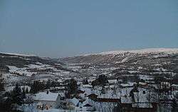
|
View of the village | |
 Midtbygda  Midtbygda Location in Nord-Trøndelag | |
| Coordinates: 63°24′50″N 11°44′34″E / 63.41389°N 11.74278°ECoordinates: 63°24′50″N 11°44′34″E / 63.41389°N 11.74278°E | |
| Country | Norway |
| Region | Trøndelag |
| County | Nord-Trøndelag |
| District | Stjørdalen |
| Municipality | Meråker |
| Area[1] | |
| • Total | 1.92 km2 (0.74 sq mi) |
| Elevation[2] | 120 m (390 ft) |
| Population (2009)[1] | |
| • Total | 936 |
| • Density | 488/km2 (1,260/sq mi) |
| Time zone | CET (UTC+01:00) |
| • Summer (DST) | CEST (UTC+02:00) |
| Post Code | 7530 Meråker |
Midtbygda (also called Meråker) is a village in the municipality of Meråker in Nord-Trøndelag county, Norway. The village is also the administrative center of the municipality.[3] The 1.92-square-kilometre (470-acre) village has a population (2009) of 936. The population density is 488 inhabitants per square kilometre (1,260/sq mi).[1]
Midtbygda is located along the Stjørdalselva river and the European route E14 highway. It is served by Meråker Station, which is a railway station located along the Meråker Line. The local Meråker Church lies about 2 kilometres (1.2 mi) west of the village of Midtbygda. The lake Funnsjøen lies about 6 kilometres (3.7 mi) to the north.
References
- 1 2 3 Statistisk sentralbyrå (1 January 2009). "Urban settlements. Population and area, by municipality.".
- ↑ "Meråker" (in Norwegian). yr.no. Retrieved 2011-05-06.
- ↑ Store norske leksikon. "Midtbygda – i Meråker" (in Norwegian). Retrieved 2011-05-06.
This article is issued from Wikipedia - version of the 8/1/2016. The text is available under the Creative Commons Attribution/Share Alike but additional terms may apply for the media files.