April 14–16, 2011, tornado outbreak
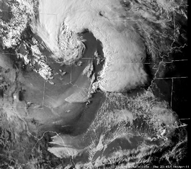 Visible satellite image of the storm at 2345 UTC on April 14 | |
| Type | Tornado outbreak |
|---|---|
| Duration | April 14–16, 2011 |
| Tornadoes confirmed | 178 confirmed |
| Max rating1 | EF3 tornado |
| Duration of tornado outbreak2 | 2 days, 4 hours, 20 minutes |
| Damage | $2.1 billion[1] |
| Casualties | 38 fatalities (+5 non-tornadic) |
|
1Most severe tornado damage; see Enhanced Fujita scale 2Time from first tornado to last tornado | |
One of the largest recorded U.S. tornado outbreaks occurred from April 14 to 16, 2011, resulting in 178 confirmed tornadoes across 16 states and severe destruction on all three days of the outbreak. A total of 38 people were killed from tornadoes and an additional five people were killed as a result of straight-line winds associated with the storm system. The outbreak of severe weather and tornadoes has led to 43 deaths in the Southern United States.[2][3] This was the largest number of fatalities in an outbreak in the United States since the 2008 Super Tuesday tornado outbreak.[4] However this outbreak was soon surpassed no less than two weeks later by the 2011 Super outbreak, which killed 324 people.
Meteorological synopsis
April 14
On April 14, a strong storm system in the southern section of the Rocky Mountains moved east to the central and southern Great Plains region during the afternoon and to the mid and lower Mississippi River Valley during the overnight hours. The system was accompanied by strong winds in the middle and high levels of the atmosphere along with cold upper air temperatures. With these elements coming together with moisture moving north from the Gulf of Mexico, it resulted in conditions favorable for severe weather.[5] A moderate risk of severe weather was issued for that day by the Storm Prediction Center as a result across eastern Oklahoma and neighboring parts of Arkansas, Kansas, Missouri and Texas.[6] With a dryline extending from southern Kansas to Texas,[7] thunderstorms began developing along the dryline across north and south central areas of Oklahoma by 3:10 pm CDT (2010 UTC).[8] These storms would form into supercells and move into eastern Oklahoma by 4:00 pm CDT (2100 UTC).[9]
Storm chasers in the region reported multiple funnel clouds and two touchdowns, neither of which resulted in damage. Several tornadoes were confirmed through storm chaser video and local emergency management services. A large, intense tornado later caused severe damage in and around the towns of Atoka and Tushka. Many houses were destroyed or flattened from what was at times a double tornado with two well-defined vortices. Numerous injuries were reported in the latter of these areas.[10] Two died and 43 more were injured in Tushka.[11] In Arkansas, strong winds produced by thunderstorms killed at least seven people.[12][13] Of those deaths, five were confirmed to have been from straight-line winds and two were as a result of a weak tornado embedded in an overnight squall line that tracked across the state.[14]
April 15
A moderate risk of severe weather also existed for April 15 across much of Alabama and Mississippi. During the pre-dawn hours into the morning of April 15, tornadic activity temporarily waned with only isolated activity. However, by late that morning, supercell thunderstorms developed again over parts of Mississippi, and tornadoes began to touch down again. A tornado emergency was declared for the northern Jackson metropolitan area shortly after 11:00 am CDT (1600 UTC), as a result of a widely photographed tornado that moved through parts of the city and the adjoining city of Clinton.[15] The destructive tornado moved across the area producing severe damage and numerous injuries according to WLBT coverage.[16] That afternoon, Mississippi State University spotters confirmed another large tornado in east-central Mississippi and west-central Alabama and the second tornado emergency of the outbreak was issued.[17][18] ABC 33/40 coverage reported that the tornado was 3/4 mile (1.2 km) in width.
Two additional tornado emergencies were also issued that afternoon for other storms in Attala County, Mississippi and Choctaw County, Alabama, and a fifth such issuance occurred near Leakesville, Mississippi that evening, where a large EF3 wedge tornado produced severe damage and 4 fatalities.[19][20][21] Local storm reports report at least 7 fatalities from the storms on April 15.[17]
April 16
The next day, a moderate risk of severe weather was issued for April 16 for the Carolinas and southern Virginia as the cold front tracked eastward and a mesolow developed across the Appalachians. As storms began moving into areas of strong atmospheric instability, a PDS Tornado Watch was issued shortly after noon and a high risk, the first of 2011, was issued shortly thereafter at 12:30 pm EDT (1630 UTC) for central and eastern North Carolina and immediate adjacent areas in South Carolina and Virginia. A squall line descended the Blue Ridge, and rapidly intensified along the Interstate 77 corridor.
As this line tracked eastward, wind damage was reported in Salisbury and Lexington, where tree and roof damage was widespread. The Salisbury storm - an EF1 - became the first confirmed tornado from the outbreak in North Carolina, followed shortly thereafter by tornadoes near Monroe (EF0) and north of Burlington (EF1). The Burlington area supercell was the first of what would turn out to be many multi-tornado, long-track supercells, producing additional tornadoes near Roxboro and South Hill, Virginia.
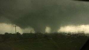
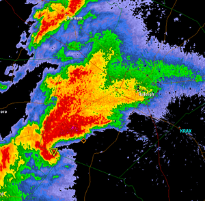
Moving rapidly to the east, the squall line entered areas that had experienced sunnier weather earlier in the day, and the squall line began to rapidly fragment into powerful discrete supercells by early afternoon. Explosive wind shear also made the atmosphere extremely prime for tornadic development. At about 3:15 pm EDT (1915 UTC), a tornado emergency - the sixth of the outbreak - was issued for an especially intense tornado in the Raleigh-Durham metropolitan area. This cell had developed in Moore County, and had at one point been a very strong tornado - a "high-end" EF3 - in the city of Sanford. A very prominent hook echo was easily visible on local radar returns, with a hail core and debris aloft also reflected in radar imagery.
This storm, which may have been a mile wide, tracked through the southeast edge of downtown Raleigh, on a southwest-to-northeast trajectory that passed through miles of suburbs surrounding the city. While damage in Wake County fluctuated between EF0 and EF2, it was accompanied by debris fallout from the Sanford area, when the storm was far more violent. Tracking through Raleigh, the tornado crossed three interstate highways, and narrowly missed a nuclear power plant as it moved from southwest to northeast through the densely populated (900,000+ population) county. The campus of Shaw University in downtown Raleigh was so severely damaged that classes were suspended for the remainder of the semester.
Soon afterwards, two additional tornado emergencies were issued farther south and east, as radar images of the developing supercells indicated very prominent hook echoes. Of the larger cities in eastern North Carolina, Fayetteville, Jacksonville, and Wilson all endured direct hits from EF2 or EF3 tornadoes. A tornado or tornado family that began in the city of Fayetteville, briefly closed interstate 95 in Johnston County, due to debris blocking the highway.
Late in the outbreak and farther into northeastern North Carolina, another EF3 tornado in Askewville, North Carolina, in rural Bertie County caused 12 fatalities and extensive damage in the towns of Askewville and Colerain, just west of the Chowan River. Additional destructive tornadoes - produced by the same line of supercells - caused damage northwest of the Charleston metropolitan area, and at several locations in the northeastern part of South Carolina, including Dillon County and multiple locations in Georgetown County.
Tornadoes also struck several locations in Virginia, including a destructive tornado in Gloucester County and a brief tornado 300 miles to the west in Rockbridge County. A tornado touched down in the switchyard of the Surry Nuclear Power Plant in southeastern Virginia, cutting off external power to the plant and leading its two reactors to trip. Because of this, a NRC Unusual Event, the lowest level of emergency, was declared. Diesel backup power was restored after a brief outage and the shutdown and cooling of the plant proceeded as designed with no physical damage to the reactors or release of radiation. A fuel oil leak occurred at an above-ground storage tank near the station's garage.[22][23] The supercells finally emerged into the Atlantic Ocean late that evening, ending the tornado outbreak after over 52 hours.
Tornadoes
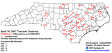
 Approximate touchdown location of tornadoes from April 14–16, 2011 Enhanced Fujita scale intensity key
| |||
| EF0 | EF1 | EF2 | EF3 | EF4 | EF5 | Total |
|---|---|---|---|---|---|---|
| 50 | 82 | 33 | 13 | 0 | 0 | 178 |
Raleigh/Sanford, North Carolina area
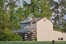
At 2:53 pm EDT (1853 UTC) on April 16, a moderately large and very intense tornado developed around Sanford, North Carolina in Lee County. A Lowe's Home Improvement Warehouse store in Sanford was destroyed, however, there were no fatalities or serious injuries there as staff spotted the approaching storm, and rushed staff and customers to safety in time. Several retailers adjacent to Lowe's were also heavily damaged. In a nearby residential area, 2 people were killed, and 30 homes were destroyed. Some homes were reduced to rubble by the tornado. Aerial footage broadcast on WRAL showed a very wide debris path through the area. The most severe damage was in this area, rated as a high-end EF3, where three other warehouses were destroyed and two apartment buildings lost their upper levels. Mobile homes in the area were destroyed and vehicles were thrown by the tornado.[24]
Generally maintaining its size and strength, the storm then paralleled U.S. Route 1, tracking near the unincorporated community of Moncure, in the southeast corner of Chatham County. Soon after, the tornado began to weaken. As the storm continued into southwestern Wake County, a tornado emergency was issued for areas downstream, including the city of Raleigh.
Moving into the suburban southwest of Wake County, the tornado weakened to EF1/EF0 intensity as it moved through the community of Holly Springs. However, many trees and power lines were downed, numerous houses were damaged, and several people were injured. In addition, debris tossed by the tornado was picked up by radar and pieces of destroyed homes were reported to have fallen in the adjacent towns of Apex and Cary. The tornado continued to track northeast, in the direction of downtown Raleigh; by this time a very sharply defined hook echo was visible on local radar. The tornado began passing through suburban subdivisions on the southwest side of Raleigh as it approached Downtown. Many homes sustained damage, mostly to roofs and from falling trees.[25] The tornado maintained EF1 intensity as it passed through neighborhoods into downtown Raleigh. Severe damage was reported to many commercial businesses in the South Saunders Street (US 70) area south of downtown near Interstate 40. Many local thoroughfares and neighborhoods were rendered impassable due to building debris, tree damage, and downed power lines. The Shaw University campus was badly damaged by the tornado. Live WRAL camera footage showed [26] a rain-wrapped tornado approach the city from the southwest and cross I-40 at South Saunders Street, accompanied by power flashes and flying debris. Many homes and businesses in the Raleigh area were badly damaged. Damage in the downtown area was rated EF1.[24]
After striking the downtown area, the tornado continued northeast, damaging Oakwood Cemetery and the St. Augustine's University campus. The tornado intensified again to EF2 strength as it passed through Raleigh's northeastern neighborhoods and subdivisions. Many homes were badly damaged, losing roofs and walls. Many trees and powerlines were downed and some homes were nearly destroyed. Still on the ground, it continued to track northeast through the northeastern suburbs, tracking along Capital Boulevard / U.S. Route 1 and U.S. Route 401 before tracking through a mobile home park at 4:05 pm EDT, producing severe damage, and killing four people. The tornado passed near suburban Rolesville, before nearing the Franklin County line at about 4:10 pm where it lifted.[25] The tornado was on the ground for an estimated 63 miles (101 km) and the tornado was about 530 yards (475 m) in width at its peak. The parent supercell tracked from Moore County, North Carolina to Franklin County to near Gloucester, Virginia, where it entered the Chesapeake Bay. Later tornadoes in Roanoke Rapids, North Carolina, Smithfield, Virginia, and Gloucester, Virginia were all produced by this same long-lived supercell, which also generated reports of other types of damage throughout its entire lifespan.[24][27]
Damage from the tornado was estimated to be at least $215 million, with $115 million in Raleigh and $100 million in Sanford.[28][29]
Fayetteville, North Carolina/Interstate 95
Another intense tornado formed at 3:40 pm EDT (1940 UTC) in the Wayside community in Hoke County, 6 miles northeast of Raeford. The tornado damaged homes in Hoke County near the Johnson Mill Road community. The strengthening storm entered the Cumberland County and the northwestern parts of the city of Fayetteville, near US Highway 401, and tracked NE through parts of Fort Bragg and surrounding neighborhoods. Numerous homes and businesses were destroyed in the Fayetteville area. Most damage in this early stage of the storm fluctuated between EF0 and EF2 in intensity, but some EF3 damage was noted later along the path.[30]
One person was killed, and at least 85 injuries were reported in Cumberland County. In Fayetteville, the worst damage appeared to be located between Yadkin Road and the entrance to Fort Bragg, in the northwest part of the city, where a small area of EF3 damage was seen. The Goodyear Plant sustained heavy damage, and locations near Pine Forest High School were also very heavily damaged. Womack Army Medical Center was operating on emergency backup power after power was cut to much of Fort Bragg. With a damage path up to a mile in width, 150 houses in northwest Fayetteville were destroyed, with at least an equal number damaged.[30]
Several houses were then destroyed between Spring Lake and Linden, as the storm grew into a large wedge tornado reported by motorists along the Interstate 95 corridor. The storm - consistently generating EF2 damage - then tracked along I-95 through Dunn and just south of Benson, where television footage revealed a broad, multiple-vortex tornado structure. A Food Lion warehouse and a trailer park were severely damaged in Dunn. Two people were ultimately killed by the tornado - one of the fatalities was in Cumberland County and the other was in Dunn in Harnett County, where a mobile home park was destroyed.[30]
Highways were blocked near Four Oaks, including Interstate 95, for a brief period of time. Flying debris and minor damage was reported in Smithfield just before the tornado dissipated, after generating a continual 65 mile-long (105 km)damage path. The parent supercell almost immediately produced additional tornadoes in Johnston and Wilson Counties, leaving additional damage in Micro and Wilson, tracking along Interstate 95 much of that distance.[30]
Damage in Johnston County reached $25 million, with 135 homes destroyed.[31]
Askewville, North Carolina
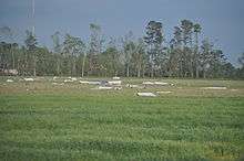
At around 6:55 p.m. EDT (2255 UTC) on April 16, a long-track tornado touched down one mile south of Askewville, North Carolina. The twister traveled to the northeast on an 18.8-mile (30.3 km) long path, and grew up to ½-¾ miles wide at times, before lifting approximately three miles east of Harrellsville, North Carolina.[32]
Bertie County emergency officials reported widespread catastrophic damage in the Askewville area, as 67 homes and 37 mobile homes were destroyed, with some homes ripped off their foundations. One business was also destroyed, and 19 other structures sustained lesser damage. There had also been some damage done to emergency vehicles as officials tried to clear the roadways in the damage path. The tornado destroyed seven mobile homes at Jake's Trailer Park, located off of Askewville Road, injuring two people.[33] This long-track tornado was the deadliest of the entire outbreak, killing 11 people (including a family of three and another couple) when the tornado hit the town of Colerain, and injuring at least 50 other people along its entire path.[34][35] On April 20, one of the injured people died at Pitt Memorial Hospital, increasing the death toll from the tornado to 12.[36] The tornado was rated an EF3 by the National Weather Service.
Bertie County was also struck by the 1984 Carolinas tornado outbreak, and on April 19, 1943, an F3 tornado destroyed every building in the town of Roxobel, in the western part of the county.[37]
Non-tornadic events
A late-season blizzard with high winds and moderate to heavy snow—up to 16 inches (40 cm)—occurred on the back side of the main low pressure area, particularly across western Kansas and Nebraska and parts of South Dakota. Several major highways, including Interstate 70 and Interstate 80, were closed as a result and travelers were stranded in numerous communities.[38][39] Heavy snow and isolated freezing rain was also reported across parts of the Upper Midwest, particularly in Minnesota and western Wisconsin.[40]
In the Northeastern U.S., as was seen in northern New York state, there were very high winds, sometimes gusting upwards of 70 miles per hour (110 km/h) associated with the massive storms that were active on April 16.[41]
Aftermath
| Outbreak death toll | |||
| State/Province | Total | County | County total |
|---|---|---|---|
| Alabama | 7 | Autauga | 3 |
| Marango | 1 | ||
| Washington | 2 | ||
| Arkansas | 2 | Pulaski | 2 |
| Mississippi | 1 | Greene | 1 |
| North Carolina | 24 | Bertie | 12 |
| Bladen | 4 | ||
| Cumberland | 1 | ||
| Harnett | 1 | ||
| Lee | 2 | ||
| Wake | 4 | ||
| Virginia | 2 | Gloucester | 2 |
| Totals | 38 | ||
| Only tornado-related deaths are included | |||
After the outbreak was over, many communities were left devastated, with severe destruction and no electricity. Several major cities were impacted by the outbreak, such as Raleigh, Little Rock, and Jackson. In the wake of the destruction as a result of the storms and tornadoes Alabama governor Robert J. Bentley declared a state of emergency for the entire state.[42][43] North Carolina governor Bev Perdue did likewise as a result.[44] 26 counties in Oklahoma and 14 counties in Mississippi were also placed under a state of emergency. In total, the tornadoes killed 38 people, injured many more, and caused at least 600 million dollars in damage.[45][46][47]
Historical comparisons
The outbreak was the deadliest tornadic event in the United States since the 2008 Super Tuesday tornado outbreak that occurred on February 5 and 6, 2008, when 57 people were killed across four states.[48] In North Carolina, the outbreak was the state's largest since March 1984.[49] Describing the outbreak, AccuWeather meteorologist Henry Margusity said, "There has not been a tornado outbreak in history over three days with this many tornadoes spawned by a single storm system".[50]
Tornado events of this magnitude are rare in North Carolina, with outbreaks on February 19, 1884 and March 28, 1984 the only historical precedents for outbreaks of this size, scale, and level of overall widespread damage. A March 31, 1973 outbreak produced over 25 tornadoes in the state, but all but one of those storms produced only F0 or F1 damage. The May 1989 tornado outbreak produced fewer, but more intense storms. More recently, an outbreak on May 17, 1998 produced 18 tornadoes in the state, including one F4 and one F3, but other storms in that outbreak were much weaker and short-lived.
See also
References
- ↑ http://www.ncdc.noaa.gov/billions
- ↑ Gargis, Peggy; Harriet McLeod (2011-04-16). "Tornadoes, storms kill at least 17 in South". Reuters. Archived from the original on 1 May 2011. Retrieved 2011-04-16.
- ↑ "SPC Storm Reports for April 16, 2011". Storm Prediction Center. 2011-04-17. Archived from the original on 19 April 2011. Retrieved 2011-04-17.
- ↑ Hayes, John L. (March 2009). "Service Assessment: Super Tuesday Tornado Outbreak of February 5–6, 2008" (PDF). U.S. Department of Commerce, National Oceanic and Atmospheric Administration, National Weather Service. Archived (PDF) from the original on 30 April 2011. Retrieved 2011-04-17.
- ↑ Barton, Brad (2011-04-14). "Updated Severe Weather Risk". WBAP. Archived from the original on 1 May 2011. Retrieved 2011-04-21.
- ↑ "Apr 14, 2011 2000 UTC Day 1 Convective Outlook". Storm Prediction Center. 2011-04-14. Retrieved 2011-04-22.
- ↑ "County sees hail, spared worst of storm". McPherson Sentinel. 2011-04-15. Retrieved 2011-04-23.
- ↑ "Regional Weather Discussion". National Weather Service. 2011-04-14. Retrieved 2011-04-22.
- ↑ Smoot, D.E. (2011-04-15). "Severe weather leaves rubble in its wake". Muskogee Phoenix. Retrieved 2011-04-23.
- ↑ "Severe Weather Live Blog". KXII-TV. Gray Television. April 14, 2011. Archived from the original on 15 May 2011. Retrieved April 14, 2011.
- ↑ "Severe Weather and Fire Weather Continue to Impact State" (Press release). Oklahoma Department of Emergency Management. 2011-04-15. Archived from the original on 13 May 2011. Retrieved 2011-04-16.
- ↑ "SPC Storm Reports for April 14, 2011". Storm Prediction Center. 2011-04-14. Archived from the original on 19 April 2011. Retrieved 2011-04-15.
- ↑ Michelle Edmonds (April 15, 2011). "Four fatalities in Arkansas caused by storms". KHTV. Archived from the original on 1 May 2011. Retrieved April 15, 2011.
- ↑ "Public Information Statement: 9:20 pm CDT Friday, April 15, 2011". National Weather Service, Little Rock. 2011-04-15. Archived from the original on 30 April 2011. Retrieved 2011-04-16.
- ↑ National Weather Service Jackson, Mississippi (2011-04-15). "Jackson Tornado Emergency". IEM National Weather Service product archive. Archived from the original on 19 April 2011. Retrieved 2011-04-16.
- ↑ Straw, Julie (2011-04-15). "Tornado tears through parts of Clinton". WLBT. Archived from the original on April 16, 2011. Retrieved 2011-04-16.
- 1 2 "SPC Storm Reports for April 14, 2011". Storm Prediction Center. 2011-04-15. Archived from the original on 19 April 2011. Retrieved 2011-04-16.
- ↑ National Weather Service Birmingham, Alabama (2011-04-15). "Alabama Tornado Emergency 1". IEM National Weather Service product archive. Archived from the original on 19 April 2011. Retrieved 2011-04-16.
- ↑ National Weather Service Jackson, Mississippi (2011-04-15). "Attala Tornado Emergency". IEM National Weather Service product archive. Archived from the original on 19 April 2011. Retrieved 2011-04-16.
- ↑ National Weather Service Mobile, Alabama (2011-04-15). "Choctaw Tornado Emergency". IEM National Weather Service product archive. Archived from the original on 19 April 2011. Retrieved 2011-04-16.
- ↑ National Weather Service Mobile, Alabama (2011-04-15). "Leakesville Tornado Emergency". IEM National Weather Service product archive. Archived from the original on 19 April 2011. Retrieved 2011-04-16.
- ↑ Tornado touchdown causes shutdown at Surry nuclear power plant
- ↑ NRC: Event Notification Report for April 20, 2011
- 1 2 3 "Public Information Statement 7:48 pm EDT April 17, 2011" (PDF). National Weather Service, Raleigh, North Carolina. 2011-04-17. Archived (PDF) from the original on 1 May 2011. Retrieved 2011-04-17.
- 1 2 http://www4.ncsu.edu/~nwsfo/storage/cases/20110416/
- ↑ "WRAL News extended storm coverage". WRAL-TV. 2011-04-16. Archived from the original on 30 April 2011. Retrieved 2011-04-18.
- ↑ WRAL coverage
- ↑ Unattributed (April 21, 2011). "Storm caused $115M in damage in Raleigh". News & Observer. Archived from the original on 30 April 2011. Retrieved April 26, 2011.
- ↑ Unattributed (April 26, 2011). "Structural damage alone totaled $57 million". Sanford Herald. Retrieved April 26, 2011.
- 1 2 3 4 "Public Information Statement 4:35 pm EDT April 18, 2011" (PDF). National Weather Service, Raleigh, North Carolina. 2011-04-18. Archived (PDF) from the original on 1 May 2011. Retrieved 2011-04-19.
- ↑ Tara Lynn and Kathy Hanrahan (April 20, 2011). "Johnston County reports $25M in damage". WRAL. Retrieved April 26, 2011.
- ↑ NEW: NWS rankings of tornadoes across the east, WNCT (information from the NWS Wakefield, Virginia Forecast Office), April 17, 2011.
- ↑ Tornado Tears Through Askewville Mobile Home Park, WITN, April 17, 2011.
- ↑ Tornado unleashes fury on Askewville, Roanoke-Chowan News Herald, April 17, 2011.
- ↑ Tornado kills 11 people across Bertie County, N.C., The Virginian-Pilot, April 17, 2011.
- ↑ Unattributed (April 20, 2011). "Tornado death toll rises to 24". NewsObserver. Archived from the original on April 22, 2011. Retrieved April 20, 2011.
- ↑ Blazich, Frank Jr. (April 17, 2011). "Roxobel Tornado, 19 April 1943". North Carolina Civil Defense History. Retrieved April 24, 2011.
- ↑ Corn, Mike (2011-04-15). "Blizzard, wind hammer NWKS". Hays Daily News. Archived from the original on April 22, 2011. Retrieved 2011-04-16.
- ↑ Tribune staff (2011-04-16). "Wacky weather leaves snow behind". Fremont Tribune. Archived from the original on April 22, 2011. Retrieved 2011-04-16.
- ↑ Gerhardt (2011-04-16). "Storm Summary Number 06 for Late Season Northern Plains and Great Lakes Winter Storm". Hydrometeorological Prediction Center. Archived from the original on 27 April 2011. Retrieved 2011-04-18.
- ↑ "High winds cause trees, power lines to fall". YNN. 2011-04-16. Archived from the original on April 22, 2011. Retrieved 2011-04-17.
- ↑ "Governor Visits Tushka To Survey Tornado Damage". Associated Press. 2011-04-16. Archived from the original on April 17, 2011. Retrieved 2011-04-16.
- ↑ "State of Emergency declared for Wake Co., 3 dead 24 injured". NBC 17. 2011-04-16. Archived from the original on April 17, 2011. Retrieved 2011-04-16.
- ↑ Unattributed (April 17, 2011). "Residents, crews surveying damage across the state". ABC News. Retrieved April 17, 2011.
- ↑ Unattributed (April 15, 2011). "State Of Emergency Declared For 26 Okla. Counties". KOCO. Archived from the original on April 17, 2011. Retrieved April 17, 2011.
- ↑ Unattributed (April 15, 2011). "MEMA reports 18 MS counties so far damaged by tornadoes". WLBT. Archived from the original on April 17, 2011. Retrieved April 17, 2011.
- ↑ Unattributed (April 15, 2011). "NWS: Friday's Storm Spawned Multiple Twisters". WAPT. Archived from the original on April 17, 2011. Retrieved April 17, 2011.
- ↑ Leger, Donna Leinwand; Doyle Rice (2011-04-17). "Severe storms kill at least 45". USA Today. Archived from the original on April 22, 2011. Retrieved 2011-04-18.
- ↑ "Perdue: Most catastrophic damage ever seen". WTVD. 2011-04-18. Retrieved 2011-04-18.
- ↑ Freedman, Andrew (2011-04-18). "Massive three-day tornado outbreak kills dozens; storm video and imagery". The Washington Post. Archived from the original on April 22, 2011. Retrieved 2011-04-18.
External links
- TornadoVideos.Net: Destructive Tornado near Jackson, MS! - Video of the Jackson, Mississippi tornado, uploaded to YouTube by TornadoVideos.Net
- Gallery of tornado damage in North Carolina from WRAL-TV