Michigan left

A Michigan left is an at-grade intersection design which replaces each left turn with a U-turn and a right turn. The design was given the name due to its frequent use along roads and highways in the U.S. state of Michigan since the late 1960s.[2] In other contexts, the intersection is called a median U-turn crossover or median U-turn.[1][3] The design is also sometimes referred to as a boulevard turnaround,[4] a Michigan loon[5] or a "ThrU Turn" intersection.[6][7]
Description

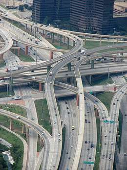
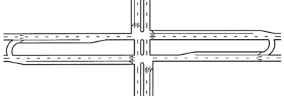
The design occurs at intersections where at least one road is a divided highway or boulevard, and left turns onto—and usually from—the divided highway are prohibited. In almost every case, the divided highway is multi-laned in both directions. When on the secondary road, drivers are directed to turn right. Within 1⁄4 mile (400 m), they queue into a designated U-turn (or cross-over) lane in the median.
When traffic clears they complete the U-turn and go back through the intersection. Additionally, the U-turn lane is designed for one-way traffic. Similarly, traffic on the divided highway cannot turn left at an intersection with a cross street. Instead, drivers are instructed to "overshoot" the intersection, go through the U-turn lane, come back to the intersection from the opposite direction, and turn right.
When vehicles enter the cross-over area, unless markings on the ground indicate two turning lanes in the cross-over, drivers form one lane. A cross-over with two lanes is designed at high-volume cross-overs, or when the right lane turns onto an intersecting street. In this case, the right lane is reserved for vehicles completing the design. Most cross overs must be made large enough for semi-trailer trucks to complete the cross over. This large cross-over area often leads to two vehicles incorrectly lining up at a single cross-over.
Narrow median
When the median of a road is too narrow to allow for a standard Michigan left maneuver, a variation can be used which widens the pavement in the opposite direction of travel. This widened pavement is known as a "bulb out"[6] or a "loon" (from the pavement's aerial resemblance to the aquatic bird).[5] Such a design is sometimes referred to as a Michigan loon; in Utah, as a ThrU Turn, which is a portmanteau combining the terms "Through" (the intersection, followed by a) "U Turn".[6]
Examples
United States
In 2013, Michigan lefts were installed in Alabama for the first time, in several locations along heavily-traveled U.S. Route 280 in metro Birmingham.[8]
Tucson, Arizona, began introducing Michigan lefts in 2013, at Ina/Oracle and Grant/Oracle. Their reception has been mixed.[9]
The design is relatively common in New Orleans, Louisiana, and its suburb Metairie, where city boulevards may be split by streetcar tracks,[10] and suburban thoroughfares are often split by drainage canals.[11] Some intersections using this design are signed similarly to those in Michigan, but with more descriptive text,[12] however in some cases the only signage is "No Left Turn" and local drivers are left to figure it out for themselves.[13]
Since the redevelopment of the intersection between University Boulevard (MD 193) and Colesville Road (US 29) in Silver Spring, Maryland, a Michigan left has been used to increase efficiency of traffic through an otherwise underdeveloped and congested intersection. Due to its proximity to the Capital Beltway, heavy traffic is handled more safely and efficiently.

The Michigan Department of Transportation first used the design at the intersection of 8 Mile Road (M-102) and Livernois Avenue (42°26′46″N 83°08′28″W / 42.4461°N 83.141°W)[14] in Detroit in the early 1960s. The increase in traffic flow and reduction in accidents was so dramatic that over 700 similar intersections have been deployed throughout the state since then.
North Carolina has been implementing Michigan lefts along US 17 in the southeastern part of the state, outside Wilmington. In 2015, a Michigan left was constructed at the intersection of Poplar Tent Road and Derita Road in the Charlotte suburb of Concord.
Columbus, Ohio introduced a Michigan left at the intersection of SR 161 and Strawberry Farms Boulevard in 2012. Reception has been mixed with several accidents occurring per year.
At least two Michigan lefts have existed in Texas. One was located at the intersection of Fondren Road and Bellaire Boulevard in Houston from the 1980s through 2007, when it was replaced with conventional left-turn lanes. Another was built in mid-2010 in Plano at the intersection of Preston Road and Legacy Drive.[15] In January 2014, the city announced plans to revert the turn to a traditional intersection as a result of drivers' confusion.
The city of Draper, Utah, a suburb of Salt Lake City, announced in 2011 that it would be building Utah's first "ThrU Turn" at the intersection of 12300 South and State Street, just off Interstate 15 through Salt Lake County. Construction began in summer 2011 and was completed in fall 2011.[6][16][17] Other similar intersections were implemented in South Jordan[18] and Layton.[19]
Australia
In Australia, where traffic drives on the left, the Victorian state government introduced the "P-turn", similar to the Michigan left, at one intersection in 2009. This requires right-turning vehicles to turn left then make a U-turn. As of May 2015, the intersection in the southeastern Melbourne suburb of Frankston remains the only one of its kind in the state, and local residents have called for its removal.[20]
United Kingdom
A similar style P-turn is used in the junction of the A4 Great West Road and A3002 Boston Manor Road in Brentford, England.
Canada
The design has been proposed in Toronto, Ontario, to relieve motorists who wish to make a left-turn on roadways which will contain a proposed streetcar line by the Transit City project.
Mexico
In Mexico, Guadalajara has a grade-separated variation of this setup in the intersection of Mariano Otero Avenue and Manuel Gómez Morín Beltway (20°37′50″N 103°26′06″W / 20.630666°N 103.434981°W).[21] Traffic flowing through Mariano Otero is routed through an overpass above the beltway, with two access roads allowing right turn on all four possible directions; the U-turns, meanwhile, are built underneath the beltway and allow the left turn from Mariano Otero avenue to the beltway. U-turn intersections are very common throughout Mexico, particularly in Mexico City.
Brazil
Brazil is also known to utilize this setup especially in São Paulo.
Hong Kong
This is the design at some busy junctions in Hong Kong. In Hong Kong Island examples include the junction of Fleming Road and Harbour Road in Wan Chai North, and the junction of Hennessey Road and Canal Road Flyover in Wong Nai Chung. In Kowloon this design exists between Cheong Wan Road and Hong Chong Road/Salisbury Road.
Applicable traffic studies
This type of intersection configuration, as with any engineered solution to a traffic problem, carries with it certain advantages and disadvantages and has been subject to several studies.
Studies have shown a major reduction in left-turn collisions and a minor reduction in merging and diverging collisions, due to the shifting of left turns outside the main intersection.[1] In addition it reduces the number of different traffic light phases, significantly increasing traffic flow. Since separate phases are no longer needed for left turns, this increases green time for through traffic. The effect on turning traffic is mixed.[1] Consequently, the timing of traffic signals along a highway featuring the design is made easier by the elimination of left-turn phases both on that highway and along intersecting roadways contributing to the reduction of travel times and the increased capacity of those roadways.[1]
It has been shown to enhance safety to pedestrians crossing either street at an intersection featuring the design, since they only encounter through traffic and vehicles making right turns. The left-turning movement, having been eliminated, removes one source of potential vehicle-pedestrian conflict.[1] One minor disadvantage of the Michigan left is the extra distance required for the motorist to drive. Sometimes the distance to the turnaround is as far away as 1⁄4 mile (400 m) past the intersection. This design leads to each motorist driving an additional 1⁄2 mile (800 m) to make a left turn.
See also
- Jughandle
 Roads portal
 U.S. Roads portal
References
- 1 2 3 4 5 6 7 Staff (August 2004). "Alternative Intersection Treatments". Signalized Intersections: Informational Guide. Federal Highway Administration. Archived from the original on May 10, 2009. Retrieved August 1, 2011.
- ↑ Staff (July 19, 2010). "Michigan Lefts". Michigan Department of Transportation. Retrieved December 20, 2010.
- ↑ "Unconventional Left-Turn Lanes Reduce Traffic Accidents, Congestion" (Press release). North Carolina State University. August 1, 1999. Retrieved December 20, 2010.
- ↑ Staff (October 18, 2001). "Minutes, Planning Commission Public Hearing, September 20, 2001" (PDF). City of Farmington Hills, Michigan. Archived from the original (PDF) on September 27, 2007. Retrieved August 1, 2011.
- 1 2 Hughes, Warren; Chappell, Debra; Chen, Shyuan-Ren (Clayton) (January 2005). "Geometric Design Treatments". Innovative Intersection Safety Improvement Strategies and Management Practices: A Domestic Scan. Federal Highway Administration. Retrieved August 17, 2013.
- 1 2 3 4 Staff. "Overview". Thru Turn Intersection. Utah Department of Transportation. Archived from the original on June 23, 2012. Retrieved September 24, 2011.
- ↑ Doctor, Mark; Shaw, Jeff; Merritt, George (April 4, 2013). "Intersection and Interchange Geometrics" (PDF). Every Day Counts 2 Spring Virtual Summits - 21st Century Solutions (PDF). Federal Highway Administration. Retrieved August 17, 2013.
- ↑ Smith, Mike (September 5, 2013). "U.S. 280: 'Michigan Left' U-turn at Valleydale scheduled to be in effect for Friday morning commute (animation)". The Birmingham News.
- ↑ "Little Love for Michigan Left". Arizona Daily Star. October 14, 2013. Retrieved March 3, 2014.
- ↑ Google (May 17, 2013). "S Claiborne Ave and S Carrolton Ave, New Orleans" (Map). Google Maps. Google. Retrieved May 17, 2013.
- ↑ Google (February 1, 2013). "W Metairie Avenue and Cleary Avenue, Metairie" (Map). Google Maps. Google. Retrieved February 1, 2013.
- ↑ Google (February 1, 2013). "Street View: W Metairie Avenue near Cleary Avenue, Metairie" (Map). Google Maps. Google. Retrieved February 1, 2013.
- ↑ Google (May 17, 2013). "Street view Northbound on S Carrolton Ave at S Claiborne Ave, New Orleans" (Map). Google Maps. Google. Retrieved May 17, 2013.
- ↑ Google. "8 Mile Road and Livernois Avenue" (Map). Google Maps. Google.
- ↑ Kim, Theodore (March 23, 2010). "Officials worry that 'Michigan left turn' at Plano intersection will confuse drivers". Dallas Morning News. Retrieved December 20, 2010.
- ↑ Davidson, Lee (November 11, 2011). "Newfangled intersection to open Monday in Draper". The Salt Lake Tribune. Retrieved August 17, 2013.
- ↑ "U-turns replace left turns at Draper intersection". KTVX. November 14, 2011. Retrieved August 17, 2013.
- ↑ "'Thru Turn' in effect at Bangerter and 7800 South intersection". West Jordan Journal. Retrieved June 11, 2012.
- ↑ "Layton Improved UDOT Open House Presentation". Utah Department of Transportation. Retrieved March 3, 2014.
- ↑ Tatman, Christian (May 15, 2015). "Roads Minister Luke Donnellan says Frankston's P-turn will remain". Frankston Standard Leader. Retrieved January 7, 2015.
- ↑ Google (December 20, 2010). "Mariano Otero Avenue and Manuel Gómez Morín Beltway, Guadalajara" (Map). Google Maps. Google. Retrieved December 20, 2010.
External links
| Wikimedia Commons has media related to Michigan left. |
- Michigan Left at Michigan Highways
- Synthesis of the Median U-Turn Intersection Treatment, Safety, and Operational Benefits
- Animation of a Michigan Left
- FHWA: MUT Case Study – Michigan Avenue at South Harrison Road in East Lansing (Michigan), published July 31, 2014