Miboro Dam
| Miboro Dam | |
|---|---|
 | |
| Location | Takayama, Gifu Prefecture, Japan. |
| Purpose | Power |
| Status | Operational |
| Construction began | 1957 |
| Opening date | 1961 |
| Dam and spillways | |
| Type of dam | Embankment, rock-fill |
| Impounds | Shō River |
| Height | 131 m (430 ft) |
| Length | 405 m (1,329 ft) |
| Elevation at crest | 766 m (2,513 ft) |
| Width (crest) | 12 m (39 ft) |
| Width (base) | 560 m (1,840 ft) |
| Dam volume | 7,950,000 m3 (10,400,000 cu yd) |
| Spillways | 3 |
| Spillway type | 1 x roller gate, 1 x drum gate, lower discharge tunnel |
| Reservoir | |
| Total capacity | 370,000,000 m3 (300,000 acre·ft) |
| Active capacity | 330,000,000 m3 (270,000 acre·ft) |
| Catchment area | 442.8 km2 (171.0 sq mi) |
| Surface area | 8.8 km2 (3.4 sq mi) |
| Normal elevation | 760 m (2,490 ft) |
| Power station | |
| Operator(s) | Kansai Electric Power Co., Inc. |
| Commission date | January/May 1961 |
| Hydraulic head | 192.1 m (630 ft) |
| Turbines | 2 x 128 MW Francis-type |
| Installed capacity | 256 MW |
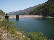
Miboro Dam (御母衣ダム Miboro damu) is a dam on the Shō River in Takayama, in the Gifu Prefecture of Japan. It supports a 256 MW hydroelectric power station. Of the nine dams on the Shō River, it is the furthest upstream.[1][2]
The dam flooded several villages and shrines, submerging them completely, two cherry trees were taken from one of the submerged shrines and placed in Shirakawa-go where it is said that each petal represents a memory from someone who lived in the villages before they were flooded.[3]
References
- ↑ "Hydropower & Dams in South and East Asia" (PDF). Hydropower and Dams. p. 9. Retrieved 3 October 2010.
- ↑ "Kansai Electric Power Miboro power plant" (in Japanese). Suiryoku. Retrieved 28 July 2013.
- ↑ "Miboro Dam Japan Tourist Information". Retrieved 24 Aug 2014.
| Wikimedia Commons has media related to Miboro Dam. |
Coordinates: 36°08′17.7″N 136°54′38.9″E / 36.138250°N 136.910806°E
This article is issued from Wikipedia - version of the 11/19/2015. The text is available under the Creative Commons Attribution/Share Alike but additional terms may apply for the media files.