Mi Teleférico
Coordinates: 16°30′00″S 68°09′00″W / 16.50000°S 68.15000°W
|
| |||
|
Red Line cable car connecting La Paz and El Alto | |||
| Overview | |||
|---|---|---|---|
| Native name | Mi Teleférico | ||
| Owner | Empresa Estatal de Transporte por Cable "Mi Teleférico" | ||
| Locale | La Paz, Bolivia | ||
| Transit type | Gondola lift | ||
| Number of lines | 3 (7 in planning)[1] | ||
| Number of stations | 10 (17 in planning)[1] | ||
| Website | www.miteleferico.bo | ||
| Operation | |||
| Began operation | 30 May 2014 | ||
| Number of vehicles | 443 gondola cars | ||
| Headway | 12 sec | ||
| Technical | |||
| System length | 10 km (6.2 mi) | ||
| |||
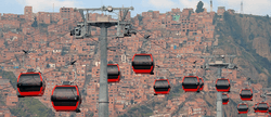
Mi Teleférico (Spanish pronunciation: [mi tele'feɾiko], English: My Cable Car), also known as Teleférico La Paz–El Alto (La Paz–El Alto Cable Car), is an aerial cable car urban transit system opened in 2014 in the Bolivian city of La Paz.[2] Currently three lines are in operation and seven more lines are in the planning stage or under construction. The system was built by the Austrian company Doppelmayr Garaventa Group.[3] The first two lines, Red and Yellow, connect La Paz with the neighboring city of El Alto. The network currently consists of 10 stations, one of which, Chuqui Apu/Libertador, is shared by both the Yellow and Green Lines.
At 10 km (6.2 mi) in length, Phase One (the first three lines) was considered to be the longest aerial cable car system in the world upon its completion in 2014,[4] and Phase Two will extend the system length by some 20 km (12 mi).[5] Additionally, while other urban transit cable cars like Medellín's Metrocable complement existing rapid transit systems, Mi Teleférico will be the first rapid transit network to use cable cars as the primary mode of transportation.[6]
The system was planned in order to address a number of problems, including a precarious public transit system that could not cope with growing user demands, the high cost in time and money of traveling between La Paz and El Alto, chaotic traffic with its subsequent environmental and noise pollution, and a growing demand for gasoline and diesel fuel, which are subsidized by the state.
History
In the 1970s, under city councilman Mario Mercado Vaca Guzmán, a team planned an aerial cable car route connecting the neighborhoods of La Ceja in El Alto and La Florida in La Paz.
In 1990, under mayor Ronald MacLean Abaroa, a feasibility study was undertaken for a cable car between La Ceja, El Alto and the Plaza de San Francisco, La Paz. The most controversial aspects of the plan were the fare, the low passenger capacity, and the proximity to the Basilica of San Francisco. During the 1991 elections, the Conciencia de Patria (CONDEPA) party candidate Julio Mantilla argued against a cable car, claiming it would cost minibus drivers their livelihoods and impact privacy.
In 1993, mayoral candidate Mónica Medina, also of the CONDEPA party, made aerial transit one of her campaign promises, modifying the original idea of a single line into a system of interconnected cable car lines with a hub on Lainkakota hill.
In 2003, under mayor Juan del Granado, the project returned to the table, but details such as tower placement stalled the work.[7] The planned San Francisco terminal was moved to the Zapata soccer field near the Higher University of San Andrés, but the idea was still too controversial to move ahead.
In 2011, the Municipal Government of La Paz carried out a study on potential ridership demand, and found that the city handles 1.7 million trips per day, including 350,000 trips between La Paz and El Alto.
In July 2012, Bolivian President Evo Morales Ayma sent the Plurinational Legislative Assembly a bill for the construction of a cable car to connect El Alto with the center and south of La Paz. Morales called together the mayor of La Paz, Luis Revilla, the mayor of El Alto, Édgar Patana, and the governor of the La Paz Department, César Cocarico, to participate in the project. The project is financed by the country's National Treasury with an internal loan from the Central Bank of Bolivia. The cable car was inaugurated and began operation on May 30, 2014.
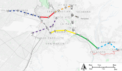
Lines

The Mi Teleférico system consists of three monocable aerial cable car lines, the Red Line, Yellow Line, and Green Line, which are also the colors of the Bolivian flag. Each line has a maximum capacity of 6000 passengers per hour. There are 443 cable car cars distributed throughout the network, each of which seats 10 passengers. Cars depart every 12 seconds, and the network is open 17 hours a day.[8]
| Line | Terminus stations | Length | Travel time | Stations | Opened |
|---|---|---|---|---|---|
| Red Line | 16 de Julio/Jach'a Qhathu – Estación Central/Taypi Uta | 2.4 km (1.5 mi) | 10 min | 3 | 30 May 2014 |
| Yellow Line | Mirador/Qhana Pata – Chuqui Apu/Libertador | 3.9 km (2.4 mi) | 13.5 min | 4 | 15 September 2014 |
| Green Line | Chuqui Apu/Libertador – Irpawi/Irpavi | 3.7 km (2.3 mi) | 16.6 min | 4 | 4 December 2014 |
On July 1, 2014, Evo Morales announced five new interconnected lines to be built in the coming years. On January 26, 2015, the law permitting construction of Phase Two was passed, increasing the number of new lines to six and committing $450 million to the project. Phase Two will extend the system by 20.3 km (12.6 mi).[5][9] A seventh line was announced in February 2016.[10] The first Phase Two line that is scheduled to open is the Blue Line, which has its inauguration planned for 6 March 2017.[11] The lines planned for Phase Two are:
| Line | Terminus stations | Length | Travel time | Stations | Opened |
|---|---|---|---|---|---|
| Blue Line | Rio Seco - 16 de Julio/Jach'a Qhathu | 4.7 km (2.9 mi) | 5 | Planned for 6 March 2017[11] | |
| Orange Line | Central/Taypi Uta – Plaza Villarroel | 2.6 km (1.6 mi) | 4 | ||
| White Line | Plaza Villarroel – Chuqui Apu/Libertador | 4.2 km (2.6 mi) | 5 | ||
| Purple Line | Terminal de Transporte – San Jose | 4.4 km (2.7 mi) | 4 | ||
| Sky Blue Line | El Prado – Chuqui Apu/Libertador | 0.9 km (0.56 mi) | 3 | ||
| Brown Line | Monumento Busch – Villa Copacabana[1][9] | 3.5 km (2.2 mi) | 2 | ||
| Silver Line | 16 de Julio/Jach'a Qhathu – Chuqui Apu/Libertador[10] | 2.6 km (1.6 mi) | 3 |
Stations
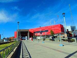
All stations have both a Spanish name and an Aymara name.
Red Line - Línea roja
| Station[1] | Notes |
|---|---|
| Estación Central/Taypi Uta | former central railway station |
| Cementerio/Ajayuni | main cemetery |
| 16 de julio/Jach’a Qhathu | located in El Alto |
Yellow Line - Línea amarilla
| Station | Notes |
|---|---|
| Libertador/Chuqui Apu | station shared with the Green Line |
| Sopocachi/Suphu Kachi | |
| Buenos Aires/Quta Uma | |
| Ciudad Satélite/Qhana Pata | located in El Alto |
Green Line - Línea verde
| Station | Notes |
|---|---|
| Irpavi/Irpawi | |
| Obrajes/Aynacha Obrajes | a free funicular provides access from Calle 17 to the station[12] |
| Alto Obrajes/Pata Obrajes | |
| Libertador/Chuqui Apu | station shared with the Yellow Line |
Incidents
When the system first opened, riders experienced delays of 2 to 25 minutes, which the government attributed to technical problems and riders holding doors.[13]
On February 14, 2015, a eucalyptus tree fell, striking an empty cabin on the Yellow Line, dislocating the cable and leaving passengers stranded for three hours. 19 passengers suffered bruises and other minor injuries, but there were no major injuries, and only minor damage to three cabins.[14]
On May 9, 2016, a tower from the construction of the Blue Line fell, with 9 injured and no deaths.
Intermodal transfers
Beginning in December 2014, the Mi Teleférico and La Paz Bus systems began allowing passenger transfers at the Chuqui Apu station.[15]
Mobile application
Mi Teleferico has released a mobile application for Android and Apple with information about existing and future lines.[16][17]
Sociocultural impact
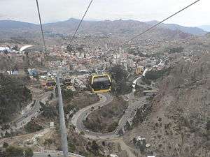
A major goal of the Mi Teleférico project is to improve mobility between La Paz and the neighboring city El Alto, a poorer but growing city with a majority indigenous population. While La Paz is settled in a mountain valley, El Alto is located on the Altiplano plateau some 400 m (1,300 ft) above downtown La Paz, so travel between the two has always been a challenge, and was previously limited to heavily crowded, winding streets.[6] In La Paz, this increased mobility has served to reduce an ongoing culture clash between Bolivia's socioeconomic classes and ethnic groups.
References
- 1 2 3 4 "Almanaque Mi Teleférico" [Mi Teleférico Calendar] (PDF) (in Spanish). Empresa Estatal de Transporte por Cable "Mi Teleférico". Retrieved February 2, 2015.
- ↑ "Evo Morales inaugura teléferico que une La Paz y El Alto" [Evo Morales inaugurates cable car to connect La Paz and El Alto]. Prensa Latina (in Spanish). Havana, Cuba. May 30, 2014.
- ↑ Metcalfe, John (April 11, 2014). "Bolivia Deploys the World's Largest System of Cable Cars". CityLab. Atlantic Media.
- ↑ "Bolivia consolida la red de teleférico más largo del mundo" [Bolivia establishes world's longest cable car network]. teleSUR (in Spanish). December 3, 2014.
- 1 2 "Evo autoriza la construcción de seis nuevas líneas de teleférico en La Paz y El Alto" [Evo authorizes construction of six new cable car lines in La Paz and El Alto]. Página Siete (in Spanish). La Paz, Bolivia. January 26, 2016.
- 1 2 Neuman, William (August 16, 2014). "With Subway in the Sky, Valley Meets Plateau". The New York Times. Retrieved February 6, 2015.
- ↑ Villa, Micaela (July 12, 2012). "Evo anuncia millonaria inversión para teleférico La Paz-El Alto" [Evo announces multi-million-dollar investment in La Paz-El Alto cable car]. La Razón (in Spanish). La Paz, Bolivia.
- ↑ "Ficha técnica del proyecto teleférico" [Cable car project technical datasheet] (PDF) (in Spanish). Ministerio de Obras Públicas, Servicios y Vivienda, Bolivia. Retrieved January 3, 2014.
- 1 2 Tapia, Guadalupe (January 27, 2015). "Elevan a 6 las líneas de fase II del teleférico; la Azul es la más larga" [Number of lines in cable car's phase two raised to six; Yellow to be the longest]. La Razón (in Spanish). La Paz, Bolivia.
- 1 2 Chu, Nick (February 18, 2016). "La Paz: Purple Line Starts Construction, Silver Line Announced". The Gondola Project. Creative Urban Projects. Retrieved February 21, 2016.
- 1 2 Revollo Endara, María Fernanda (17 November 2016). "Línea azul de Mi Teleférico se inaugurará el 6 de marzo de 2017" [Mi Teleférico Blue Line to open 6 March 2017]. Abya Yala Digital (in Spanish). Retrieved 28 November 2016.
- ↑ Chuquimia, Leny (March 4, 2015). "Entrega del funicular de Obrajes cierra primera fase del teleférico" [Delivery of Obrajes funicular brings cable car's phase one to an end]. Página Siete (in Spanish). La Paz, Bolivia.
- ↑ "Ministro atribuye al mal uso de los usuarios por las interrupciones que sufrió el teleférico" [Ministry attributes cable car delays to rider misbehavior]. teleSUR (in Spanish). December 3, 2014.
- ↑ Imaña, Gabriela (February 15, 2016). "Caída de árbol saca de su eje cable del teleférico, hay heridos" [Fallen tree dislocates Mi Teleférico cable, injuries reported]. La Razón (in Spanish). La Paz, Bolivia.
- ↑ "Acuerdan cambio bimodal entre el teleférico y los buses PumaKatari" [Agreement reached on intermodal transfers between cable car and PumaKatari buses]. La Razón (in Spanish). La Paz, Bolivia. November 18, 2014.
- ↑ "Teleférico La Paz - Android Apps on Google Play". play.google.com. Retrieved 2016-04-03.
- ↑ "Teleférico La Paz en el App Store". App Store. Retrieved 2016-04-03.
- MacGregor, Hilary (December 12, 2015). "La Paz's cable-car system Teleferico a heady ride that bridges Bolivia's values". Los Angeles Times.
External links
| Wikimedia Commons has media related to Mi Teleferico. |
- MiTeleférico - official website (Spanish)
- Mobile App Teleférico La Paz website - http://telefericolapaz.nedixgroup.com/ (Spanish)