Mi'ilya
Mi'ilya
| ||
|---|---|---|
| Hebrew transcription(s) | ||
| • ISO 259 | Miˁilyaˀ | |
| • Also spelled | Malia (unofficial) | |
|
King's castle | ||
| ||
 Mi'ilya | ||
| Coordinates: 33°1′30.57″N 35°15′34.41″E / 33.0251583°N 35.2595583°ECoordinates: 33°1′30.57″N 35°15′34.41″E / 33.0251583°N 35.2595583°E | ||
| Grid position | 174/269 PAL | |
| District | Northern | |
| Founded | Prior to 1160[1] | |
| Government | ||
| • Type | Local council (from 1957) | |
| Area | ||
| • Total | 1,365 dunams (1.365 km2 or 337 acres) | |
| Population (2015)[2] | ||
| • Total | 3,208 | |
| Name meaning | “The High place”[3] | |

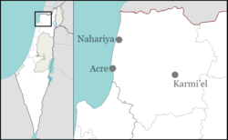
Mi'ilya (Arabic: معليا, Hebrew: מִעִלְיָא) is an Arab local council in the western Galilee in the Northern District of Israel. Its name during the Kingdom of Jerusalem era in Galilee was Castellum Regis.[1] In 2015 it had a population of 3,208, all of whom are Melkite Greek Catholics. The town is located immediately to the northwest of Ma'alot-Tarshiha.
History
Archaeological excavations in Mi'ilya gives indication of inhabitation from the Late Bronze Age and Iron Age, as well as Hellenistic, Roman, Byzantine, Crusader, Mamluk and Ottoman periods.[4]
In the Crusader era, Mi'ilya was first mentioned in 1160, when it and several surrounding villages was transferred to a Crusader named Iohanni de Caypha (Johannes of Haifa).[5]
In 1179 Viscountess Petronella of Acre sold the houses, vineyards and gardens of Mi'ilya to Count Jocelyn III, uncle of Baldwin IV,[6] and in 1183, Baldwin IV transferred a house that he had bought in Mi'ilya from the scribe, John of Bogalet, in addition to other possessions in the vicinity of Mi'ilya to the same uncle, Jocelyn III.[7]
However, already in 1187 Mi'ilya (including its castle) fell to Saladin.[8]
In 1188 it was granted by Conrad of Montferrat to the Pisans who were defending Acre,[9] but it is unclear if they ever took control of it.
In 1220 Jocelyn III´s daughter Beatrix de Courtenay and her husband Otto von Botenlauben, Count of Henneberg, sold Mi'ilya to the Teutonic Knights on the 31st of May, for the sum of 7000 marks of silver. This included Mi'ilya with its dependencies, and a third of the fief of St. George.[10][11]
In 1228 Jocelyn III´s grandson James of Mandale sold his part to the Teutonic Knights.[12]
Between 1220 and 1243, the Teutonic Knights bought a number of properties from private owners around the castle.[13]
Another document from the year 1257 mentions a house and other property in Mi‘ilya that belonged to the Bishop of ‘Akko.[14]
By 1268/71 Mi'ilya was conquered by Baibars.[15]
Ottoman period
In 1596, Mi'ilya appeared in Ottoman tax registers as being in the Nahiya of Akka of the Liwa of Safad. It had a population of 15 Muslim households and 2 Christian households and paid taxes on wheat, barley, olives, and goats or beehives.[16]
In 1881, Mi'ilya was described as being a large and well-built village of stone, containing 450 Christians, surrounded by olives and arable land.[17]
Mandatory period
In the 1922 census of Palestine conducted by the British Mandatory authorities, Mi'ilya had a population of 442 inhabitants; 429 Christians and 13 Muslims.[18] Of the Christians, 3 were Orthodox, 2 Catholics and 424 Greek Catholic (Melchite).[19] The population had increased in the 1931 census to 579; 553 Christians, 25 Muslims and 1 Druse, in a total of 138 houses.[20]
By 1945, the population had increased to 790 Christians and 110 Muslims,[21] while the total land area was 29,084 dunams, according to an official land and population survey.[22] Of this, 1,509 dunams were allocated for plantations and irrigable land, 2,883 for cereals,[23] while 123 dunams were classified as built-up areas.[24]
State of Israel
In the early part of 1948 the village suffered from food shortages and harassment from neighbouring Jewish areas. It was captured by the Israel Defense Forces during Operation Hiram at the end of October. After a short fight, most of population fled into the countryside. The following day the local IDF commander allowed them to return to their homes. This was one of the few occasions when villagers were allowed back into their villages after they had left.[25] In January 1949 some villagers from Mi'ilya were expelled to Jenin, they complained of being robbed by Israeli soldiers whilst being deported. The Ministry for Minority Affairs reported that a further 25 villagers were expelled in March being suspected of passing information to the enemy.[26] Mi'ilya was recognized as a local council in 1957. The Arab population remained under Martial Law until 1966.
Transportation
Mi'ilya is located on the Highway 89 which connects Nahariya with Elifelet via Safed.
Notable buildings
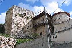
King's castle
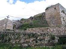
Kings castle, was first noted in Crusader sources in 1160.[27]
By 1179 the castle had apparently been rebuilt, as it was then called Castellum Novo.[6] In 1182, Baldwin IV granted the castle to his uncle, Jocelyn III. At this time it was called "The new castle in the mountains of Acre".[28]
By 1187, the castle fell to Saladin, but was soon back in Crusader control. In the 1220, ownership passed to the Teutonic Knights. However, the importance of the castle of Mi'ilya was by this time superseded by the Montfort Castle.[10]
The Arab geographer, Al-Dimashqi, noted the "fine castle", and that close to it was a very pleasant valley, where musk-pears and large citrons were grown.[29]
Victor Guérin found in the 19th century that “on the highest part of the hill we remark the remains of an ancient fortress, flanked by four square towers; considerable portions remain, showing that it was built of regular blocks, some levelled plane and some embossed; the latter were reserved for the angles. The ruins and interior of this fortress are now inhabited by about twenty families, which have built their little habitations in the midst of the debris.”[30]
Church of St Mary Magdalen
Mariti passed by in 1761, and noted "an ancient church, in which the Catholic Greeks somes´times perform divine service."[31]
Victor Guérin visited in 1875, and noted that "The Greeks had just rebuilt their church on the foundations of another much more ancient, which was decorated with monolithic columns with capitals imitating Corintian.“[32]
See also
- Arab localities in Israel
- Arab Christians
- Journal of Palestine Studies. Volume 1 #4. Summer 1972. Shoufani, Elias The fall of a village.
References
- 1 2 Ellenblum, 2003, p. = riHMZiH_Te4C&pg = PA41 41
- ↑ "List of localities, in Alphabetical order" (PDF). Israel Central Bureau of Statistics. Retrieved 16 October 2016.
- ↑ Palmer, 1881, p. 52
- ↑ Porat, 2009, Mi‘ilya, the Church Square Preliminary Report
- ↑ Strehlke, 1869, pp. 2-3, No. 2; Cited in Röhricht, 1893, RRH, p. 89, No. 341; Cited in Pringle, 1993, p. 30 and in Ellenblum, 2003, p. 41
- 1 2 Strehlke, 1869, pp. 11-12, No. 11; cited in Röhricht, 1893, RRH, p. 156, No. 587; cited in Pringle, 1997, p. 71
- ↑ Strehlke, 1869, p. 16, No. 17; cited in Röhricht, 1893, RRH, pp. 165-6, No. 625; Cited in Pringle, 1998, p. 30
- ↑ Abu'l-Fida, in R.H.C. Or. I., p. 56, Ali ibn al-Athir, 1231, Kamel-Altevarykh, as given in R.H.C. Or. I., p. 690 and Al-Maqrizi, all cited in Pringle, 1998, p. 30
- ↑ Röhricht, 1893, RRH, p. 180, No. 674, cited in Pringle, 1998, p. 30
- 1 2 Strehlke, 1869, pp. 43-44, No. 53; pp. 47-49, Nos. 58-59; Cited in Röhricht, 1893, RRH, p. 248, No. 934; Cited in Pringle, 1998, p. 30
- ↑ Conder and Kitchener, 1881, SWP I, p. 190
- ↑ Strehlke, 1869, pp. 51-53, No. 63; pp. 53-54, No. 65; Cited in Röhricht, 1893, RRH, p. 263, No. 1002; p. 265, No. 1011; Cited in Pringle, 1998, p. 30
- ↑ Strehlke, 1869, pp. 120-128, No.128; Cited in Röhricht, 1893, RRH, pp. 134-135, No. 510; Cited in Pringle, 1998, p. 31 and Ellenblum, 2003, pp. 42-44
- ↑ Strehlke, 1869, pp. 91-94, No. 112, ; Cited in Röhricht, 1893, RRH, p. 331, No. 1260; cited in Ellenblum, 2003, p. 149 and Khamisy, 2013, Mi‘ilya
- ↑ Pringle, 1997, p. 71
- ↑ Hütteroth and Abdulfattah, 1977, p. 194
- ↑ Conder and Kitchener, 1881, SWP I, p.149
- ↑ Barron, 1923, Table XI, Sub-district of Acre, p. 36
- ↑ Barron, 1923, Table XVI, p. 50
- ↑ Mills, 1932, p. 102
- ↑ Government of Palestine, Village Statistics 1945.
- ↑ Government of Palestine, Department of Statistics. Village Statistics, April, 1945. Quoted in Hadawi, 1970, p. 41
- ↑ Government of Palestine, Department of Statistics. Village Statistics, April, 1945. Quoted in Hadawi, 1970, p. 81
- ↑ Government of Palestine, Department of Statistics. Village Statistics, April, 1945. Quoted in Hadawi, 1970, p. 131
- ↑ Morris, 1987, p. 228
- ↑ Morris, 1987, p. 352
- ↑ Röhricht, 1893, RRH, p. 89, no. 341; cited in Pringle, 1993, p. 30 and in Pringle, 1997, p. 71
- ↑ Strehlke, 1869, pp. 13-15, No. 14; cited in Röhricht, 1893, RRH, pp. 162-163, No. 614, cited in Pringle, 1998, p. 30
- ↑ leStrange, 1890, p.495
- ↑ Guérin, 1880, pp. 60- 61, as translated in Conder and Kitchener, 1881, SWP I, pp. 190-191
- ↑ Mariti, 1792, p. 339; 1769 edition noted in Pringle, 1998, p. 31
- ↑ Guérin, 1880, pp. 60- 61, as translated in Pringle, 1998, p. 31
Bibliography
| Wikimedia Commons has media related to Mi'ilya. |
- Abu-‘Uqsa, Hanaa (2005-06-23). "Mi'ilya Final Report" (117). Hadashot Arkheologiyot – Excavations and Surveys in Israel.
- Barron, J. B., ed. (1923). Palestine: Report and General Abstracts of the Census of 1922. Government of Palestine.
- Conder, Claude Reignier; Kitchener, H. H. (1881). The Survey of Western Palestine: Memoirs of the Topography, Orography, Hydrography, and Archaeology. 1. London: Committee of the Palestine Exploration Fund.
- Ellenblum, Ronnie (2003). Frankish Rural Settlement in the Latin Kingdom of Jerusalem. Cambridge University Press. ISBN 9780521521871.
- Guérin, Victor (1880). Description Géographique Historique et Archéologique de la Palestine (in French). 3: Galilee, pt. 2. Paris: L'Imprimerie Nationale.
- Hadawi, Sami (1970). Village Statistics of 1945: A Classification of Land and Area ownership in Palestine. Palestine Liberation Organization Research Center.
- Hütteroth, Wolf-Dieter; Abdulfattah, Kamal (1977). Historical Geography of Palestine, Transjordan and Southern Syria in the Late 16th Century. Erlanger Geographische Arbeiten, Sonderband 5. Erlangen, Germany: Vorstand der Fränkischen Geographischen Gesellschaft. ISBN 3-920405-41-2.
- Khamisy, Rabei G. (2013-11-21). "Mi'ilya" (125). Hadashot Arkheologiyot – Excavations and Surveys in Israel.
- Mariti, Giovanni (1792). Travels Through Cyprus, Syria, and Palestine; with a General History of the Levant. 1. Dublin: P. Byrne.
- Mills, E., ed. (1932). Census of Palestine 1931. Population of Villages, Towns and Administrative Areas. Jerusalem: Government of Palestine.
- Morris, Benny (1987). The Birth of the Palestinian refugee problem, 1947-1949. Cambridge University Press. ISBN 0-521-33028-9.
- leStrange, Guy (1890). Palestine Under the Moslems: A Description of Syria and the Holy Land from A.D. 650 to 1500. London: Committee of the Palestine Exploration Fund.
- Palmer, E. H. (1881). The Survey of Western Palestine: Arabic and English Name Lists Collected During the Survey by Lieutenants Conder and Kitchener, R. E. Transliterated and Explained by E.H. Palmer. Committee of the Palestine Exploration Fund.
- Porat, Leea (2009-03-09). "Mi'ilya, the Church Square Preliminary Report" (121). Hadashot Arkheologiyot – Excavations and Surveys in Israel.
- Pringle, Denys (1993). The Churches of the Crusader Kingdom of Jerusalem: A-K (excluding Acre and Jerusalem). 1. Cambridge University Press. ISBN 0 521 39036 2.
- Pringle, Denys (1997). Secular buildings in the Crusader Kingdom of Jerusalem: an archaeological Gazetter. Cambridge University Press. ISBN 0521 46010 7.
- Pringle, Denys (1998). The Churches of the Crusader Kingdom of Jerusalem: L-Z (exluding Tyre). 2. Cambridge University Press. ISBN 0 521 39037 0.
- Röhricht, Reinhold (1893). (RRH) Regesta regni Hierosolymitani (MXCVII-MCCXCI) (in Latin). Berlin: Libraria Academica Wageriana.
- Smithline, Howard (2008-12-17). "Mi'iliya Final Report" (120). Hadashot Arkheologiyot – Excavations and Surveys in Israel.
- Stern, Edna J. (2012). "Mi'ilya: Evidence of an early Crusader Settlement". 'Atiqot. 70: 63–76.
- Strehlke, Ernst, ed. (1869). Tabulae Ordinis Theutonici ex tabularii regii Berolinensis codice potissimum. Berlin: Weidmanns.
External links
- Welcome To Mi'ilya
- Survey of Western Palestine, Map 3: IAA, Wikimedia commons
| |||||||
| |||||||