Mettingham
| Mettingham | |
 Mettingham All Saints |
|
 Mettingham |
|
| Population | 211 (2011 Census) |
|---|---|
| OS grid reference | 359 900 |
| District | Waveney |
| Shire county | Suffolk |
| Region | East |
| Country | England |
| Sovereign state | United Kingdom |
| Post town | Bungay |
| Postcode district | NR35 |
| Dialling code | 01986 |
| Police | Suffolk |
| Fire | Suffolk |
| Ambulance | East of England |
| EU Parliament | East of England |
Coordinates: 52°27′25″N 1°28′26″E / 52.457°N 1.474°E
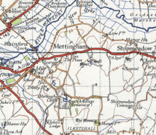
Mettingham is a village near Bungay in NE Suffolk, England, close to the river Waveney which forms the boundary with Norfolk. In the 1870s, Mettingham was described as:
- "a village and a parish in Wangford district, Suffolk. The village stands near the river Waveney, at the boundary with Norfolk, 2 miles E of Bungay r. station; is a scattered place; and has a postoffice under Bungay."[1]
Its church, All Saints, is one of 43 existing round-tower churches in Suffolk.[2] and about a mile to the south, Mettingham Castle comprises the ruins of a moated medieval fortified manor house, with a medieval chantry college in its grounds.[3] The college was founded in 1394 and was dissolved in 1542 at the time of the Dissolution of the Monasteries.
Population

The parish population has varied since 1801. There was a significant increase of 139 between 1801 and 1841, after which there was a long period of decline as agriculture became less labour-intensive.[4] There has been one minor boundary change since 1801,[5] but it was not significant enough to affect the rise in population. However between 1831 and 1841, 36 houses were built,[6] leading to a population increase with more people moving to the area.
As of the 2011 census, Mettingham's population is relatively old: out of the total population of 211 only 34 are below the age of 16;[7] 54 are in the age range 35–54; and 85 are over 55;[7] so that many of the residents are above the national average age of 39.7.[8]

Employment
In 1881 there were 158 adults employed in Mettingham,[9] of whom 62 men and 2 women worked in agriculture[9] as the area is rural farm land.[10] The occupations of most of the women were recorded as "unknown" which means that it is unclear what the main occupation of the women was at that time. The farming was mainly arable, with fields lying fallow in summer in preparation for corn products in the early 1800s, slowly progressing to wheat, barley and beans by the mid 1900s.[11] As of 2011 there were just 22 people employed in agriculture.[12] As infrastructure and communications have improved, the population can now travel further afield to work, giving access to a wider range of occupations, including professional occupations.[12]
Education
Of the 177 residents over age 16 in Mettingham, 41 have no qualifications at all; 6 are in apprenticeships; 28 have between 1–4 GCSEs or equivalent, with another 28 having 5 or more; 18 have 2 or more A-levels; and 47 have education to degree level or above; 4 of the 177 are still in full-time education.[13] Those under 16 are still in compulsory education. There are 7 primary schools and 2 secondary schools within 3 miles of Mettingham, all of which are in the town of Bungay. Bungay High School provides a sixth form for 16- to 18-year-olds taking A-levels.[14]
All Saints Church
All Saints is one of 178 round tower churches in East Anglia[2] from the Norman period.[15] It is a Grade I listed building which was restored in 1898.[16] Round tower churches in the UK, with a few exceptions, are only found in East Anglia. It is widely accepted that the tower was built as a bell tower[2] with flint as the main construction material; but stone is also used in the main building construction,[16] This is due to Mettingham's location: flint was cheaper and much more widely available in East Anglia, whereas stone had to be transported from a distance.[17]
In 2012, All Saints Church was threatened with closure due to the theft of £16,000 worth of lead from its roof: there was insufficient money for repairs on top of daily running costs.[18] The money was raised to replace the lead, but just two years later, in October 2014, a 15m x 10m stretch of lead was again taken. A cheaper material was used to fix the roof to avoid another recurrence.[19]
Transport
Mettingham has very limited public transport. It has a bus service with 3 morning stops and one evening stop at the Rectory Lane Junction on the B1062 on Monday to Saturday, but no Sunday service.[20] The closest railway station is Beccles, about 4 miles away.[21]
References
- ↑ Wilson, John Marius (1870). Imperial Gazetteer of England and Wales. Edinburgh: A. Fullerton & Co. Retrieved 27 January 2015.
- 1 2 3 Hart, Stephen. "Round Tower Churches". Building Conservation. Retrieved 23 February 2015.
- ↑ Historic England. "Mettingham Castle (391619)". PastScape. Retrieved 15 June 2011.
- ↑ "Total Population". Vision of Britain. Retrieved 27 March 2015.
- ↑ "Boundary Map of Mettingham". Vision of Britain. Retrieved 27 March 2015.
- ↑ "House Ocupancy". Vision of Britain. Retrieved 27 March 2015.
- 1 2 "Adult Lifestage". Neighbourhood Statistics. Office for National Statistics. Retrieved 16 March 2015.
- ↑ "National Population Projections" (PDF). Office for National Statistics. Office for National Statistics. Retrieved 16 March 2015.
- 1 2 Woollard, Matthew. "Mettingham Occupations 1881". Vision of Britain. Retrieved 26 March 2015.
- ↑ "Boundary Map of Land utilisation Mettingham". Vision of Britain. Retrieved 26 March 2015.
- ↑ "Parish: Mettingham" (PDF). Suffolk Heritage. Retrieved 26 March 2015.
- 1 2 "Occupation (minor groups) 2011". Neighbourhood Statisitics. Retrieved 26 March 2015.
- ↑ "Qualifications and Students". Neighbourhood Statistics. Retrieved 24 April 2015.
- ↑ "School and College Performance Tables". Department of Education. Retrieved 24 April 2015.
- ↑ "Mettingham". Nineparishes. Retrieved 27 March 2015.
- 1 2 Historic England. "Details from listed building database (1284396)". National Heritage List for England. Retrieved 27 March 2015.
- ↑ "About Round Tower Churches". Round Towers. Retrieved 23 February 2015.
- ↑ Wood, Richard (17 February 2012). "All Saints Church Mettingham Facing Closure due to Lead Theft". EPD 24. Retrieved 23 February 2015.
- ↑ Hirst, Andrew (7 October 2014). "Mettingham: Vicar 'sickened' by repeated lead theft from All Saints Church says he will no longer replace like for like only to be targeted again". EADT 24. Retrieved 23 February 2015.
- ↑ "Public Transport Journey Planning within Great Britain". Traveline East Anglia. Retrieved 27 March 2015.
- ↑ "Mettingham to Beccles". Google Maps. Retrieved 26 April 2015.
External links
| Wikimedia Commons has media related to Mettingham. |