Mesilla Valley

The Mesilla Valley is a geographic feature of Southern New Mexico and far West Texas. It was formed by repeated heavy spring floods of the Rio Grande.
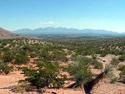
The fertile Mesilla Valley extends from Radium Springs, New Mexico, to the west side of El Paso, Texas.[1] The valley is quite fertile, and is characterized by its few remaining bosques, as well as its native cottonwood trees, and increasingly, by invasive tamarisk, which was introduced in the late 19th century, and is known locally as salt cedar.
Due to the fertile nature of the valley, agriculture is a very important activity in this area. Stahmann Farms owns the world's largest pecan orchard, located south of the city of Las Cruces, New Mexico. Alfalfa, cotton, chile, onions and corn are other important cash crops grown in the Mesilla Valley. The Mesilla Valley is also known for its wine-producing capabilities, which originated with the Spanish exploration into New Mexico.
Further reading
- Leggat, E.R., M.E. Lowry, and J.W. Hood. (1963). Ground-water resources of the lower Mesilla Valley, Texas and New Mexico [U.S. Geological Survey Water-Supply Paper 1669-AA]. Washington, D.C.: U.S. Government Printing Office.
References
- ↑ Chang, C. W. (1953). "Chemical Properties of Alkali Soils in Mesilla Valley, New Mexico". Soil Science. 75 (3): 233–242. doi:10.1097/00010694-195303000-00008. Retrieved January 15, 2013.
Coordinates: 31°47′25″N 106°25′24″W / 31.79028°N 106.42333°W