Merrimack Valley
| Merrimack Valley | |
|---|---|
| Merrimac Valley[1] | |
|
| |
| Location |
|
| Long-axis direction | Northwest-Southeast |
| Geology | |
| Type | River |
| Geography | |
| Bounded by |
White Mountains Plum Island, Massachusetts Atlantic Ocean |
| Population centers |
In New Hampshire: Concord, Manchester, Nashua In Massachusetts: Lowell, Lawrence, Haverhill |
| Traversed by | Interstate 93, Interstate 495, Haverhill Line (MBTA) |
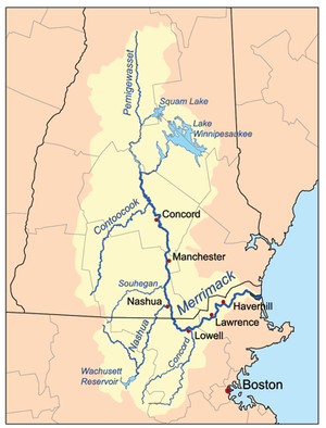
| Watercourses | Merrimack River |
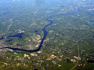
The Merrimack Valley is a bi-state region along the Merrimack River in the U.S. states of New Hampshire and Massachusetts, United States. The Merrimack is one of the larger waterways in the New England region and has helped define the livelihood and culture of those living along it since native times.
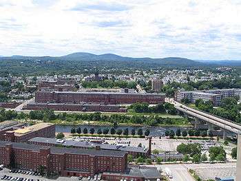
Major cities in the Merrimack Valley include Concord, Manchester and Nashua in New Hampshire, as well as Lowell, Lawrence and Haverhill in Massachusetts. The Merrimack Valley was a major center of the textile industry in America during the 19th century.
Geography and demographics
Massachusetts

The Merrimack Valley area in Massachusetts is a community of towns and cities surrounding the Merrimack River along the New Hampshire border. The cities (marked with italics) and towns in this area are:
The population of the region in 2010 was 631,477 residents, or slightly more than the city of Boston's at the time, and about one tenth of the state.
The Merrimack Valley contains a mixture of 19th-century industrial cities and mill complexes built to take advantage of the river's waterpower, modern suburbs (many built over towns dating from the 17th century), and some relatively rural areas. The western region, including Greater Lowell and Haverhill/Lawrence/Methuen, is generally more urbanized than the eastern region. The entire Merrimack Valley region within Massachusetts is a component of Greater Boston.
Automobile travel through the Massachusetts section of the Merrimack Valley is served primarily by Interstate 495. From Lowell and Lawrence, U.S. Route 3 and Interstate 93, respectively, head north along the valley, joining in Manchester, New Hampshire.
New Hampshire

In New Hampshire, the Merrimack Valley Region is an area of the south-central portion of the state, approximately 35 miles (56 km) wide, centered on the Merrimack River and running from Canterbury[2] south to the Massachusetts border. Henniker marks the western extent, and Nottingham the east. It includes portions of Hillsborough, Rockingham and Merrimack counties, namely the following towns and cities (in italics):
The state capital of Concord, and the state's two largest cities, Manchester and Nashua are located within the valley. Manchester boasts a large regional airport, with scheduled commercial services. Other notable towns and cities in the region include Merrimack, Salem and Derry.
To the east is the Seacoast Region, to the west is the Monadnock Region, and the Lakes Region is to the north.
Interstate 93 bisects the region which is also served by Interstate 293, U.S. Route 3 and many New Hampshire state highways.
History and culture

Pre-contact
The original settlers of the Merrimack Valley were various tribes of the Pennacook Indians. The river provided an easy means of transportation, an exceptional source of salmon as well as other fish, and the land along the river banks was suitable for hunting and sometimes farming. However, much of the soil is full of granite, and the pine forests provide poor soil.
Colonization and the early federal period
The earliest European records of the river date to a French expedition under Pierre du Guast, Sieur de Monts, in 1605. By 1629, the British were moving into the area, and a land grant delineated by the river was made to a Jonathan Wheelwright in 1629.[3]
The city of Newburyport, first settled in 1635, at the river's mouth, became an important shipbuilding center during the colonial era, using lumber floated downriver from the White Mountains. Its prominence was diminished when the Middlesex Canal was completed in the first quarter of the 19th century, allowing lumber to be shipped directly downriver from the White Mountains to Charlestown, Massachusetts, and improving connections between Boston and the Merrimack Valley. Prior to this time, other small canals had been built around falls and rapids to make the Merrimack navigable, such as the Pawtucket Canal at East Chelmsford, which became Lowell.
Industrial revolution
While the Merrimack had been used for small manufacturing concerns for decades, in the early 1820s, a group of investors from Boston founded the city of Lowell, to take advantage of the 32-foot (9.8 m) drop of the Merrimack over the Pawtucket Falls. Lowell, the first large-scale planned textile center in America, remained the nation's largest into the 1850s. Textile production spread up and down the Merrimack Valley in both states for the next century, but eventually was eclipsed after the Second World War.
Manchester's Amoskeag Mills was once the largest cotton textile plant in the world. Other major textile companies based in the Merrimack Valley included the Merrimack Manufacturing Company in Lowell, the American Woolen Company in Lawrence (headquarters moved to Andover in 1919), Pemberton Mill in Lawrence, and the Nashua Manufacturing Company in its namesake city. Lawrence was the site of the Bread and Roses strike, a landmark event in the history of labor relations in the United States.
Modern era
After World War II, the textile industry collapsed rapidly. After a few decades of stagnation, the "Massachusetts Miracle" came to the valley, bringing the headquarters of Wang Laboratories to Tewksbury, then Lowell. Apollo Computer located in Chelmsford and Nashua Corporation in Nashua moved beyond printing to computer products. The defense industry, for example, Raytheon in various sites and Sanders Associates in Nashua, became a major local employer. Increased development pressure from Greater Boston and the proliferation of the automobile pushed development outside of Massachusetts Route 128 to Interstate 495 and up Routes 3 and 93 into southern New Hampshire, greatly increasing the populations of these communities over the postwar years.
Culture
The Merrimack River Valley is considered the "Valley of the Poets"[4] by some local artists and poets.
Anne Dudley Bradstreet was a founding mother of three towns in the Massachusetts Bay Colony: Boston, Cambridge (then Newtowne), and the original Andover Parish, known now as North Andover, where she lived and wrote for the last half of her life. The first published poet of the New World, she died in North Andover in 1672.[5]
In Haverhill and Amesbury, the family of John Greenleaf Whittier settled. Mr. Whittier was so well thought of during his lifetime, his birthday was celebrated as a national holiday.
Lawrence is the birthplace of actress Thelma Todd, composer/conductor Leonard Bernstein and actor/singer Robert Goulet. Robert Frost spent his teenage years there, as did his future wife, Elinor Miriam White[6] They were co-valedictorians (1892) at Lawrence High School.[7] Actress Bette Davis and the writer Jack Kerouac were born in Lowell.
The Merrimack Valley is one of the few places in the United States where the card game Forty-fives is popular.
The Merrimack Valley's leading boarding schools, such as Phillips Academy in Andover, Massachusetts; the Groton School in Groton, Massachusetts; St. Paul's School in Concord, New Hampshire; and The Governor's Academy in Newbury, Massachusetts, provide cultural institutions to the public, including the Addison Gallery of American Art and the Robert S. Peabody Museum of Archaeology in Andover and the Christopher Brodigan Gallery and the de Menil Gallery in Groton.
Economy
Massachusetts
The Merrimack Valley in Massachusetts is divided into three New England city and town areas (NECTAs) by the U.S. Office of Management and Budget: Lowell-Billerica-Chelmsford, MA-NH; Lawrence-Methuen-Salem, MA-NH; and Haverhill-North Andover-Amesbury, MA-NH. Most large employers are in the sectors of health care and higher education.[8][9] Institutes of higher learning include Hockey East rivals UMass Lowell and Merrimack College. The region was once a technology hub, reaching its peak during the 1970s and 1980s with corporations such as Wang Laboratories in Lowell among the largest technology employers, though it has since gone defunct. Software company Kronos Incorporated is one of the largest private employers in the region, as is Philips, whose medical division is based in Andover. The defense industry also has had a major presence in the Merrimack Valley, Massachusetts-based Raytheon has several large plants and offices in the Merrimack Valley, and BAE Systems Inc. also employs many people. Due to its proximity to Boston, the region also serves as a bedroom community for employers in Boston. Many major highways (including I-93, I-95, and US 3) and several heavily used lines of the MBTA Commuter Rail system provide easy access to the city from the Merrimack Valley.
New Hampshire
While the textile industry that served as the underpinning of the Merrimack Valley has disappeared, the region has since transferred to other economic activities. Sanders Associates, a major defense contractor based in Nashua has, through several mergers and acquisitions, become a division of BAE Systems Inc. and is one of the regions largest employers. Technology companies also have a large presence in the region, including mobile phone company Verizon, which is the largest private employer in Manchester. The financial industry is also a major employer, with Lincoln Financial in Concord and Fidelity Investments in Merrimack among the largest private employers.
Attractions include:
- Bear Brook State Park
- Canobie Lake Park, an amusement park
- McAuliffe-Shepard Discovery Center, a planetarium/air and space museum
- New Hampshire Historical Society Museum
- New Hampshire State House
- Pawtuckaway State Park
- Robert Frost Farm, a state historic park
- Silver Lake State Park
Institutions of higher education include:
- Daniel Webster College, Nashua
- New Hampshire Institute of Art, Manchester
- Rivier University, Nashua
- Saint Anselm College, Goffstown
- Southern New Hampshire University, Manchester and Hooksett
- University of New Hampshire at Manchester
- University of New Hampshire School of Law, Concord
- New England College, Henniker
See also
- Merrimack Valley Conference, a high school athletic conference in Massachusetts
References
- ↑ Quarstein, John V. (2012). The CSS Virginia: Sink Before Surrender. Charleston, SC: The History Press. p. 266.
- ↑ "New Hampshire Regions: Merrimack Valley [map]". Visit NH. NH Division of Travel and Tourism Development. Retrieved January 28, 2016.
- ↑ Pendergast, John (1996). The Bend in the River. Tyngsborough, Massachusetts: Merrimack River Press. p. 35-36. ISBN 978-0962933806.
- ↑ "Valley of the Poets Walking Tour". annebradstreet.org. March 22, 2013. Retrieved January 28, 2016.
- ↑ "Charlotte Gordon - Mistress Bradstreet". Charlottegordonbooks.com. Retrieved 2015-03-13.
- ↑ "Elinor Miriam White Frost (1873 - 1938) - Find A Grave Memorial". Findagrave.com. Retrieved 2015-03-13.
- ↑ "Lawrence, Massachusetts, 1885 - 1900". Places and Poetry: A Biography. The Friends of Robert Frost. Retrieved January 28, 2016.
- ↑ Commonwealth of Massachusetts. "Largest 100 Employers in Lowell-Billerica-Chelmsford, MA-NH NECTA Division". Executive Office of Labor and Workforce Development. Retrieved 2011-03-20.
- ↑ Commonwealth of Massachusetts. "Largest 100 Employers in Lawrence-Methuen-Salem, MA-NH NECTA Division". Executive Office of Labor and Workforce Development. Retrieved 2011-03-20.
!["New Hampshire Regions: Merrimack Valley [map]"](http://www.visitnh.gov/library/images/regions/merrimack-valley.gif)
External links
- Merrimack Valley Economic Development Council (Massachusetts)
- Merrimack Valley Magazine
- Merrimack Valley Dining of Massachusetts
Boston (capital) | |
| Topics |
|
| Society | |
| Regions | |
| Counties | |
| Cities |
|