Merrickville–Wolford
| Merrickville-Wolford | |
|---|---|
| Village (lower-tier) | |
| Village of Merrickville-Wolford | |
|
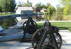
Rideau Canal locks in Merrickville | |
| Motto: Jewel of the Rideau. | |
 Merrickville-Wolford | |
| Coordinates: 44°55′N 75°50′W / 44.917°N 75.833°WCoordinates: 44°55′N 75°50′W / 44.917°N 75.833°W | |
| Country |
|
| Province |
|
| County | Leeds and Grenville |
| Settled | 1794 |
| Incorporated | January 1, 1998 (Merrickville-Wolford) |
| Government | |
| • Mayor | Dave Nash |
| • Governing Body | Council of the Village of Merrickville-Wolford |
| • Federal riding | Leeds—Grenville |
| • Prov. riding | Leeds—Grenville |
| Area[1] | |
| • Land | 214.49 km2 (82.82 sq mi) |
| Population (2011)[1] | |
| • Total | 2,850 |
| • Density | 13.3/km2 (34/sq mi) |
| Time zone | Eastern (EST) (UTC-5) |
| • Summer (DST) | Eastern (EDT) (UTC-4) |
| Area code(s) | 613 |
| Website | village.merrickville-wolford.on.ca |
Merrickville–Wolford is a village-status municipality in Eastern Ontario, Canada, located in Leeds and Grenville United Counties. It spans both shores of the Rideau River.
The current municipality was incorporated on January 1, 1998, by amalgamating the former village of Merrickville with the former township of Wolford.
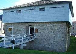
The Rideau Canal locks at Merrickville with three locks have a total lift of twenty five feet. On the south side of the locks there is the old blockhouse, which has been restored by Parks Canada as a tourist site and museum operated by the Merrickville and District Historical Society.
In the last two decades, the region has seen a boom in the local economy mostly related to increased tourism. It is famous for its local crafts people and artists.
History
William Merrick founded the village of Merrickville in 1794. Attracted to the site by waterpower, he constructed a dam across the river and then built grist, saw and carding mills. It was not long before a community sprang up around the milling activity. In 1821, Merrick built a stone house overlooking his mills.
When the construction crews arrived in 1827 to build the Rideau Canal, the village of Merrick's Mills, as it was then known, was a thriving community of about 300. A plaque was erected by the Merrickville and District Historical Society in remembrance of an unknown number of persons who were buried in the McGuigan Cemetery between the years 1800 and 1900; Many died of pestilence, principally malaria, during the construction of the Rideau Canal.
Unlike most of the pre-canal sites, Merrick's Mills was not destroyed by canal construction. After the canal was completed, the excess water once again turned the wheels of the mills and the improved transportation system caused a surge in commercial activity in the village. By 1851, Merrick's Mills was an impressive industrial centre.
Merrick's Mills continued to thrive into the mid-1860s. The end of the community's industrial growth is closely related to the decline of the commercial phase of the Rideau canal. The rise of the nearby town of Smiths Falls as a major railway hub displaced Merrick's Mills as an industrial leader in the region. Despite the decline, some industry continued in the community. In 1915 a power company was formed at Merrickville to provide electricity for the mills and a foundry, and the woolen mill continued to function until 1954.
Communities
In addition to Merrickville, the village comprises the smaller communities of Carleys Corners, Eastons Corners, Hemlock Corners, Jasper, Snowdons Corners, Wolford Centre, Wolford Chapel and Yule.
Demographics
| Canada census – Merrickville–Wolford community profile | |||
|---|---|---|---|
| 2011 | 2006 | 2001 | |
| Population: | 2850 (-0.6% from 2006) | 2867 (2.0% from 2001) | 2812 (6.9% from 1996) |
| Land area: | 214.49 km2 (82.82 sq mi) | 213.77 km2 (82.54 sq mi) | 213.81 km2 (82.55 sq mi) |
| Population density: | 13.3/km2 (34/sq mi) | 13.4/km2 (35/sq mi) | 13.2/km2 (34/sq mi) |
| Median age: | 45.1 (M: 44.7, F: 45.5) | 42.8 (M: 41.1, F: 44.6) | |
| Total private dwellings: | 1248 | 1195 | 1118 |
| Median household income: | $54,036 | $56,036 | |
| References: 2011[2] 2006[3] 2001[4] | |||
Population trend:[5]
- Population in 2006: 2867 (2001 to 2006 population change: 2.0%)
- Population in 2001: 2812
- Population in 1996:
- Merrickville Village: 1027
- Wolford Township: 1603
- Population in 1991:
- Merrickville Village: 989
- Wolford Township: 1438
Mother tongue:[6]
- English as first language: 92.4%
- French as first language: 3.9%
- English and French as first language: 0%
- Other as first language: 3.7%
Attractions
Merrickville was acknowledged as Canada's Most Beautiful Village by Communities in Bloom in 1998, as its charming streets are lined with heritage architecture, artists' studios, specialty boutiques and restaurants. There is a thriving artisan community with more than 30 artists in the area.
Merrickville has more than 100 historic and heritage properties. One of the oldest settlements along the Rideau canal, a major feature in the village is the set of three locks on the Rideau Canal. The locks are adjacent to the Blockhouse, built in 1832 to guard the locks against potential American attacks.
The Blockhouse, a National Historic Site of Canada,[7][8] was built by Lt. Col. John By as part of a chain of four blockhouses for the defense of the Rideau Canal. The Blockhouse Museum is open during peak summer season. Near the locks is the Industrial Heritage Complex Museum, the site of the original mills.
Merrickville was for many years the home of railway contractor Harry Falconer McLean, and his house built by Aaron Merrick, the son of town founder William Merrick, can still be seen in the village. A pub is now named after Harry McLean, although it is not located in his house.
The Merrickville Artists Guild Studio Tour, the last weekend of September and first weekend in October, is Eastern Ontario's original artists' tour, and features the work of over 30 artists each year.
Gardening enthusiasts can stroll through the Rideau Woodland Ramble, declared one of Canada's Top Garden Destinations (voted one of Canada's Top nurseries in Canadian Gardening Magazine) with a huge range of rare and exotic plants, trees and shrubs located just south of the village of Burritt's Rapids.
Every summer there is the Merrickville Fair which brings a Midway, 4-H Livestock Show events, Agricultural Displays and other attractions to the town. In July there is also a Vintage Car Show that brings exhibitors from central and eastern Canada and the United States.
There are a number of bed and breakfast locations at Merrickville, and restaurants including pubs, cafés, and diners.
See also
References
- 1 2 "Merrickville-Wolford census profile". 2011 Census of Population. Statistics Canada. Retrieved 2012-02-15.
- ↑ "2011 Community Profiles". Canada 2011 Census. Statistics Canada. July 5, 2013. Retrieved 2012-02-15.
- ↑ "2006 Community Profiles". Canada 2006 Census. Statistics Canada. March 30, 2011. Retrieved 2012-02-15.
- ↑ "2001 Community Profiles". Canada 2001 Census. Statistics Canada. February 17, 2012. Retrieved 2012-02-15.
- ↑ Statistics Canada: 1996, 2001, 2006 census
- ↑ Statistics Canada 2006 Census - Merrickville-Wolford community profile
- ↑ Merrickville Blockhouse, Directory of Designations of National Historic Significance of Canada
- ↑ Merrickville Blockhouse. Canadian Register of Historic Places.
External links
| Wikimedia Commons has media related to Merrickville-Wolford. |
| Wikivoyage has a travel guide for Merrickville. |
- Village of Merrickville-Wolford
- Merrickville and District Historical Society
- Merrickville Chamber of Commerce
 |
Smiths Falls Rideau Lakes |
Montague | Ottawa | |
| Elizabethtown-Kitley | |
North Grenville | ||
| ||||
| | ||||
| Augusta |