Merriam, Kansas
| Merriam, Kansas | |
|---|---|
| City | |
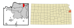 Location within Johnson County and Kansas | |
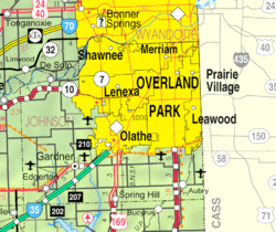 KDOT map of Johnson County (legend) | |
| Coordinates: 39°1′15″N 94°41′38″W / 39.02083°N 94.69389°WCoordinates: 39°1′15″N 94°41′38″W / 39.02083°N 94.69389°W | |
| Country | United States |
| State | Kansas |
| County | Johnson |
| Incorporated | 1950 |
| Government[1] | |
| • Mayor | Ken Sissom |
| Area | |
| • Total | 4.32 sq mi (11.19 km2) |
| • Land | 4.32 sq mi (11.19 km2) |
| • Water | 0 sq mi (0 km2) |
| Elevation | 909 ft (277 m) |
| Population (2010)[2] | |
| • Total | 11,003 |
| • Estimate (2012[3]) | 11,174 |
| • Density | 2,500/sq mi (980/km2) |
| Time zone | CST (UTC-6) |
| • Summer (DST) | CDT (UTC-5) |
| ZIP codes | 66202-66204 |
| Area code | 913 |
| FIPS code | 20-46000 [4] |
| GNIS ID | 0479213 [5] |
| Website | Merriam.org |
Merriam /ˈmɛriəm/ is a city in Johnson County, Kansas, United States, and part of the Kansas City Metropolitan Area. As of the 2010 census, the city population was 11,003.[6] It is bordered by the cities of Overland Park to the east and south, Shawnee to the west, and Kansas City, Kansas to the north (in Wyandotte County); the city of Lenexa is less than a mile to the southwest. Merriam is included in the Shawnee Mission postal designation.
History
Merriam was incorporated as a third class city on October 28, 1950, and established second class city status on January 18, 1957.[7]
The city was named in honor of Charles Merriam, a one-time secretary/treasurer of the then Kansas City, Fort Scott and Gulf railroad which ran through the area.[8][9]
Geography
Merriam is located at 39°1′15″N 94°41′38″W / 39.02083°N 94.69389°W (39.020888, -94.693784).[10] The city straddles approximately three miles of Interstate 35 from less than a mile southwest of its junction with Interstate 635 south to 75th Street. Shawnee Mission Parkway, an east-west road, nearly bisects the city. U.S. Routes 59 and 69 follow the Interstate to the south of the city and follow Shawnee Mission Parkway to the east from its junction with the Interstate. Turkey Creek, following a roughly parallel path to the Interstate, flows through the city.
According to the United States Census Bureau, the city has a total area of 4.32 square miles (11.19 km2), all of it land.[11]
Demographics
| Historical population | |||
|---|---|---|---|
| Census | Pop. | %± | |
| 1960 | 5,084 | — | |
| 1970 | 10,851 | 113.4% | |
| 1980 | 10,794 | −0.5% | |
| 1990 | 11,821 | 9.5% | |
| 2000 | 11,008 | −6.9% | |
| 2010 | 11,003 | 0.0% | |
| Est. 2015 | 11,288 | [12] | 2.6% |
| U.S. Decennial Census | |||
2010 census
As of the census[2] of 2010, there were 11,003 people, 4,900 households, and 2,788 families residing in the city. The population density was 2,547.0 inhabitants per square mile (983.4/km2). There were 5,224 housing units at an average density of 1,209.3 per square mile (466.9/km2). The racial makeup of the city was 83.4% White, 6.1% African American, 0.5% Native American, 2.6% Asian, 0.1% Pacific Islander, 3.9% from other races, and 3.6% from two or more races. Hispanic or Latino of any race were 10.7% of the population.
There were 4,900 households of which 25.3% had children under the age of 18 living with them, 41.6% were married couples living together, 11.3% had a female householder with no husband present, 4.0% had a male householder with no wife present, and 43.1% were non-families. 34.9% of all households were made up of individuals and 9.4% had someone living alone who was 65 years of age or older. The average household size was 2.21 and the average family size was 2.88.
The median age in the city was 37.4 years. 20.1% of residents were under the age of 18; 8.4% were between the ages of 18 and 24; 30.9% were from 25 to 44; 26.6% were from 45 to 64; and 13.9% were 65 years of age or older. The gender makeup of the city was 47.8% male and 52.2% female.
2000 census
As of the U.S. Census in 2000,[4] there were 11,008 people, 4,839 households, and 2,903 families residing in the city. The population density was 2,550.9 people per square mile (983.8/km²). There were 5,042 housing units at an average density of 1,168.4 per square mile (450.6/km²). The racial makeup of the city was 89.24% White, 4.02% Black or African American, 0.42% Native American, 2.09% Asian, 0.02% Pacific Islander, 1.95% from other races, and 2.25% from two or more races. Hispanic or Latino of any race were 5.41% of the population. The ancestral makeup was 21.9% German, 12.9% English, 11.5% Irish and 7.7% American.
There were 4,839 households out of which 26.3% had children under the age of 18 living with them, 46.8% were married couples living together, 9.7% had a female householder with no husband present, and 40.0% were non-families. 33.3% of all households were made up of individuals and 7.6% had someone living alone who was 65 years of age or older. The average household size was 2.23 and the average family size was 2.86.
In the city the population was spread out with 21.7% under the age of 18, 8.3% from 18 to 24, 34.0% from 25 to 44, 23.8% from 45 to 64, and 12.2% who were 65 years of age or older. The median age was 36 years. For every 100 females there were 92.6 males. For every 100 females age 18 and over, there were 90.9 males.
As of 2000 the median income for a household was $48,455, and the median income for a family was $54,639. Males had a median income of $37,358 versus $29,815 for females. The per capita income for the city was $23,988. About 4.3% of families and 6.2% of the population were below the poverty line, including 9.7% of those under age 18 and 7.1% of those age 65 or over.
Economy
Seaboard Corporation is based in Merriam.
IKEA announced the construction and opening of an IKEA store at Johnson Drive & Interstate 35. It added between 200-500 jobs in Spring 2015.
Top employers
According to Merriam's 2010 Comprehensive Annual Financial Report,[13] the top employers in the city were:
| # | Employer | # of Employees |
|---|---|---|
| 1 | Shawnee Mission Medical Center | 2,700 |
| 2 | GE Money | 530 |
| 3 | First Student | 330 |
| 4 | Hendrick Chevrolet/Toyota | 281 |
| 5 | Seaboard Corporation | 190 |
| 6 | Shawnee Mission School District | 181 |
| 7 | CarMax | 149 |
| 8 | The Home Depot | 143 |
| 9 | IBT | 142 |
| 10 | Aristocrat Motors | 140 |
Libraries
Johnson County Library serves residents of Merriam. The library's Antioch branch is located at the intersection of Shawnee Mission Parkway and Antioch road. At one time, this branch served as the headquarters for the library system.
References
- ↑ Merriam City Council
- 1 2 "American FactFinder". United States Census Bureau. Retrieved 2012-07-06.
- ↑ "Population Estimates". United States Census Bureau. Retrieved 2013-05-29.
- 1 2 "American FactFinder". United States Census Bureau. Retrieved 2008-01-31.
- ↑ "US Board on Geographic Names". United States Geological Survey. 2007-10-25. Retrieved 2008-01-31.
- ↑ "2010 City Population and Housing Occupancy Status". U.S. Census Bureau. Retrieved March 6, 2011.
- ↑ "Our City". City of Merriam. Retrieved 2006-07-23.
- ↑ http://www.kshs.org/kansapedia/johnson-county-kansas/15301
- ↑ http://www.exploremerriam.com/MERRIAM/index.htm#History
- ↑ "US Gazetteer files: 2010, 2000, and 1990". United States Census Bureau. 2011-02-12. Retrieved 2011-04-23.
- ↑ "US Gazetteer files 2010". United States Census Bureau. Retrieved 2012-07-06.
- ↑ "Annual Estimates of the Resident Population for Incorporated Places: April 1, 2010 to July 1, 2015". Retrieved July 2, 2016.
- ↑ City of Merriam CAFR
External links
- Official sites
- History
Municipalities and communities of Johnson County, Kansas, United States | ||
|---|---|---|
| Cities | 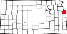 | |
| Unincorporated communities | ||
| Townships | ||
| Footnotes | ‡This populated place also has portions in an adjacent county or counties | |
Kansas City metropolitan area's cities and counties | ||
|---|---|---|
| Central city |  | |
| Largest cities (over 100,000 in 2000) | ||
| Medium-sized cities (10,000 to 100,000 in 2000) | ||
| Smaller Cities (between 5,000 and 9,900 in 2010) | ||
| Counties | ||