Mergui Archipelago

The Mergui Archipelago (also Myeik Archipelago or Myeik Kyunzu; Burmese: မြိတ်ကျွန်းစု) is an archipelago in far southern Myanmar (Burma) and is part of the Tanintharyi Region. It consists of more than 800 islands, varying in size from very small to hundreds of square kilometres, all lying in the Andaman Sea off the western shore of the Malay Peninsula near its landward (northern) end where it joins the rest of Indochina. Occasionally the islands are referred to as the Pashu Islands because the Malay inhabitants are locally called Pashu.
Environment

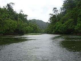
Geologically, the islands are characterized mainly by limestone and granite. They are generally covered with thick tropical growth, including rainforest, and their shorelines are punctuated by beaches, rocky headlands, and in some places, mangrove swamps. Offshore are extensive coral reefs.
The archipelago's virtual isolation from most of mankind's influence on the natural environment has given the islands and the surrounding waters of the Andaman Sea a great diversity of flora and fauna, contributing to the region's growing popularity as a diving destination, representing megafaunas such as whale sharks and even killer whales.[1]

On the islands themselves, various animals thrive, including deer, monkeys, tropical birds including hornbills, and wild swine. There are even unconfirmed reports of Sumatran rhinoceros on Lanbi, one of the bigger islands, but this has been widely discredited.
Environmental threats to the region include overfishing and also blast fishing. Myanmar's current military government, the "State Peace and Development Council", has not done much to deal with these problems.
Geography
The largest and highest island is King Island at 767 metres [2] across the inland channel from Mergui (Myeik). Other important islands are:
- Auriol Island
- Bentinck Kyun
- Christie Island, the southernmost island of the group
- Daung Kyun
- Kabosa Island
- Kadan Kyun
- Kanmaw Kyun
- Lamin Island
- Lanbi Kyun
- Letsok-aw Kyun
- Mali Kyun, the northernmost island of the group
- Money Island
- Sabi Island
- Saganthit Kyun
- Tenasserim Island
- Thahtay Kyun
- Than Kyun
- Thayawthadangyi
- Zadetkyi
Population
The local people are an ethnic minority called the Moken, sometimes known as sea Gypsies, although this term actually covers several groups in Southeast Asia. They are a sea-dwelling people and they follow a traditional way of life, doing things such as fishing and building boats very much the way they have done for centuries. They can be found living on their traditional boats during the dry season, but usually keep to land in the rainy season. The Moken claim that the islands were detached from the mainland after a great mythological flood.[3]

Violence by the military regime in the archipelago
The Mergui Archipelago is located in Tanintharyi Region, one of the regions heavily impacted by violence during the Burmese Civil War. Violence in the Mergui archipelago has often targeted civilians including the massacres of fishermen and the entire population of the picturesque Christie Island.[4][5]
Tourism
The area was only opened up to foreign tourism in 1997 after negotiations between Myanmar and dive operators from Phuket in Thailand.[6][3] The archipelago's isolation is such that much of it has not even yet been thoroughly explored.[citation needed] The best diving conditions exist from December to April, with whale sharks and manta rays visiting from February to May. A five-star casino and golf resort, the Andaman Club now operates on Thahtay Kyun Island.
In popular culture
- In the 1965 James Bond film Thunderball, Ernst Stavro Blofeld in a disguised voice sends an ultimatum to NATO demanding that they pay SPECTRE a ransom of white flawless diamonds worth £100 million to be deposited in the Mergui Archipelago off the coast of Myanmar.
- The Mergui Archipelago has appeared in several of W.E. Johns's "Biggles" books: Biggles – Air Commodore (1937), Biggles Delivers the Goods (1946), and Biggles and the Lost Sovereigns (1964).
See also
References
- ↑ Sailing Phuket - Catamaran Charter Thailand (April 2, 2014). Close encounter with wild Orcas in the Mergui Archipelago Myanmar. YouTube.
- ↑ Bird, Eric (February 25, 2010). Encyclopedia of the World's Coastal Landforms. Springer Science & Business Media. p. 1085. ISBN 9781402086380.
- 1 2 Roberts, Sophy (April 19, 2013). "The lost world: Myanmar's Mergui islands". Financial Times. Retrieved February 18, 2016.
- ↑ Parry, Richard Lloyd (June 9, 2008). "Defector tells of Burmese atrocity". The Australian. Retrieved February 18, 2016.
- ↑ Fuller, Thomas (April 26, 2012). "As Myanmar Opens Up, Idyllic Islands Remain Unwelcoming". New York Times. Retrieved February 18, 2016.
- ↑ Langfitt, Frank (July 8, 2001). "Excursion to BURMA". Baltimore Sun. Retrieved February 18, 2016.
External links
Coordinates: 12°00′N 98°00′E / 12.000°N 98.000°E