Mercury Island
|
Mercury Island from the air. Note the building on the center left of this photograph for scale. | |
 Mercury Island | |
| Geography | |
|---|---|
| Location | Atlantic Ocean |
| Coordinates | 25°43′09″S 14°49′59″E / 25.719161°S 14.832948°ECoordinates: 25°43′09″S 14°49′59″E / 25.719161°S 14.832948°E |
| Area | 0.03 km2 (0.012 sq mi) |
| Length | 750 m (2,460 ft) |
| Width | 270 m (890 ft) |
| Highest elevation | 38 m (125 ft) |
| Administration | |
|
Namibia | |
| Region | ǁKaras Region |
| Constituency | Lüderitz Constituency |
| Demographics | |
| Population | 2 (2006) |
.jpg)
- not to be confused with the Mercury Islands of New Zealand
Mercury Island is a small rocky island off The Diamond Coast, Namibia. Despite its small size it is recognised by Bird Life and other global conservation groups as one of the Important Bird Areas (IBAs) for its important coastal seabird breeding.
Situation
Mercury Island is situated 800 metres offshore in Spencer Bay, 110 kilometres north of Lüderitz. The island is only 750 metres long (North-South) and about 270 metres wide, reaching a height of 38 metres above the sea. Steep, rocky, without vegetation, covered in a thick layer of bird guano, and riddled with a number of caves (one of which completely bisects the island), Mercury Island's name comes from the shaking that reverberates through the island during westerly wave action. Its nearest neighbour and like bird habitat is Ichaboe Island, about 65 kilometres to the south. Ichaboe and Mercury are the two most important island seabird breeding sites along the Namibian coast. Today the island has a permanent population in the form of a two-person bird research station.[1] The station sits on the remains of a bird guano mining dock on the northeast side of the island.[2]
Mercury Island's three hectares are home to 16000 penguins, 1200 gannets, and 5000 cormorants,[3] which range tens of kilometres out to sea, and return to the island to breed.[4]
Importance to wildlife
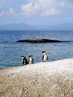
Together with Ichaboe Island, Halifax Island and the Possession Island, these islands support the entire Namibian breeding population of Cape gannets Morus capensis, 96% of the Namibian population of the endangered African penguin Spheniscus demersus, and nearly one quarter of the global breeding population of crowned cormorants Microcarbo coronatus.[5] Approximately 80% of the global population of the endangered bank cormorant Phalacrocorax neglectus breeds on Mercury Island and in the Ichaboe Islands. Migrating whales such as humpback whales and recovering southern right whales also visit the island during wintering seasons.[6]
There is a dwelling on the island, which is frequented by scientists and conservationists monitoring wildlife in the area.
History
An American sealing captain, Captain Benjamin Morrell, in 1832 wrote in his (ghost-written) memoirs, A Narrative of Four Voyages, that the guano deposits on Ichaboe Island were 25 feet deep. He averred that a $30,000 investment would produce in two years a profit of "from ten to fifteen hundred per cent."[7]
Liverpool businessman Andrew Livingston investigated the claim, with the result that a guano rush developed. Exploitation began in 1841, and between 1843 and 1845 some 450 boats lay off Ichiboe as their crews retrieved over 300,000 tons of guano. The rush extended to Mercury and other Namibian islands. The guano extraction destroyed the habitat that had drawn breeding seabirds that had created the deposits.
Captain Owen Owens and 19 crew members from SS Point Pleasant Park landed on Mercury on 2 March 1945 after a German submarine had sunk their vessel on 23 February. The fishing vessel Boy Russell rescued them, taking them to Luderitz, South West Africa.
See also
Citations and references
- Citations
- ↑ Namibia: Forbidden Land. Infohub Travel.
- ↑ P D MORANT. BENGUELA CURRENT LARGE MARINE ECOSYSTEM THEMATIC REPORT NO. 5: INTEGRATED OVERVIEW OF THE COASTAL ENVIRONMENT BETWEEN THE CONGO RIVER MOUTH AND CAPE AGULHAS. UNITED NATIONS DEVELOPMENT PROGRAMME/ENVIRONMENTEK, CSIR (South Africa). October 1999. pp. 78, 86.
- ↑ Mercury Island, Namibia. Brady Gilchrist, Starship Millennium Voyage project, Thursday 15 February 2001.
- ↑ David Grémillet, Sue Lewis, Laurent Drapeau, Carl D. van Der Lingen, et al. Spatial match–mismatch in the Benguela upwelling zone: should we expect chlorophyll and sea-surface temperature to predict marine predator distributions? Journal of Applied Ecology 2008, 45, 610–621
- ↑ "Walk on our coastline". Namibian Coast Conservation and Management Project (NACOMA). Retrieved October 21, 2008.
- ↑ Roux P.J., 2010, The year of the southern right "Weirdos": Right Whale Survey 2010, Ministry of Fisheries and Marine Resources, Namibia.
- ↑ Morrell (1832), p.294.
- References
- Morrell, Benjamin (1832). A Narrative of Four Voyages...etc. New York: J & J Harper. Retrieved December 17, 2009.
External links
- Mercury Island description by Animal Demography Unit of the University of Cape Town: Mercury Island, Namibia