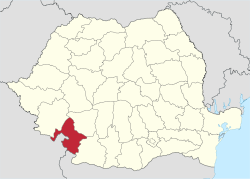
Mehedinți County
| Mehedinți County Județul Mehedinți | ||
|---|---|---|
| County | ||
| ||
 | ||
| Coordinates: 44°38′N 22°53′E / 44.63°N 22.88°ECoordinates: 44°38′N 22°53′E / 44.63°N 22.88°E | ||
| Country | Romania | |
| Development region | Sud-Vest | |
| Historical region | Oltenia, Banat | |
| Capital | Drobeta-Turnu Severin | |
| Area | ||
| • Total | 4,933 km2 (1,905 sq mi) | |
| Area rank | 30th | |
| Population (2011) | ||
| • Total | 254,570 | |
| • Rank | 39th | |
| • Density | 52/km2 (130/sq mi) | |
| Telephone code | (+40) 252 or (+40) 352[1] | |
| ISO 3166 code | RO-MH | |
| Website |
County Council Prefecture | |
Mehedinți (Romanian pronunciation: [meheˈdint͡sʲ]) is a county (județ) of Romania on the border with Serbia and Bulgaria. It is mostly located in the historical province of Oltenia, with one municipality (Orșova) and three communes (Dubova, Eșelnița and Svinița) located in the Banat. The county seat is Drobeta-Turnu Severin.
Demographics
In 2011, it had a population of 254,570 and the population density was 51.6/km².
| Year | County population[3] |
|---|---|
| 1948 | 304,788 |
| 1956 | |
| 1966 | |
| 1977 | |
| 1992 | |
| 2002 | |
| 2011 |
Geography

This county has a total area of 4,933 km².
In the North-West there are the Mehedinți Mountains with heights up to 1500 m, part of the Western end of the Southern Carpathians.
The heights decrease towards the East, passing through the hills to a high plain - the Western end of the Romanian Plain.
In the South the Danube flows, forming a wide valley, with channels and ponds. Another important river is the Motru River in the East side, an affluent of the Jiu River. Also, in the West side there is the Cerna River forming a passage between the Oltenia region and the Banat region.
Neighbours
- Bulgaria in the South - Vidin Province.
- Serbia in the West and South-West - Bor District.
- Caraș-Severin County in the North-West.
- Gorj County in the North-East.
- Dolj County in the South-East.
Economy
The energetic sector is highly developed in the county, on the Danube being two big hydro electrical power plants (Iron Gates I and Iron Gates II). Also in NE of Drobeta-Turnu Severin there is a heavy water complex (Romag Prod).
The predominant industries in the county are:
- Chemical industry.
- Food and beverages industry.
- Textile industry.
- Mechanical components industry.
- Railway and ship equipment industry.
- Wood and paper industry.
In the North, coal and copper are extracted.
The South is mainly agricultural, suited for growing cereals on large surfaces. Also vegetables are cultivated and there are important surfaces of wines and fruit orchards.
Tourism

The main touristical destinations are:
- The city of Drobeta-Turnu Severin - the ruins of Trajan's first bridge over the Danube
- The city of Orșova.
- The Mehedinți Mountains.
- The Danube's Iron Gates.
- Baia de Aramă Monastery
Politics
The Mehedinți County Council, elected at the 2016 local government elections, is made up of 31 counselors, with the following party composition:[4]
| Party | Seats | Current County Council | ||||||||||||||||||
|---|---|---|---|---|---|---|---|---|---|---|---|---|---|---|---|---|---|---|---|---|
| PSD-UNPR Electoral Alliance | 18 | |||||||||||||||||||
| National Liberal Party | 11 | |||||||||||||||||||
| Alliance of Liberals and Democrats | 2 | |||||||||||||||||||
Administrative divisions

Mehedinți County has 2 municipalities, 3 towns and 61 communes
- Municipalities
- Drobeta-Turnu Severin - capital city; population: 86,475 (as of 2011)
- Orșova
- Towns
- Communes
- Bâcleș
- Bala
- Bălăcița
- Balta
- Bâlvănești
- Braniștea
- Breznița-Motru
- Breznița-Ocol
- Broșteni
- Burila Mare
- Butoiești
- Căzănești
- Cireșu
- Corcova
- Corlățel
- Cujmir
- Dârvari
- Devesel
- Dubova
- Dumbrava
- Eșelnița
- Florești
- Gârla Mare
- Godeanu
- Gogoșu
- Greci
- Grozești
- Gruia
- Hinova
- Husnicioara
- Ilovăț
- Ilovița
- Isverna
- Izvoru Bârzii
- Jiana
- Livezile
- Malovăț
- Obârșia de Câmp
- Obârșia-Cloșani
- Oprișor
- Pădina Mare
- Pătulele
- Podeni
- Ponoarele
- Poroina Mare
- Pristol
- Prunișor
- Punghina
- Rogova
- Salcia
- Șișești
- Șimian
- Șovarna
- Stângăceaua
- Svinița
- Tâmna
- Vânători
- Vânjuleț
- Vlădaia
- Voloiac
- Vrata
References
| Wikimedia Commons has media related to Mehedinți County. |
- ↑ The number used depends on the numbering system employed by the phone companies on the market.
- ↑ National Institute of Statistics, "Populația după etnie" Archived August 16, 2009, at the Wayback Machine.
- ↑ National Institute of Statistics, "Populația la recensămintele din anii 1948, 1956, 1966, 1977, 1992 și 2002" Archived September 22, 2006, at the Wayback Machine.
- ↑ "Mandate de CJ pe judete si competitori" (in Romanian). Biroul Electoral Central. 10 June 2016. Retrieved 16 June 2016.