Meeme, Wisconsin
| Meeme, Wisconsin | |
|---|---|
| Town | |
 | |
 Location of Meeme, Wisconsin | |
| Coordinates: 43°56′12″N 87°51′14″W / 43.93667°N 87.85389°W | |
| Country | United States |
| State | Wisconsin |
| County | Manitowoc |
| Area | |
| • Total | 36.3 sq mi (94.0 km2) |
| • Land | 36.2 sq mi (93.7 km2) |
| • Water | 0.1 sq mi (0.3 km2) |
| Elevation[1] | 794 ft (242 m) |
| Population (2000) | |
| • Total | 1,538 |
| • Density | 42.5/sq mi (16.4/km2) |
| Time zone | Central (CST) (UTC-6) |
| • Summer (DST) | CDT (UTC-5) |
| Area code(s) | 920 |
| FIPS code | 55-50625[2] |
| GNIS feature ID | 1583686[1] |
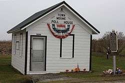
Meeme is a town in Manitowoc County, Wisconsin, United States. The population was 1,538 at the 2000 census. The unincorporated communities of Meeme, Osman, School Hill, and Spring Valley are located within the town.
Geography
According to the United States Census Bureau, the town has a total area of 36.3 square miles (94.0 km²), of which, 36.2 square miles (93.7 km²) of it is land and 0.1 square miles (0.3 km²) of it (0.28%) is water.
Demographics

As of the census[2] of 2000, there were 1,538 people, 531 households, and 432 families residing in the town. The population density was 42.5 people per square mile (16.4/km²). There were 558 housing units at an average density of 15.4 per square mile (6.0/km²). The racial makeup of the town was 98.70% White, 0.07% Native American, 0.33% Asian, 0.72% from other races, and 0.20% from two or more races. Hispanic or Latino of any race were 1.37% of the population.
There were 531 households out of which 37.9% had children under the age of 18 living with them, 72.3% were married couples living together, 5.6% had a female householder with no husband present, and 18.6% were non-families. 16.2% of all households were made up of individuals and 7.9% had someone living alone who was 65 years of age or older. The average household size was 2.90 and the average family size was 3.26.
In the town the population was spread out with 27.6% under the age of 18, 7.5% from 18 to 24, 28.5% from 25 to 44, 23.1% from 45 to 64, and 13.3% who were 65 years of age or older. The median age was 37 years. For every 100 females there were 104.5 males. For every 100 females age 18 and over, there were 104.2 males.
The median income for a household in the town was $55,139, and the median income for a family was $60,000. Males had a median income of $38,984 versus $26,200 for females. The per capita income for the town was $20,927. About 1.2% of families and 3.2% of the population were below the poverty line, including 3.8% of those under age 18 and 1.5% of those age 65 or over.
Notable people
- George Jonathan Danforth, politician
- John Lorfeld, politician
- Herman Roethel, politician
References
- 1 2 "US Board on Geographic Names". United States Geological Survey. 2007-10-25. Retrieved 2008-01-31.
- 1 2 "American FactFinder". United States Census Bureau. Archived from the original on September 11, 2013. Retrieved 2008-01-31.
Municipalities and communities of Manitowoc County, Wisconsin, United States | ||
|---|---|---|
| Cities | 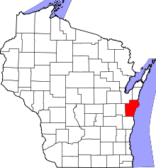 | |
| Villages | ||
| Towns | ||
| CDP | ||
| Unincorporated communities |
| |
| Footnotes | ‡This populated place also has portions in an adjacent county or counties | |
Coordinates: 43°55′14″N 87°49′53″W / 43.92056°N 87.83139°W