Medora, North Dakota
| Medora, North Dakota | |
|---|---|
| City | |
|
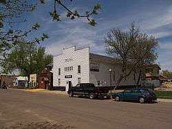
Business District of Medora (2008) | |
| Motto: "North Dakota's #1 Destination"[1] | |
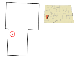 Location within Billings County and North Dakota | |
 Medora, North Dakota Location in the United States | |
| Coordinates: 46°54′51″N 103°31′30″W / 46.91417°N 103.52500°WCoordinates: 46°54′51″N 103°31′30″W / 46.91417°N 103.52500°W | |
| Country |
|
| State |
|
| County | Billings |
| Government | |
| • Mayor | Doug Ellison |
| Area[2] | |
| • Total | 0.37 sq mi (0.96 km2) |
| • Land | 0.36 sq mi (0.93 km2) |
| • Water | 0.01 sq mi (0.03 km2) |
| Elevation | 2,267 ft (691 m) |
| Population (2010)[3] | |
| • Total | 112 |
| • Estimate (2014)[4] | 132 |
| • Density | 311.1/sq mi (120.1/km2) |
| Time zone | Mountain (MST) (UTC-7) |
| • Summer (DST) | MDT (UTC-6) |
| ZIP code | 58645 |
| Area code(s) | 701 |
| FIPS code | 38-51900 |
| GNIS feature ID | 1035000[5] |
| Website | medorand.com |
Medora is a city in Billings County, North Dakota, United States. It is the county seat of, and only incorporated place in Billings County.[6] This city is home to Little Missouri National Grassland. The population was 112 at the 2010 census.[7] It is part of the Dickinson Micropolitan Statistical Area.
History
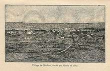
Medora was founded in 1883 along the transcontinental rail line of the Northern Pacific Railway by French nobleman Marquis de Mores, who named the city after his wife Medora von Hoffman.[8] Marquis de Mores wanted to ship refrigerated meat to Chicago via the railroad. He built a meat packing plant for this purpose and a house named the Chateau de Mores, which is now a museum.[9]
In the evening of April 7, 1903, President Theodore Roosevelt visited Medora on a presidential tour of the Western United States. Most of the Badlands' residents turned out to greet him on his whistle stop.[10] Roosevelt later recalled that “the entire population of the Badlands down to the smallest baby had gathered to meet me… They all felt I was their man, their old friend; and even if they had been hostile to me in the old days when we were divided by the sinister bickering and jealousies and hatreds of all frontier communities, they now firmly believed they had always been my staunch friends and admirers. I shook hands with them all and…I only regretted that I could not spend three hours with them."[11] A local hotel changed its name that same year to the Rough Riders Hotel. In 1986 the hotel was purchased and operated by the Theodore Roosevelt Medora Foundation.[12]
The city of Medora is also home to the popular Medora Musical and the city has become one of the most popular tourist attractions in the state.
Geography
Medora is located at 46°54′51″N 103°31′30″W / 46.91417°N 103.52500°W (46.914258, -103.524942).[13]
According to the United States Census Bureau, the city has a total area of 0.37 square miles (0.96 km2), of which, 0.36 square miles (0.93 km2) is land and 0.01 square miles (0.03 km2) is water.[2]
Climate
According to the Köppen Climate Classification system, Medora has a semi-arid climate, abbreviated "BSk" on climate maps.[14]
Demographics
| Historical population | |||
|---|---|---|---|
| Census | Pop. | %± | |
| 1960 | 133 | — | |
| 1970 | 129 | −3.0% | |
| 1980 | 94 | −27.1% | |
| 1990 | 101 | 7.4% | |
| 2000 | 100 | −1.0% | |
| 2010 | 112 | 12.0% | |
| Est. 2015 | 133 | [15] | 18.8% |
| U.S. Decennial Census[16] 2014 Estimate[4] | |||
2010 census
As of the census[3] of 2010, there were 112 people, 56 households, and 27 families residing in the city. The population density was 311.1 inhabitants per square mile (120.1/km2). There were 102 housing units at an average density of 283.3 per square mile (109.4/km2). The racial makeup of the city was 93.8% White, 1.8% Native American, 3.6% Asian, and 0.9% from two or more races.
There were 56 households of which 10.7% had children under the age of 18 living with them, 44.6% were married couples living together, 1.8% had a female householder with no husband present, 1.8% had a male householder with no wife present, and 51.8% were non-families. 46.4% of all households were made up of individuals and 16.1% had someone living alone who was 65 years of age or older. The average household size was 1.84 and the average family size was 2.63.
The median age in the city was 45.3 years. 11.6% of residents were under the age of 18; 10% were between the ages of 18 and 24; 27.8% were from 25 to 44; 32.1% were from 45 to 64; and 18.8% were 65 years of age or older. The gender makeup of the city was 47.3% male and 52.7% female.
2000 census
As of the census of 2000, there were 100 people, 51 households, and 23 families residing in the city. The population density was 271.7 people per square mile (104.4/km²). There were 117 housing units at an average density of 317.9 per square mile (122.1/km²). The racial makeup of the city was 100.00% White. Hispanic or Latino of any race were 1.00% of the population.
There were 51 households out of which 21.6% had children under the age of 18 living with them, 31.4% were married couples living together, 11.8% had a female householder with no husband present, and 54.9% were non-families. 51.0% of all households were made up of individuals and 11.8% had someone living alone who was 65 years of age or older. The average household size was 1.96 and the average family size was 3.00.
In the city the population was spread out with 26.0% under the age of 18, 4.0% from 18 to 24, 29.0% from 25 to 44, 26.0% from 45 to 64, and 15.0% who were 65 years of age or older. The median age was 41 years. For every 100 females there were 96.1 males. For every 100 females age 18 and over, there were 94.7 males.
The median income for a household in the city was $31,563, and the median income for a family was $61,250. Males had a median income of $26,042 versus $21,094 for females. The per capita income for the city was $23,399. There were no families and 4.8% of the population living below the poverty line, including no under eighteens and 15.0% of those over 64.
Points of interest
References
- ↑ "Medora, North Dakota". Medora, North Dakota. Retrieved August 14, 2012.
- 1 2 "US Gazetteer files 2010". United States Census Bureau. Archived from the original on January 24, 2012. Retrieved 2012-06-14.
- 1 2 "American FactFinder". United States Census Bureau. Retrieved 2012-06-14.
- 1 2 "Population Estimates". United States Census Bureau. Retrieved July 9, 2015.
- ↑ "US Board on Geographic Names". United States Geological Survey. 2007-10-25. Retrieved 2008-01-31.
- ↑ "Find a County". National Association of Counties. Archived from the original on May 31, 2011. Retrieved 2011-06-07.
- ↑ "2010 Census Redistricting Data (Public Law 94-171) Summary File". American FactFinder. United States Census Bureau. Archived from the original on July 21, 2011. Retrieved 2 May 2011.
- ↑ Wick, Douglas A. "Medora (Billings County)". North Dakota Place Names. Retrieved 8 May 2011.
- ↑ Chateau de Mores - State of North Dakota
- ↑ http://www.nps.gov/nr/travel/presidents/t_roosevelt_park.html
- ↑ http://www.mandanhistory.org/areahistory/1903trvisittondak.html
- ↑ http://reservations.medora.com/rough-riders/history/
- ↑ "US Gazetteer files: 2010, 2000, and 1990". United States Census Bureau. 2011-02-12. Retrieved 2011-04-23.
- ↑ Climate Summary for Medora, North Dakota
- ↑ "Annual Estimates of the Resident Population for Incorporated Places: April 1, 2010 to July 1, 2015". Retrieved July 2, 2016.
- ↑ United States Census Bureau. "Census of Population and Housing". Archived from the original on May 11, 2015. Retrieved September 7, 2013.
External links
Municipalities and communities of Billings County, North Dakota, United States | ||
|---|---|---|
| City | 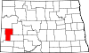 | |
| Unorganized territories | ||
| Unincorporated communities | ||