Mediterranean tropical-like cyclone
Mediterranean tropical-like cyclones, sometimes referred to as Mediterranean hurricanes or medicanes, are rare meteorological phenomena observed in the Mediterranean Sea. Due to the dry nature of the Mediterranean region, formation of tropical cyclones is infrequent, with only 99 recorded tropical-like storms between 1948 and 2011. No agency, however, is officially responsible for monitoring the formation and development of medicanes. Tropical cyclogenesis typically occurs within two separate regions of the sea. The first region, encompassing areas of the western Mediterranean, is more conducive for development than the other, the Ionian Sea to the east. The rough mountainous geography of the region raises additional difficulties despite being favorable for the development of severe weather and convective activity in general, and only with abnormal meteorological circumstances can medicanes form. Numerous studies have been conducted on the impact of global warming on Mediterranean tropical cyclone formation, generally concluding that fewer yet more intense storms would form.
The development of tropical cyclones in the Mediterranean Sea can usually only occur under somewhat unusual circumstances. Low wind shear and atmospheric instability induced by incursions of cold air are often required. A majority of medicanes are also accompanied by upper-level troughs, providing energy required for intensifying atmospheric convection—thunderstorms—and heavy precipitation. The baroclinic properties of the Mediterranean region, with high temperature gradients, also provides necessary instability for the formation of tropical cyclones. Another factor, rising cool air, provides necessary moisture as well. Warm sea surface temperatures (SSTs) are mostly unnecessary, however, as most medicanes' energy is derived from warmer air temperatures. When these favorable circumstances coincide, the genesis of warm-core Mediterranean tropical cyclones, often from within existing cut-off cold-core lows, is possible in a conducive environment for formation.
Several notable and damaging medicanes are known to have occurred. In September 1969, a north African Mediterranean tropical cyclone produced flooding that killed nearly 600 individuals, left 250,000 homeless, and crippled local economies. A medicane in September 1996 that developed in the Balearic Islands region spawned six tornadoes and inundated parts of the islands. Several medicanes have also been subject to extensive study, such as those of January 1982, January 1995, September 2006, November 2011, and November 2014. The January 1995 storm is one of the best-studied Mediterranean tropical cyclones, with its close resemblance to tropical cyclones elsewhere and availability of observations. The medicane of September 2006, meanwhile, is well-studied due to availability of existing observations and data. In November 2011, the NOAA's Satellite Analysis Branch monitored a possible medicane, named Rolf by the Free University of Berlin (FU Berlin), though it ceased doing so the following month. No agency is officially responsible for monitoring the basin.
Climatology
Mediterranean tropical cyclones are not considered to be formally classified tropical cyclones and their region of formation is not officially monitored by any agency,[1] and though the Satellite Analysis Branch released information related to a medicane in November 2011 while it was active, it ceased doing so on 16 December 2011.[2] The Mediterranean Sea, however, lies within the Greek area of responsibility,[3] while France's Météo-France National serves as a "preparation service" for the areas as well.[4] A majority of Mediterranean tropical cyclones form over two separate regions. The first, more conducive for development than the other, encompasses an area of the western Mediterranean bordered by the Balearic Islands, southern France, and the shorelines of the islands of Corsica and Sardinia. The second identified region of development, in the Ionian Sea between Sicily and Greece and stretching south to Libya, is less favorable for tropical cyclogenesis. An additional two regions, in the Aegean and Adriatic seas, produce fewer medicanes, while activity is minimal in the Levantine region. The geographical distribution of Mediterranean tropical cyclones is markedly different than that of other cyclones, with the formation of regular cyclones centering on the Pyrenees and Atlas mountain ranges, the Gulf of Genoa, and the island of Cyprus in the Ionian Sea.[5] Although meteorological factors are most advantageous in the Adriatic and Aegean seas, the closed nature of the region's geography, bordered by land, allows little time for further evolution.[6]
The geography of mountain ranges bordering the Mediterranean are conducive for severe weather and thunderstorms, with the sloped nature of mountainous regions permitting the development of convective activity.[7] Although the geography of the Mediterranean region, as well as its dry air, typically prevent the formation of tropical cyclones, when certain meteorological circumstances arise, difficulties influenced by the region's geography are overcome.[8] The occurrence of tropical cyclones in the Mediterranean Sea is generally extremely rare, with an average of 1.57 forming annually and merely 99 recorded occurrences of tropical-like storms discovered between 1948 and 2011 in a modern study, with no definitive trend in activity in that period.[9] Few medicanes form during the summer season, though activity typically rises in autumn, peaks in January, and gradually decreases from February to May.[5] In the western Mediterranean region of development, approximately 0.75 such systems form each year, compared to 0.32 in the Ionian Sea region.[10]
Studies have evaluated that global warming can result in higher observed intensities of tropical cyclones as a result of deviations in the surface energy flux and atmospheric composition, which both heavily influence the development of medicanes as well. In tropical and subtropical areas, sea surface temperatures (SSTs) rose 0.2 °C (0.36 °F) within a 50-year period, and in the North Atlantic and Western Pacific tropical cyclone basins, the potential destructiveness and energy of storms nearly doubled within the same duration, evidencing a clear correlation between global warming and tropical cyclone intensities.[11] Within a similarly recent 20-year period,[12] SSTs in the Mediterranean Sea increased by 0.6 to 1 °C (1.1 to 1.8 °F),[11] though no observable increase in medicane activity has been noted, as of yet.[9] In 2006, a computer-driven atmospheric model evaluated the future frequency of Mediterranean cyclones between 2071 and 2100, projecting a decrease in autumn, winter, and spring cyclonic activity coinciding with a dramatic increase in formation near Cyprus, with both scenarios attributed to elevated temperatures as a result of global warming.[13] Other studies, however, have been inconclusive, forecasting both increases and decreases in duration, number, and intensity.[14] Three independent studies, using different methodologies and data, evaluated that while medicane activity would likely decline with a rate depending on the climate scenario considered, a higher percentage of those that formed would be of greater strength.[15][16][17]
Development and characteristics
Factors required for the formation of medicanes are somewhat different than that normally expected of tropical cyclones; known to emerge over regions with sea surface temperatures (SSTs) below 26 °C (79 °F), Mediterranean tropical cyclones often require incursions of colder air to induce atmospheric instability.[5] A majority of medicanes develop above regions of the Mediterranean with SSTs of 15 to 26 °C (59 to 79 °F), with the upper bound only found in the southernmost reaches of the sea. Despite the low sea surface temperatures, the instability incited by cold atmospheric air within a baroclinic zone—regions with high differences in temperature and pressure—permits the formation of medicanes, in contrast to tropical areas lacking high baroclinity, where raised SSTs are needed.[18] While significant deviations in air temperature have been noted around the time of Mediterranean tropical cyclones' formation, few anomalies in sea surface temperature coincide with their development, indicating that the formation of medicanes is primarily controlled by higher air temperatures, not by anomalous SSTs.[19] Similar to tropical cyclones, minimal wind shear—difference in wind speed and direction over a region—as well as abundant moisture and vorticity encourages the genesis of tropical cyclone-like systems in the Mediterranean Sea.[20]
Due to the confined character of the Mediterranean and the limited capability of heat fluxes—in the case of medicanes, air—sea heat transfer—tropical cyclones with a diameter larger than 300 km (190 mi) cannot exist within the Mediterranean.[21] Despite being a relatively baroclinic area with high temperature gradients, the primary energy source utilized by Mediterranean tropical cyclones is derived from underlying heat sources generated by the presence of convection—thunderstorm activity—in a humid environment, similar to tropical cyclones elsewhere outside the Mediterranean Sea.[22] In comparison to other tropical cyclone basins, the Mediterranean Sea generally presents a difficult environment for development; although the potential energy necessary for development is not abnormally large, its atmosphere is characterized by its lack of moisture, impeding potential formation. The full development of a medicane often necessitates the formation of a large-scale baroclinic disturbance transitioning late in its life cycle into a tropical cyclone-like system, nearly always under the influence of a deep, cut-off, cold-core low within the middle-to-upper troposphere, frequently resulting from abnormalities in a wide-spreading Rossby wave—massive meanders of upper-atmospheric winds.[23]
The development of medicanes often results from the vertical shift of air in the troposphere as well, resulting in a decrease in its temperature coinciding with an increase in relative humidity, creating an environment more conducive for tropical cyclone formation. This, in turn, leads to in an increase in potential energy, producing heat-induced air-sea instability. Moist air prevents the occurrence of convective downdrafts—the vertically downward movement of air—which often hinder the inception of tropical cyclones,[23] and in such a scenario, wind shear remains minimal; overall, cold-core cut-off lows serve well for the later formation of compact surface flux-influenced warm-core lows such as medicanes. The regular genesis of cold-core upper-level lows and the infrequency of Mediterranean tropical cyclones, however, indicate that additional unusual circumstances are involved the emergence of the latter. Elevated sea surface temperatures, contrasting with cold atmospheric air, encourage atmospheric instability, especially within the troposphere.[18]
In general, most medicanes maintain a radius of 70 to 200 km (40 to 120 mi), last between 12 hours and 5 days, travel between 700 to 3,000 km (430 to 1,860 mi), develop an eye for less than 72 hours, and feature wind speeds of up to 144 km/h (89 mph);[24] in addition, a majority are characterized on satellite imagery as asymmetric systems with a distinct round eye encircled by atmospheric convection.[21] Weak rotation, similar to that in most tropical cyclones, is usually noted in a medicane's early stages, increasing with intensity;[25] medicanes, however, often have less time to intensify, remaining weaker than most North Atlantic hurricanes and only persisting for the duration of a few days.[26] The maximum achievable intensity of medicanes is equivalent to the lowest classification on the Saffir–Simpson hurricane wind scale, Category 1. While the entire lifetime of a cyclone may encompass several days, most will only retain tropical characteristics for less than 24 hours.[27] Circumstances sometimes permit the formation of smaller-scale medicanes, although the required conditions differ even from those needed by other medicanes. The development of abnormally small tropical cyclones in the Mediterranean usually requires upper-level atmospheric cyclones inducing cyclogenesis in the lower atmosphere, leading to the formation of warm-core lows, encouraged by favorable moisture, heat, and other environmental circumstances.[28]
Mediterranean cyclones have been compared to polar lows—cyclonic storms which typically develop in the far regions of the Northern and Southern Hemispheres—for their similarly small size and heat-related instability; however, while medicanes nearly always feature warm-core lows, polar lows are primarily cold-core. The prolonged life of medicanes and similarity to polar lows is caused primarily by origins as synoptic-scale surface lows and heat-related instability.[7] Heavy precipitation and convection within a developing Mediterranean tropical cyclone are usually incited by the approach of an upper-level trough—an elongated area of low air pressures—bringing downstream cold air, encircling an existing low-pressure system. After this occurs, however, a considerable reduction in rainfall rates occurs despite further organization,[29] coinciding with a decrease in previously high lightning activity as well.[30] Although troughs will often accompany medicanes along their track, separation eventually occurs, usually in the later part of a Mediterranean tropical cyclone's life cycle.[29] At the same time, moist air, saturated and cooled while rising into the atmosphere, then encounters the medicane and permits further development and evolution into a tropical cyclone. Many of these characteristics are also evident in polar lows.[31]
Notable occurrences and impacts
September 1969
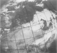
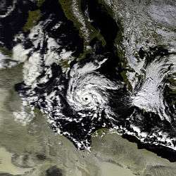
An unusually severe Mediterranean tropical cyclone developed on 23 September 1969 southeast of Malta, producing severe flooding.[32] Steep pressure and temperature gradients above the Atlas mountain range were evident on 19 September, a result of cool sea air attempting to penetrate inland; south of the mountains, a lee depression—a low-pressure area in a mountainous region—developed. Under the influence of mountainous terrain, the low initially meandered northeastward. Following the entry of cool sea air, however, it recurved to the southeast before transitioning into a Saharan depression associated with a distinct cold front by 22 September. Along the front's path, desert air moved northward while cold air drifted in the opposite direction, and in northern Libya, warm arid air clashed with the cooler levant of the Mediterranean. The organization of the disturbance improved slightly further before emerging into the Mediterranean Sea on 23 September, upon which the system experienced immediate cyclogenesis,[33] rapidly intensifying while southeast of Malta as a cold-core cut-off low,[34] and acquiring tropical characteristics.[32] In western Africa, meanwhile, several disturbances converged toward Mauritania and Algeria, while the medicane recurved southwestward back toward the coast, losing its closed circulation and later dissipating.[34]
The cyclone produced severe flooding throughout regions of northern Africa. Malta received upward of 123 mm (4.8 in) of rainfall on 23 September, Sfax measured 45 mm (1.8 in) on 24 September, Tizi Ouzou collected 55 mm (2.2 in) on 25 September, Gafsa received 79 mm (3.1 in) and Istanbul measured 46 mm (1.8 in) on 26 September, Cap Bengut collected 43 mm (1.7 in) on 27 September, and Biskra received 122 mm (4.8 in) on 28 September.[35] In Malta, a 20000-ton tanker struck a reef and split in two, while in Gafsa, Tunisia, the cyclone flooded phosphate mines, leaving over 25,000 miners unemployed and costing the government over £2 million per week. Thousands of camels and snakes, drowned by flood waters, were swept out to sea, and massive Roman bridges, which withstood all floods since the fall of the Roman Empire, collapsed. In all, the floods in Tunisia and Algeria killed almost 600 individuals, left 250,000 homeless, and severely damaged regional economies.[36] Due to communication problems, however, flood relief funds and television appeals were not set up until nearly a month later.[35]
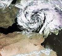
January 1982
The unusual Mediterranean tropical storm of January 1982 was first detected in waters north of Libya.[32] The storm likely reached the Atlas mountain range as a low-pressure area by 23 January 1982, reinforced by an elongated, slowly-drifting trough above the Iberian Peninsula. Eventually, a closed circulation center developed by 1310 UTC,[37] over parts of the Mediterranean with sea surface temperatures (SSTs) of approximately 16 °C (61 °F) and air temperature of 12 °C (54 °F).[38] A hook-shaped cloud developed within the system shortly thereafter, rotating as it elongated into a 150 km (93 mi)-long comma-shaped apparatus. After looping around Sicily, it drifted eastward between the island and Peloponnese, recurving on its track again,[39] exhibiting clearly curved spiral banding before shrinking slightly.[40] The cyclone reached its peak intensity at 1800 UTC on the following day, maintaining an atmospheric pressure of 992 mbar (29.30 inHg), and was succeeded by a period of gradual weakening, with the system's pressure eventually rising to 1009 mbar (29.80 inHg). The system slightly reintensified, however, for a six-hour period on 26 January. Ship reports indicated winds of 93 km/h (57,7 mph or 50,2 kt) were present in the cyclone at the time, tropical storm-force winds on the Saffir–Simpson hurricane wind scale,[37] likely near the eyewall of the cyclone, which features the highest winds in a tropical cyclone.[38] However, Without corroborative reports, it is difficult to assess how well the ship’s reported wind speed of 50 knots conformed to the actual maximum sustained wind associated with this system. Vmax estimated equals 31.5 m/s (61.2 knots), or least eleven knots higher than the ship’s observation.[41]
The Global Weather Center's Cyclone Weather Center of the United States Air Force (USAF) initiated "Mediterranean Cyclone Advisories" on the cyclone at six-hour intervals starting at 1800 UTC on 27 January until 0600 UTC the following day.[41] Convection was most intense in the eastern sector of the cyclone as it drifted east-northeastward. On infrared satellite imagery, the eye itself was 58.5 km (36.4 mi) in diameter,[38] contracting to just 28 kilometres (17 mi) one day prior to making landfall.[41] The cyclone passed by Malta, Italy, and Greece before dissipating several days later in the extreme eastern Mediterranean. Observations related to the cyclone, however, were inadequate, and although the system maintained numerous tropical characteristics, it is possible it was merely a compact but powerful extratropical cyclone exhibiting a clear eye, spiral banding, towering cumulonimbi, and high surface winds along the eyewall.[32] The warm sea surface and intense convection most likely produced a small warm core. Could this Mediterranean cyclone have been an unnamed Tropical cyclone? Examination of the available data, both conventional and satellite, suggests that very real possibility.[41]
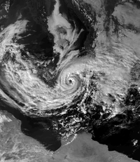
January 1995
Among numerous documented medicanes, the cyclone of January 1995 is generally considered to be the best-documented instance. Emerging off of the Libyan coast into the central Mediterranean Sea toward the Ionian shoreline of Greece on 13 January as a compact low-pressure area, the precursor low maintained winds reaching up to 108 km/h (67 mph) as it traversed the Ionian Sea,[42] while the German research ship Meteor noted winds of 135 km/h (84 mph).[43] Upon the low's approach near Greece, it began to envelop an area of atmospheric convection; meanwhile, in the middle troposphere, a trough extended from Russia to the Mediterranean, bringing with it extremely cold temperatures.[44] Two low-pressure areas were present along the path of the trough, with one situated above Ukraine and the other above the central Mediterranean, likely associated with a low-level cyclone over western Greece. Upon weakening and dissipation on 14 January, a second low, the system which would evolve into the Mediterranean tropical cyclone, developed in its place on 15 January.[43]
At the time of formation, high clouds indicated the presence of intense convection,[43] and the cyclone featured an axisymmetric cloud structure, with a distinct, cloud-free eye and rainbands spiraling around the disturbance as a whole.[45] Soon thereafter, the parent low separated from the medicane entirely and continued eastward,[44] meandering toward the Aegean Sea and Turkey.[42] Initially remaining stationary between Greece and Sicily with a minimum atmospheric pressure of 1002 mbar (29.59 inHg), the newly formed system began to drift southwest-to-south in the following days, influenced by northeasterly flow incited by the initial low, now far to the east, and a high-pressure area above central and eastern Europe.[44] The system's atmospheric pressure increased throughout 15 January due to the fact it was embedded within a large-scale environment, with its rising pressure due to the general prevalence of higher air pressures throughout the region, and was not a sign of deintensification.[45]
Initial wind speeds within the young medicane were generally low, with sustained winds of merely 28 to 46 km/h (17 to 29 mph), with the highest recorded value associated with the disturbance being 63 km/h (39 mph) at 0000 UTC on 16 January, slightly below the threshold for tropical storm on the Saffir–Simpson hurricane wind scale. Its structure now consisted of a distinct eye encircled by counterclockwise-rotating cumulonimbi with cloud top temperatures still colder than −50 °C (−58 °F), evidencing deep convection and a regular feature observed in most tropical cyclones.[46] At 1200 UTC on 16 January, a ship (9VYT) provided an observation from about 50 km north-northeast of the cyclone centre of winds blowing approximately east/southeast at 50 knots (25.75 m/s) (Blier & Ma, 1997).[47] However (like 1982 system), Without corroborative reports, it is difficult to assess how well the ship’s reported wind speed of 50 knots conformed to the actual maximum sustained wind associated with this system.[41] Intense convection continued to follow the entire path of the system as it traversed the Mediterranean, and the cyclone made landfall in northern Libya at approximately 1800 UTC on 17 January, rapidly weakening after coming ashore.[44] As it moved inland, a minimum atmospheric pressure of 1012 mbar (29.89 inHg) was recorded, accompanied by wind speeds of 93 km/h (58 mph) as it slowed down after passing through the Gulf of Sidra.[47] Although the system retained its strong convection for several more hours, the cyclone's cloud tops began to warm, evidencing lower clouds, before losing tropical characteristics entirely on 17 January.[48] Offshore ship reports recorded that the medicane produced intense winds, copious rainfall, and abnormally warm temperatures.[49]
September and October 1996

Three notable medicanes developed in 1996. The first, in mid-September 1996, was a typical Mediterranean tropical cyclone that developed in the Balearic Islands region.[50] At the time of the cyclone's formation, a powerful Atlantic cold front and a warm front associated with a large-scale low, producing northeasterly winds over the Iberian peninsula, extended eastward into the Mediterranean, while abundant moisture gathered in the lower troposphere over the Balearic channel.[51] On the morning of 12 September, a disturbance developed off of Valencia, Spain, dropping heavy rainfall on the coast even without coming ashore. An eye developed shortly thereafter as the system rapidly traversed across Majorca and Sardinia in its eastward trek. It made landfall upon the coast of southern Italy on the evening of 13 September with a minimum atmospheric pressure of 990 mbar (29.24 inHg), dissipating shortly after coming ashore,[52] with a diameter of about 150 km (93 mi).[28]
At Valencia and other regions of eastern Spain, the storm generated heavy precipitation, while six tornadoes touched down over the Balearic Islands. While approaching the coast of the Balearic Islands, the warm-core low induced a pressure drop of 11 mbar (0.32 inHg) at Palma, Majorca in advance of the tropical cyclone's landfall. Medicanes as small as the one that formed in September 1996 are atypical, and often require circumstances different even from those required for regular Mediterranean tropical cyclone formation.[28] Warm low-level advection–transfer of heat through air or sea–caused by a large-scale low over the western Mediterranean was a primary factor in the rise of strong convection.[7] The presence of a mid- to upper-level cut-off cold-core low, a method of formation typical to medicanes, was also key to the development of intense thunderstorms within the cyclone. In addition, interaction between a northeastward-drifting trough, the medicane, and the large-scale also permitted the formation of tornadoes within thunderstorms generated by the cyclone after making landfall.[53]
The second of the three recorded Mediterranean tropical cyclones in 1996 formed between Sicily and Tunisia on 4 October, making landfall on both Sicily and southern Italy. The medicane generated major flooding in Sicily; meanwhile, in Calabria, wind gusts of up to 108 km/h (67 mph) were reported in addition to severe inundation.[32] The third major Mediterranean tropical cyclone of that year formed north of Algeria and strengthened while sweeping between the Balearic Islands and Sardinia, with an eye-like feature prominent on satellite. The eye was distorted and disappeared after transiting over southern Sardinia throughout the evening of 8 October, with the system weakening as a whole. On the morning of October 9, a smaller eye emerged as the system passed over the Tyrrhenian Sea, gradually strengthening, with reports 100 km (62 mi) from the storm's center reporting winds of 90 km/h (56 mph). Extreme damage was reported in the Aeolian Islands after the tropical cyclone passed north of Sicily, though the system dissipated while turning southward over Calabria. Overall, the lowest estimated atmospheric pressure in the third medicane was 998 mbar (29.47 inHg).[54] Both October systems featured distinctive spiral bands, intense convection, high sustained winds, and abundant precipitation.[32]
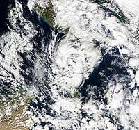
September 2006

A short-lived medicane developed near the end of September 2006 along the coast of Italy. The origins of the medicane can be traced to the alpine Atlas mountain range on the evening of 25 September,[50] likely forming as a normal lee cyclone.[55] At 0600 UTC on 26 September, European Centre for Medium-Range Weather Forecasts (ECMWF) model analyses indicated the existence of two low-pressure areas along the shoreline of Italy, one on the west coast, sweeping eastward across the Tyrrhenian Sea, while the other, slightly more intense, low was located over the Ionian Sea.[56] As the latter low approached the Strait of Sicily, it met an eastward-moving convection-producing cold front, resulting in significant intensification, while the system simultaneously reduced in size.[55] It then achieved a minimum atmospheric pressure of approximately 986 mbar (29.12 inHg) after transiting north-northeastward across the 40 km (25 mi)-wide Salentine peninsula in the course of roughly 30 minutes at 0915 UTC the same day.[56]
Wind gusts surpassing 144 km/h (89 mph) were recorded as it passed over Salento due to a steep pressure gradient associated with it, confirmed by regional radar observations denoting the presence of a clear eye.[56] The high winds inflicted moderate damages throughout the peninsula, though specific damage is unknown.[50] Around 1000 UTC,[56] both radar and satellite recorded the system's entry into the Adriatic Sea and its gradual northwestward curve back toward the Italian coast. By 1700 UTC, the cyclone made landfall in northern Apulia while maintaining its intensity, with a minimum atmospheric pressure at 988 mbar (29.18 inHg). The cyclone weakened while drifting further inland over the Italian mainland, eventually dissipating as it curved west-southwestward. A later study in 2008 evaluated that the cyclone possessed numerous characteristics seen in tropical cyclones elsewhere, with a spiral appearance, eye-like apparatus, rapid atmospheric pressure decreases in advance of landfall, and intense sustained winds, concentrated near the storm's eyewall;[57] the apparent eye-like structure in the cyclone, however, was ill-defined.[49] Since then, the medicane has been the subject of significant study as a result of the availability of scientific observations and reports related to the cyclone.[56] In particular, the sensitivity of this cyclone to the sea surface temperature,[58] to the initial conditions and to the model,[59] to the parameterization schemes used in the simulations [60] were analyzed. Also, the relevance of different instability indices for the diagnosis and the prediction of these events were studied.[61]
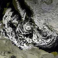
November 2011 (Rolf/01M)

In November 2011, the first officially designated Mediterranean tropical cyclone by the National Oceanic and Atmospheric Administration (NOAA) formed, christened as 01M by the Satellite Analysis Branch and given the name Rolf by the Free University of Berlin (FU Berlin),[2][62] despite the fact that no agency is officially responsible for monitoring tropical cyclone activity in the Mediterranean.[1] On 4 November 2011, a frontal system associated with another low-pressure area monitored by FU Berlin, designated Quinn, spawned a second low-pressure system inland near Marseille, which was subsequently named Rolf by the university. An upper-level trough on the European mainland stalled as it approached the Pyrenees before approaching and interacting with the low known as Rolf. Heavy rainfall consequently fell over regions of southern France and northwestern Italy, resulting in widespread landslides and flooding. On 5 November, Rolf slowed while stationed above the Massif Central, maintaining a pressure of 1000 mbar (29.53 inHg). A stationary front, stationed between Madrid and Lisbon, approached Rolf the same day, with the cold front later encountering and become associated with Rolf, which would continue for several days.[62]
On 6 November, the cyclone drifted toward the Mediterranean from the southern shoreline of France, shrinking to a diameter of merely 150 km (93 mi) across. Slightly weakening, Rolf neared the Balearic Islands on 7 November, associated with two fronts producing heavy rain throughout Europe, before separating entirely and transitioning into a cut-off low.[62] The same day, the NOAA began monitoring the system, designating it as 01M, marking the first time it officially monitored a medicane. A distinct eye-like feature developed while spiral banding and intense convection became evident. At its highest, the Dvorak technique classified the system as T3.0. Convection gradually decreased, and a misalignment of the mid- and upper- level centers was noted. The system continued to rapidly weaken on 9 November, before advisories were halted on the system later that day,[2] and FU Berlin followed suit by 11 November, removing the name Rolf from its weather maps and declaring its dissipation.[62] The deep warm core of this cyclone persisted for a longer time compared to other tropical-like cyclones in the Mediterranean.[30]
November 2014 (Qendresa)
| |||
| Duration | 6 November 2014 – 9 November 2014 | ||
|---|---|---|---|
| Peak intensity | 978 hPa (mbar) | ||


On 6 November 2014, the low-level circulation centre of Qendresa formed near Kerkennah Islands.[63] As the system was moving north-northeastwards and combining with an upper-level low from Tunisia early on 7 November, the system occluded quickly and intensified dramatically with an eye-like feature, thanks to favourable conditions. Qendresa directly hit Malta when it had lost its fronts with a more well-defined eye, with ten-minute sustained winds at 110.9 km/h (68.9 mph) and the gust at 153.7 km/h (95.5 mph).[64] The central pressure was presumed to be 978 hPa (28.88 inHg). Interacting with Sicily, the cyclone turned northeastwards and started to make an anticlockwise loop. On 8 November, Qendresa crossed Syracuse in the morning and then significantly weakened.[63] Turning southeastwards then moving eastwards, Qendresa dissipated as a remnant low west of Crete on 9 November.[65]
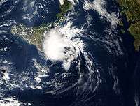
October 2016 (90M)

On early 28 October 2016, 35 mph (60 km/h) winds began to form into an extratropical cyclone south of Calabria, in the Ionian sea. It quickly intensified, attaining wind speeds of 50 mph (80 km/h) as it slowly moved to the west, causing high waves and minor damage to cars near the Maltese city of Valletta,[66] weakening the following day and beginning to move eastwards. However, later that day it began to re-intensify, becoming a tropical cyclone on 31 October. After passing over Crete it then began to quickly weaken, the remnants dissipating on 1 November.[67]
Other storms
Numerous other Mediterranean cyclones have occurred, but few have been as well-documented as those in 1969, 1982, 1995, 1996, 2006, 2011, and 2014. On 27 September 1983, a medicane was observed at sea between Tunisia and Sicily, looping around Sardinia and Corsica, coming ashore twice on the islands, before making landfall at Tunis early on 2 October and dissipating. The development of the system was not encouraged by baroclinic instability; rather, convection was incited by abnormally high sea surface temperatures (SSTs) at the time of its formation. It also featured a definitive eye, tall cumulonimbus clouds, intense sustained winds, and a warm core. For most of its duration, it maintained a diameter of 200 to 300 km (120 to 190 mi), though it shrank just before landfall on Ajaccio to a diameter of 100 km (62 mi). Four other notable cyclones occurred in the late twentieth century, on 26 March 1983, 29–30 December 1984, 30–31 October 1997, and 5–8 December 1997, all exhibiting characteristics closely resembling tropical cyclones elsewhere.[32]
A study performed in 2013 revealed several additional storms and additional information on medicanes forming on 7 April 1984, 14 December 1985, 5 December 1991, 15 January 1995, 10 December 1996, 26 January 1998, 19 March 1999, and 27 May 2003.[68] A second study, conducted in 2007, revealed additional storms forming on 18 October 2003, 27 October 2005, and 15 December 2005.[69] A third study revealed several other cyclones, of which developed on 13 September 1999, 10 September 2000, 9 October 2000, 19 September 2004, 3 November 2004, 17 and 26 October 2007, 4 December 2008, and 13 April 2012.[27]
See also
- Tropical cyclone effects in Europe
- South Atlantic tropical cyclone
- 1996 Lake Huron cyclone
- 2006 Central Pacific cyclone
- Tropical cyclone basins
- Tropical cyclogenesis
Notes
Citations
- 1 2 "TCFAQ F1) What regions around the globe have tropical cyclones and who". National Oceanic and Atmospheric Administration. Hurricane Research Division, Atlantic Oceanographic and Meteorological Laboratory. Retrieved 24 February 2014.
- 1 2 3 "2011 Tropical Bulletin Archive". National Oceanic and Atmospheric Administration. National Environmental Satellite, Data, and Information Service. 30 December 2011. Retrieved 23 February 2014.
- ↑ "OMM-JCOMM-GMDSS / World Marine Weather Forecast". Global Maritime Distress and Safety System. Météo-France. Retrieved 24 February 2014.
- ↑ "OMM-JCOMM-GMDSS / World Marine Weather Forecast". Global Maritime Distress and Safety System. Météo-France. Retrieved 24 February 2014.
- 1 2 3 Cavicchia et al. 2013, p. 7
- ↑ Cavicchia et al. 2013, p. 18
- 1 2 3 Homar et al. 2003, p. 1470
- ↑ Emanuel 2005, p. 220
- 1 2 Cavicchia et al. 2013, p. 6
- ↑ Cavicchia et al. 2013, p. 8
- 1 2 Tous & Romero 2013, p. 9
- ↑ Tous & Romero 2013, p. 10
- ↑ Anagnostopoulou et al. 2006, p. 13
- ↑ Gaertner et al. 2007, p. 4
- ↑ Cavicchia et al 2014, p. 7493
- ↑ Romero & Emanuel 2013, p. 6000
- ↑ Walsh et al 2014, p. 1059
- 1 2 Tous & Romero 2013, p. 8
- ↑ Cavicchia et al. 2013, p. 14
- ↑ Cavicchia et al. 2013, p. 15
- 1 2 Tous & Romero 2013, p. 3
- ↑ Tous & Romero 2013, p. 5
- 1 2 Tous & Romero 2013, p. 6
- ↑ Cavicchia & von Storch 2012, p. 2276
- ↑ Fita et al. 2007, p. 43
- ↑ Fita et al. 2007, p. 53
- 1 2 Miglietta et al. 2013, p. 2402
- 1 2 3 Homar et al. 2003, p. 1469
- 1 2 Claud et al. 2010, p. 2211
- 1 2 Miglietta et al. 2013, p. 2404
- ↑ Emanuel 2005, p. 217
- 1 2 3 4 5 6 7 Pytharoulis et al. 2000, p. 262
- ↑ Winstanley 1970, p. 393
- 1 2 Winstanley 1970, p. 396
- 1 2 Winstanley 1970, p. 392
- ↑ Winstanley 1970, p. 390
- 1 2 Ernst & Matson 1983, p. 333
- 1 2 3 Ernst & Matson 1983, p. 334
- ↑ Reed et al. 2001, p. 187
- ↑ Reed et al. 2001, p. 189
- 1 2 3 4 5 Ernst & Matson 1983, p. 337
- 1 2 Cavicchia & von Storch 2012, p. 2280
- 1 2 3 Pytharoulis et al. 2000, p. 263
- 1 2 3 4 Pytharoulis et al. 1999, p. 628
- 1 2 Pytharoulis et al. 2000, p. 264
- ↑ Pytharoulis et al. 2000, p. 265
- 1 2 Pytharoulis et al. 2000, p. 266
- ↑ Pytharoulis et al. 2000, p. 267
- 1 2 Cavicchia & von Storch 2012, p. 2281
- 1 2 3 Cavicchia & von Storch 2012, p. 2282
- ↑ Homar et al. 2003, p. 1473
- ↑ Cavicchia & von Storch 2012, p. 2283
- ↑ Homar et al. 2003, p. 1471
- ↑ Cavicchia & von Storch 2012, p. 2284
- 1 2 Claud et al. 2010, p. 2203
- 1 2 3 4 5 Moscatello et al. 2008, p. 4374
- ↑ Moscatello et al. 2008, p. 4375
- ↑ Miglietta et al., 2011
- ↑ Davolio et al., 2009
- ↑ Miglietta et al., 2015
- ↑ Conte et al., 2010
- 1 2 3 4 Ilmer, P. (12 August 2011). "Lebensgeschichte: Tiefdruckgebiet Rolf". Freie Universität Berlin (in German). Institut für Meteorologie. Retrieved 23 February 2014.
- 1 2 Sachweh, Michael (7 January 2015). "Qendresa - ein bemerkenswerter Medicane" (PDF) (in German). Munich: Free University of Berlin. Retrieved 1 November 2016.
- ↑ "A Medicane (MEDIterranean hurriCANE) or Tropical-Like Cyclone (TLC) brought severe weather to parts of the Mediterranean in early November.". EUMETSAT. 8 November 2014. Retrieved 5 November 2016.
- ↑ "Weather Chart" (GIF) (in German). Free University of Berlin. 9 November 2014. Retrieved 4 November 2016.
- ↑ "Watch: Strong Wave Batter Valletta Shoreline". timesofmalta.com. 28 October 2016. Retrieved 30 October 2016.
- ↑ Erdman, John (31 October 2016). "Halloween Surprise: Rare Tropical Storm Forms in Mediterranean Sea". Retrieved 3 November 2016.
- ↑ Tous & Romero 2013, p. 4
- ↑ Fita et al. 2007, p. 45
References
- Anagnostopoulou, C.; Tolika, K.; Flocas, H.; Maheras, P. (January 2006). "Cyclones in the Mediterranean region: present and future climate scenarios derived from a general circulation model (HadAM3P)" (PDF). Advances in Geosciences. European Geosciences Union. 7: 9–14. doi:10.5194/adgeo-7-9-2006.
- Cavicchia, L.; von Storch, H. (November 2012). "The simulation of medicanes in a high-resolution regional climate model" (PDF). Climate Dynamics. Springer Science+Business Media. 39 (9–10): 2273–2290. Bibcode:2012ClDy...39.2273C. doi:10.1007/s00382-011-1220-0.
- Cavicchia, L.; von Storch, H.; Gualdi, S. (September 2014). "A long-term climatology of medicanes" (PDF). Climate Dynamics. Springer Science+Business Media. 43 (5–6): 1183–1195. Bibcode:2014ClDy...43.1183C. doi:10.1007/s00382-013-1893-7.
- Cavicchia, L.; von Storch, H.; Gualdi, S. (October 2014). "A Mediterranean tropical-like cyclones in present and future climate". Journal of Climate. American Meteorological Society. 27 (19): 7493–7501. Bibcode:2014JCli...27.7493C. doi:10.1175/JCLI-D-14-00339.1.
- Claud, C.; Alhammoud, B.; Funatsu, B.M.; Chaboureau, J.-P. (October 2010). "Mediterranean hurricanes: large-scale environment and convective and precipitating areas from satellite microwave observations" (PDF). Natural Hazards and Earth System Sciences. European Geosciences Union. 10 (10): 2199–2213. Bibcode:2010NHESS..10.2199C. doi:10.5194/nhess-10-2199-2010.
- Conte, D.; Miglietta, M.M.; Levizzani, V. (July 2011). "IAnalysis of instability indices during the development of a Mediterranean tropical-like cyclone using MSG-SEVIRI products and the LAPS model". Atmospheric Research. Elsevier. 101 (1-2): 264–279. Bibcode:2011AtmRe.101..264C. doi:10.1016/j.atmosres.2011.02.016.
- Davolio, S.; Miglietta, M.M.; Moscatello, A.; Pacifico, A.; Buzzi, A.; Rotunno, R. (April 2009). "Numerical forecast and analysis of a tropical-like cyclone in the Ionian Sea" (PDF). Natural Hazards and Earth System Sciences. European Geosciences Union. 9 (2): 551–562. doi:10.5194/nhess-9-551-2009.
- Emanuel, K. (June 2005). "Genesis and maintenance of 'Mediterranean hurricanes'" (PDF). Advances in Geosciences. European Geosciences Union. 2: 217–220. doi:10.5194/adgeo-2-217-2005.
- Ernst, J.A.; Matson, M. (November 1983). "A Mediterranean tropical storm?". Weather. Royal Meteorological Society. 38 (11): 332–337. Bibcode:1983Wthr...38..332E. doi:10.1002/j.1477-8696.1983.tb04818.x.
- Fita, L.; Romero, R.; Luque, A.; Emanuel, K.; Ramis, C. (January 2007). "Analysis of the environments of seven Mediterranean tropical-like storms using an axisymmetric, nonhydrostatic, cloud resolving model" (PDF). Natural Hazards and Earth System Sciences. European Geosciences Union. 7 (1): 41–56. doi:10.5194/nhess-7-41-2007.
- Gaertner, M.A.; Jacob, D.; Gil, V.; Domínguez, M.; Padorno, E.; Sánchez, E.; Castro, M. (July 2007). "Tropical cyclones over the Mediterranean Sea in climate change simulations". Geophysical Research Letters. American Geophysical Union. 34 (14): L14711. Bibcode:2007GeoRL..3414711G. doi:10.1029/2007GL029977.
- Homar, V.; Romero, R.; Stensrud, D.J.; Ramis, C.; Alonso, S. (April 2003). "Numerical diagnosis of a small, quasi-tropical cyclone over the western Mediterranean: Dynamical vs. boundary factors". Quarterly Journal of the Royal Meteorological Society. Royal Meteorological Society. 129 (590): 1469–1490. Bibcode:2003QJRMS.129.1469H. doi:10.1256/qj.01.91.
- Miglietta, M.M.; Moscatello, A.; Conte, D.; Mannarini, G.; Lacorata, G.; Rotunno, R. (July 2011). "Numerical analysis of a Mediterranean 'hurricane' over south-eastern Italy: Sensitivity experiments to sea surface temperature". Atmospheric Research. Elsevier. 101 (1-2): 412–426. Bibcode:2011AtmRe.101..412M. doi:10.1016/j.atmosres.2011.04.006.
- Miglietta, M.M.; Mastrangelo, D.; Conte, D. (February 2015). "Influence of physics parameterization schemes on the simulation of a tropical-like cyclone in the Mediterranean Sea". Atmospheric Research. Elsevier. 153 (1): 360–375. Bibcode:2015AtmRe.153..360M. doi:10.1016/j.atmosres.2014.09.008.
- Miglietta, M.M.; Laviola, S.; Malvaldi, A.; Conte, D.; Levizzani, V.; Price, C. (May 2013). "Analysis of tropical-like cyclones over the Mediterranean Sea through a combined modeling and satellite approach". Geophysical Research Letters. American Geophysical Union. 40 (10): 2400–2405. Bibcode:2013GeoRL..40.2400M. doi:10.1002/grl.50432.
- Moscatello, A.; Miglietta, M.M.; Rotunno, R. (October 2008). "Observational analysis of a Mediterranean 'hurricane' over southeastern Italy" (PDF). Weather. Royal Meteorological Society. 63 (10): 306–311. Bibcode:2008Wthr...63..306M. doi:10.1002/wea.231.
- Moscatello, A.; Miglietta, M.M.; Rotunno, R. (November 2008). "Numerical analysis of a Mediterranean 'hurricane' over southeastern Italy" (PDF). Monthly Weather Review. American Meteorological Society. 136 (11): 4373–4397. Bibcode:2008MWRv..136.4373M. doi:10.1175/2008MWR2512.1.
- Pytharoulis, I.; Craig, G.C.; Ballard, S.P. (June 1999). "Study of a hurricane-like Mediterranean cyclone of January 1995". Physics and Chemistry of the Earth. Elsevier B.V. 24 (6): 627–632. Bibcode:1999PCEB...24..627P. doi:10.1016/S1464-1909(99)00056-8.
- Pytharoulis, I.; Craig, G.C.; Ballard, S.P. (September 2000). "The hurricane-like Mediterranean cyclone of January 1995". Meteorological Applications. Royal Meteorological Society. 7 (3): 261–279. Bibcode:2000MeApp...7..261P. doi:10.1017/S1350482700001511.
- Reed, R.J.; Kuo, Y.-H.; Albright, M.D.; Gao, K.; Guo, Y.-R.; Huang, W. (April 2001). "Analysis and modeling of a tropical-like cyclone in the Mediterranean Sea". Meteorology and Atmospheric Physics. Springer Science+Business Media. 76 (3–4): 183–202. Bibcode:2001MAP....76..183R. doi:10.1007/s007030170029.
- Romero, R.; Emanuel, K. (June 2013). "Medicane risk in a changing climate" (PDF). Journal of Geophysical Research: Atmospheres. American Geophysical Union. 118 (12): 5992–6001. Bibcode:2013JGRD..118.5992R. doi:10.1002/jgrd.50475.
- Tous, M.; Romero, R. (January 2013). "Meteorological environments associated with medicane development". International Journal of Climatology. Royal Meteorological Society. 33 (1): 1–14. doi:10.1002/joc.3428.
- Walsh, K.; Giorgi, F.; Coppola, E. (September 2014). "Mediterranean warm-core cyclones in a warmer world". Climate Dynamics. Springer Science+Business Media. 42 (3–4): 1053–1066. Bibcode:2014ClDy...42.1053W. doi:10.1007/s00382-013-1723-y.
- Winstanley, D. (September 1970). "The North African flood disaster, September 1969". Weather. Royal Meteorological Society. 25 (9): 390–403. Bibcode:1970Wthr...25..390W. doi:10.1002/j.1477-8696.1970.tb04128.x.