Medical Lake, Washington
| Medical Lake, Washington | |
|---|---|
| City | |
 Location of Medical Lake, Washington | |
| Coordinates: 47°34′17″N 117°41′00″W / 47.57139°N 117.68333°W | |
| Country | United States |
| State | Washington |
| County | Spokane |
| Area[1] | |
| • Total | 3.64 sq mi (9.43 km2) |
| • Land | 3.40 sq mi (8.81 km2) |
| • Water | 0.24 sq mi (0.62 km2) |
| Elevation | 2,425 ft (739 m) |
| Population (2010)[2] | |
| • Total | 5,060 |
| • Estimate (2015)[3] | 4,942 |
| • Density | 1,488.2/sq mi (574.6/km2) |
| Time zone | Pacific (PST) (UTC-8) |
| • Summer (DST) | PDT (UTC-7) |
| ZIP code | 99022 |
| Area code | 509 |
| FIPS code | 53-44690 |
| GNIS feature ID | 1512452[4] |
| Website | www.medical-lake.org |
Medical Lake is a city in Spokane County, Washington, United States. The population was 5,060 at the 2010 census. It is home to a psychiatric hospital, Eastern State Hospital.
History
Medical Lake was officially incorporated on June 21, 1880. It took its name from a nearby lake Native Americans believed held medicinal qualities.[5]
Geography
Medical Lake is located at 47°34′17″N 117°41′00″W / 47.571384°N 117.683333°WCoordinates: 47°34′17″N 117°41′00″W / 47.571384°N 117.683333°W (47.571384, -117.683333).[6]
According to the United States Census Bureau, the city has a total area of 3.64 square miles (9.43 km2), of which, 3.40 square miles (8.81 km2) is land and 0.24 square miles (0.62 km2) is water.[1]
The city is named for an eponymous lake, and lies on that lake's east side. There are many lakes within a few miles of the city, including Medical and West Medical Lakes, Silver Lake, Clear Lake, and numerous smaller lakes south of the city. Driving distance from downtown Spokane is 16 miles along Interstate 90 and Washington State Route 902, the latter of which runs through the city. Eastern State Hospital is across the lake from town in between West Medical Lake and Medical Lake. Fairchild Air Force Base is located just north of town. Geologically, the city lies on basalt flows that were heavily eroded by catastrophic flooding at the end of the Ice Age, so the city and environs is in the Channeled Scablands.
Demographics
| Historical population | |||
|---|---|---|---|
| Census | Pop. | %± | |
| 1890 | 617 | — | |
| 1900 | 516 | −16.4% | |
| 1910 | 1,730 | 235.3% | |
| 1920 | 1,254 | −27.5% | |
| 1930 | 1,671 | 33.3% | |
| 1940 | 2,114 | 26.5% | |
| 1950 | 4,488 | 112.3% | |
| 1960 | 4,765 | 6.2% | |
| 1970 | 3,529 | −25.9% | |
| 1980 | 3,600 | 2.0% | |
| 1990 | 3,664 | 1.8% | |
| 2000 | 3,758 | 2.6% | |
| 2010 | 5,060 | 34.6% | |
| Est. 2015 | 4,942 | [7] | −2.3% |
| U.S. Decennial Census[8] 2015 Estimate[3] | |||
2010 census
As of the census[2] of 2010, there were 5,060 people, 1,707 households, and 1,169 families residing in the city. The population density was 1,488.2 inhabitants per square mile (574.6/km2). There were 1,835 housing units at an average density of 539.7 per square mile (208.4/km2). The racial makeup of the city was 88.0% White, 2.3% African American, 1.6% Native American, 2.0% Asian, 0.3% Pacific Islander, 1.5% from other races, and 4.3% from two or more races. Hispanic or Latino of any race were 5.7% of the population.
There were 1,707 households of which 37.7% had children under the age of 18 living with them, 51.0% were married couples living together, 12.2% had a female householder with no husband present, 5.3% had a male householder with no wife present, and 31.5% were non-families. 25.5% of all households were made up of individuals and 7.1% had someone living alone who was 65 years of age or older. The average household size was 2.55 and the average family size was 3.05.
The median age in the city was 36.8 years. 23.5% of residents were under the age of 18; 10.3% were between the ages of 18 and 24; 28.9% were from 25 to 44; 27.4% were from 45 to 64; and 10% were 65 years of age or older. The gender makeup of the city was 50.0% male and 50.0% female.
2000 census
As of the census of 2000, there were 3,758 people, 1,090 households, and 767 families residing in the city. The population density was 1,090.8 people per square mile (420.6/km²). There were 1,197 housing units at an average density of 347.4 per square mile (134.0/km²). The racial makeup of the city was 88.88% White, 4.60% African American, 1.41% Native American, 1.57% Asian, 0.21% Pacific Islander, 1.01% from other races, and 2.32% from two or more races. Hispanic or Latino of any race were 4.12% of the population.
There were 1,090 households out of which 40.8% had children under the age of 18 living with them, 50.4% were married couples living together, 15.1% had a female householder with no husband present, and 29.6% were non-families. 25.1% of all households were made up of individuals and 7.2% had someone living alone who was 65 years of age or older. The average household size was 2.58 and the average family size was 3.07.
In the city the age distribution of the population shows 24.3% under the age of 18, 9.1% from 18 to 24, 35.5% from 25 to 44, 22.9% from 45 to 64, and 8.2% who were 65 years of age or older. The median age was 36 years. For every 100 females there were 108.2 males. For every 100 females age 18 and over, there were 104.2 males.
The median income for a household in the city was $42,159, and the median income for a family was $47,357. Males had a median income of $35,543 versus $23,971 for females. The per capita income for the city was $14,874. About 9.4% of families and 14.8% of the population were below the poverty line, including 12.3% of those under age 18 and 13.7% of those age 65 or over.
Gallery
 Sign at the Medical Lake waterfront park.
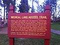
 Medical Lake Access Trail.
 Overlooking the lake (taken from the Access Trail).
References
- 1 2 "US Gazetteer files 2010". United States Census Bureau. Retrieved 2012-12-19.
- 1 2 "American FactFinder". United States Census Bureau. Retrieved 2012-12-19.
- 1 2 "Population Estimates". United States Census Bureau. Retrieved June 19, 2016.
- ↑ "US Board on Geographic Names". United States Geological Survey. 2007-10-25. Retrieved 2008-01-31.
- ↑ Sullivan, Julie (March 16, 1989). "Architect builds historical interest with trivia". Spokane Chronicle. pp. S9. Retrieved 2 May 2015.
- ↑ "US Gazetteer files: 2010, 2000, and 1990". United States Census Bureau. 2011-02-12. Retrieved 2011-04-23.
- ↑ "Annual Estimates of the Resident Population for Incorporated Places: April 1, 2010 to July 1, 2015". Retrieved July 2, 2016.
- ↑ United States Census Bureau. "Census of Population and Housing". Retrieved August 3, 2013.
External links
Municipalities and communities of Spokane County, Washington, United States | ||
|---|---|---|
| Cities | 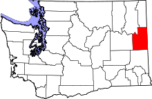 | |
| Towns | ||
| CDPs | ||
| Unincorporated communities | ||
| Ghost towns | ||