Medfield, Massachusetts
| Medfield, Massachusettss | ||
|---|---|---|
| Town | ||
|
Dwight-Derby House (1651) | ||
| ||
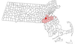 Location in Norfolk County in Massachusetts | ||
| Coordinates: 42°11′15″N 71°18′25″W / 42.18750°N 71.30694°WCoordinates: 42°11′15″N 71°18′25″W / 42.18750°N 71.30694°W | ||
| Country | United States | |
| State | Massachusetts | |
| County | Norfolk | |
| Settled | 1649 | |
| Incorporated | 1651 | |
| Government | ||
| • Type | Open town meeting | |
| Area | ||
| • Total | 14.6 sq mi (37.8 km2) | |
| • Land | 14.5 sq mi (37.6 km2) | |
| • Water | 0.1 sq mi (0.2 km2) | |
| Elevation | 178 ft (54 m) | |
| Population (2010) | ||
| • Total | 12,024 | |
| • Density | 829.2/sq mi (319.8/km2) | |
| Time zone | Eastern (UTC-5) | |
| • Summer (DST) | Eastern (UTC-4) | |
| ZIP code | 02052 | |
| Area code(s) | 508 / 774 | |
| FIPS code | 25-39765 | |
| GNIS feature ID | 0618323 | |
| Website | http://www.town.medfield.net/ | |

Medfield is a town in Norfolk County, Massachusetts, United States. The population was 12,024 according to the 2010 Census. Medfield is an affluent community about 17 miles southwest of Boston, Massachusetts, which is a 45-minute drive to Boston's financial district. Attractions include the Lowell Mason house, Hinkley Pond and the Peak House.
History
The territory that Medfield now occupies was, at the time of colonization, Neponset land. It was apparently sold by the Neponset leader Chickatabot to William Pynchon in the late 1620s. In 1633, however, Chickatabot died in a smallpox epidemic that decimated nearby Neponset, Narragansett and Pequot communities. Because Chickatabot and Pynchon's deal left no written deed, the Massachusetts General Court ordered "those Indians who were present when Chickatabot sold lands to Mr. Pynchon, or who know where they were, to set out the bounds thereof". Fifty years later, Chickatabot's grandson Josias Wampatuck brought a land claim against Medfield and the other towns created within the borders of the Chickatabot purchase, for which he received payment. Of those lands, Dedham was the first town formed.[1]
Dedham was incorporated in 1636, and Medfield (New Dedham) was first settled in 1649, principally by people who relocated from the former town. The first 13 house lots were laid out on June 19, 1650. In May 1651, the town was incorporated by an act of the General Court as the 43rd town in Massachusetts.[2]
The Rev. Ralph Wheelock is credited with the founding of Medfield. He was the first schoolmaster of the town's school established in 1655,[3] and now has an elementary school named after him.

Half the town (32 houses, two mills, many barns and other buildings) was destroyed by Native Americans during King Philip's War in 1675.[3] One house, known as the Peak House, was burnt in the war but was rebuilt shortly thereafter near downtown Medfield.
The town's boundaries originally extended into present-day Medway and Millis. In 1713 the town was divided, with the section west of the Charles River becoming the new town of Medway.[4]
Geography
According to the United States Census Bureau, the town has a total area of 14.6 square miles (37.8 km²), of which 14.5 square miles (37.6 km²) is land and 0.1 square mile (0.2 km²) (0.62%) is water. The Charles River borders almost one-third of Medfield. Medfield is surrounded by the towns Dover, Norfolk, Walpole, Millis, and Sherborn. The Charles River marks the Millis border.
Surrounding communities
Towns that border Medfield.
 |
Sherborn | Dover | | |
| Millis | |
|||
| ||||
| | ||||
| Norfolk | Walpole |
Demographics
| Historical population | ||
|---|---|---|
| Year | Pop. | ±% |
| 1850 | 966 | — |
| 1860 | 1,082 | +12.0% |
| 1870 | 1,142 | +5.5% |
| 1880 | 1,371 | +20.1% |
| 1890 | 1,493 | +8.9% |
| 1900 | 2,926 | +96.0% |
| 1910 | 3,466 | +18.5% |
| 1920 | 3,595 | +3.7% |
| 1930 | 4,066 | +13.1% |
| 1940 | 4,384 | +7.8% |
| 1950 | 4,549 | +3.8% |
| 1960 | 6,021 | +32.4% |
| 1970 | 9,821 | +63.1% |
| 1980 | 10,220 | +4.1% |
| 1990 | 10,531 | +3.0% |
| 2000 | 12,273 | +16.5% |
| 2010 | 12,024 | −2.0% |
| * = population estimate. Source: United States Census records and Population Estimates Program data.[5][6][7][8][9][10][11][12][13][14] | ||
Population and housing
- 12,024 people, 5,284 households, and 5,462 families
- Population density = 326.6 people/km² (845.8 people/sq mi)
- 5,048 housing units
| Race | Population (%) |
|---|---|
| White | 96.78 |
| Black or African American | 0.51 |
| Native American | 0.04 |
| Asian | 1.76 |
| Pacific Islander | 0.01 |
| Other | 0.23 |
| Two or more races | 0.68 |
Hispanic or Latino of any race were 0.90% of the population.
- Of the 5,284 households, 50.0% had children under the age of 18 living with them, 73.8% were married couples living together, 6.4% had a female householder with no husband present, and 18.3% were non-families. 15.5% of all households were made up of individuals and 6.6% had someone living alone who was 65 years of age or older
- Average household size = 3.02
- Average family size = 3.41
Age distribution
- 33.6% under the age of 18
- 3.5% from 18 to 24
- 28.4% from 25 to 44
- 25.2% from 45 to 64
- 9.3% who were 65 or older
- The median age was 38 years.
- For every 100 females there were 96.6 males, and for every 100 females age 18 and over, there were 92.4 males.
Income data
- Per capita income = $62,076
- Median household income = $133,931
- Median family income = $144,263
- About 0.8% of families and 1.4% of the population were below the poverty line, including 1.1% of those under age 18 and 1.6% of those age 65 or over.
Education
Medfield Public Schools consistently ranks among the top ten school systems in Massachusetts by the Massachusetts Comprehensive Assessment System (MCAS).[15] As recently as 2014, Medfield has been ranked by the U.S. News & World Report as the number nine ranked school system in Massachusetts. As of 2013, Medfield High School Seniors scored an average of 591 on the SAT Critical Reading Section, 618 on the SAT Math Section, and 598 on the SAT Writing Section.[16]
In 2005, Medfield High School and T.A. Blake Middle School switched buildings as a result of a massive construction project updating the current Medfield High School (formally T.A. Blake Middle School).
Public schools:
- Memorial School, 59 Adams Street (grades K-1)[17]
- Wheelock School, 17 Elm Street (grades 2–3)[17]
- Dale Street School, 45 Adams Street (grades 4–5)[17]
- Thomas A. Blake Middle School, 24 Pound Street (grades 6–8)[17]
- Medfield High School, 88R South Street (grades 9–12)[17]
Private schools:
- The Montrose School, a Catholic girls' prep. school[18]
Libraries
Medfield's Free Public Library began in 1873.[19] The public library is located on Main Street.[20] In the late 18th century some of the residents of Medfield and surrounding towns formed a subscription library, called the Medfield Social Library.[21]
Events
- On the third Saturday of September, Medfield Employers & Merchants Organization[22] hosts Medfield Day in Medfield Center, which is an annual celebration of the town.
- On the first Friday of December, Medfield Employers & Merchants Organization[23] hosts the annual tree lighting in Baxter Park in Medfield Center.
- On the first Saturday of December, Medfield Employers & Merchants Organization[24] organizes the annual Winter parade which takes place on the streets near Medfield Center.
- On the first Sunday of December, Medfield Foundation[25] hosts the angel run, which is an annual 5k fundraising road race, held to raise money for the Medfield Outreach Program.
Medfield State Hospital
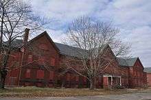
Medfield State Hospital, located at 45 Hospital Road, opened in 1896 and originally operated on 685 acres (2.77 km2) of pasture. At its peak in 1952, it housed 1,500 patients. By 2001, it was down to about 300 acres (1.2 km2) and employed 450 people (including four psychologists) to care for a maximum of 147 patients. The cost to the Commonwealth of Massachusetts was $21.5 million. On April 3, 2003, the doors were closed. Although the buildings are not open to the public (they have been boarded up), the grounds may be visited during daylight hours.
- The film The Box was filmed at the hospital in December 2007.[26]
- The film Shutter Island started prepping February 2008 and started filming at Medfield State Hospital in March 2008.[26]
Points of interest
- Rocky Woods is a 491-acre (1.99 km2) reservation in the northeast part of town. The property has 6.5 miles (10.5 km) of nature trails for hiking or biking, a few ponds for fishing, and open space for picnics and barbecues, and includes Cedar Hill (435 feet (133 m)).[27]
- Noon Hill is a hill in Medfield at 370 feet (110 m) with a trail to its peak. There are a total of 4.5 miles (7.2 km) of trails around the hill and offer views of the hills of Walpole, Norfolk, and Gillette Stadium.[28]
- Peak House. Burnt during the Native-American attack on the town during King Philip's War in 1676, the Peak House was re-built in 1680. It was turned over to the Medfield Historical Society in 1924 and restored to its original Colonial look. It is open every Sunday from 2 PM- 5 PM from June to September and by appointment at other times. It is on the National Register of Historic Places and the steep roof has the highest pitch on record in Massachusetts for a 17th-century house.
- Medfield Historical Society[29] on Pleasant Street. The Society museum contains historic artifacts and documents. The Society also owns the Peak House.
- The Dwight-Derby House: Constructed in 1697. It was long thought that the house was built in 1651, but irrefutable scientific evidence has established that this house was not built until 1697. Still, it is one of only several dozen documented 17th-century houses still standing. Numerous additions have been made to the home over the years as the property changed owners.
- Hinkley Pond, named after Vietnam fatality Stephen Hinkley, a native of Medfield, located on Green Street, is a site for public swimming and has a playground and sand area. Swimming lessons are taught on site.
- Lowell Mason Museum and Music Center. Birthplace of Lowell Mason and a rare example of First Period American architecture and construction. Portions of the house date to 1651 according to a dendrochronology survey.[30] A community effort saved the home from demolition and relocated it to Green Street in April 2011. The Lowell Mason Foundation[31] maintains the house, which will house the Lowell Mason Museum, community space, and a music center.
- Kingsbury Pond, named after Amos Clark Kingsbury (a Medfield native and graduate of Medfield's High School Class of 1916) who served in the United States Marines, American Expeditionary Force, and fought in almost every major battle in France during World War I.[32] Kingsbury Pond is located on Route 27, across the street from St. Edward's Catholic Church. It is a site for public fishing and ice skating. Fishermen have caught very small Largemouth Bass in this pond[33]
- Metacomet Park, named after King Philip (who was also known as Metacomet or Metacom), the chief of the Wampanoag Indians and their leader in the King Philip War.[34] Metacomet Park is an athletic complex and activities area located at 145 Pleasant Street. It offers four tennis courts, a little league baseball diamond, a multi-use field (used for lacrosse, field hockey, and soccer), and a small playground. The park is used for numerous teams to practice and play games.[35]
- Charles River Reservation maintained by the Massachusetts Department of Conservation and Recreation is home to the Bill Martin Flying Field maintained by two clubs, the Millis Model Aircraft Club and the Charles River Radio Controllers.
Notable people
- Hannah Adams (1755–1831), Medfield native and Christian author; the first female professional writer in America
- Uzo Aduba, actress, most recently seen as "Crazy Eyes" on Netflix's Orange Is the New Black, grew up in Medfield.[36]
- Matthew Aucoin, award-winning pianist, conductor/composer with the Metropolitan Opera, Lincoln Center Theater and Chicago Symphony orchestras, opera composer and lyricist.[37]
- Jerry Bergonzi, world-renowned tenor saxophonist, jazz educator, currently holds a full-time professorship at New England Conservatory and is the author of the Inside Improvisation musical book series.
- Donald E. Booth, American Diplomat and current US Ambassador to Ethiopia
- George Inness (1825–1894), artist, some of whose paintings are of Medfield in the nineteenth century. A street in town, near the vantage of one of his paintings, bears his last name.
- Charles Martin Loeffler (1861–1935), a German-born American composer. A street in town off South St. on the development of Southern Acres bears his last name.
- Lowell Mason (1792–1872), a composer of hymns and pioneer of music education in American public schools. A street in town bears his name. His birthplace houses the Lowell Mason Museum and a music center.
- John Preston (1945–1994), author of gay erotica and editor of gay non-fiction anthologies.
- Sports figures
- Raymond Berry, Pro Football Hall of Fame receiver for the Baltimore Colts, former head coach of the New England Patriots
- Drew Bledsoe, retired NFL quarterback, formerly quarterback of the New England Patriots, resided in Medfield when he was the quarterback of the Patriots. He bought the entire Medfield football team cleats before he moved out of Medfield.
- Pete Carroll, coach of the Seattle Seahawks, former coach of USC and the New England Patriots also lived in Medfield. He donated money to keep the high school weight room open all season long during the summer for the football players. Carroll also help start the Middle School football program by getting a $30,000 grant from the NFL.
- Ron Erhardt, former head coach of the New England Patriots lived in Medfield. Ron coached from 1979–1981.
- Rich Gotham, president of the Boston Celtics
- John Hannah, former New England Patriots guard and Hall of Famer.
- Ted Johnson, former linebacker of the New England Patriots lived in Medfield. Ted played for the Patriots from 1995–2004
- Matt Klentak - general manager - Philadelphia Phillies
- Rick Lyle, former defensive end for the New England Patriots lived in Medfield. Rick played for the Patriots from 2002–2003.
- Eric Mangini, former assistant coach for the New England Patriots lived in Medfield. Eric also coached the New York Jets and Cleveland Browns
- Peter McNeeley, boxer. In 1995, Peter McNeeley fought former heavyweight champion Mike Tyson after Tyson's release from prison. The fight lasted a mere 83 seconds.
- Tom McNeeley, boxer who has been KO'd by Floyd Patterson in the 4th round of their fight years before his son Peter's fight with Mike Tyson.
- Randy Moss, former receiver for the New England Patriots lived in Medfield.
- Darrelle Revis, former cornerback for the New England Patriots
- Curt Schilling, of the Boston Red Sox. His family lives on Woodridge Road in a 26-acre (110,000 m2) estate formerly occupied by another athlete, Drew Bledsoe. Schilling bought the home in 2003 for $4,500,001.[38] In 2008 a baseball field, behind the Middle School was dedicated "Curt Schilling Field" and a softball field in the same place was dedicated "Shonda Schilling Field".
References
- ↑ Tilden, W. S. (1887). History of the town of Medfield, Massachusetts, 1650-1886 : with genealogies of the families that held real estate or made any considerable stay in the town during the first two centuries, pp. 21-23. Boston: G. H. Ellis. Quotation from the General Court, qtd. by Tilden.
- ↑ Tilden, W. S. (1884). "Medfield". In D. Hamilton Hurd (Ed.), History of Norfolk County, Massachusetts, pp. 439–41. Philadelphia: J. W. Lewis & Co.
- 1 2 Tilden 1884, p. 442.
- ↑ Tilden 1884, p. 443.
- ↑ "TOTAL POPULATION (P1), 2010 Census Summary File 1". American FactFinder, All County Subdivisions within Massachusetts. United States Census Bureau. 2010.
- ↑ "Massachusetts by Place and County Subdivision - GCT-T1. Population Estimates". United States Census Bureau. Retrieved July 12, 2011.
- ↑ "1990 Census of Population, General Population Characteristics: Massachusetts" (PDF). US Census Bureau. December 1990. Table 76: General Characteristics of Persons, Households, and Families: 1990. 1990 CP-1-23. Retrieved July 12, 2011.
- ↑ "1980 Census of the Population, Number of Inhabitants: Massachusetts" (PDF). US Census Bureau. December 1981. Table 4. Populations of County Subdivisions: 1960 to 1980. PC80-1-A23. Retrieved July 12, 2011.
- ↑ "1950 Census of Population" (PDF). Bureau of the Census. 1952. Section 6, Pages 21-10 and 21-11, Massachusetts Table 6. Population of Counties by Minor Civil Divisions: 1930 to 1950. Retrieved July 12, 2011.
- ↑ "1920 Census of Population" (PDF). Bureau of the Census. Number of Inhabitants, by Counties and Minor Civil Divisions. Pages 21-5 through 21-7. Massachusetts Table 2. Population of Counties by Minor Civil Divisions: 1920, 1910, and 1920. Retrieved July 12, 2011.
- ↑ "1890 Census of the Population" (PDF). Department of the Interior, Census Office. Pages 179 through 182. Massachusetts Table 5. Population of States and Territories by Minor Civil Divisions: 1880 and 1890. Retrieved July 12, 2011.
- ↑ "1870 Census of the Population" (PDF). Department of the Interior, Census Office. 1872. Pages 217 through 220. Table IX. Population of Minor Civil Divisions, &c. Massachusetts. Retrieved July 12, 2011.
- ↑ "1860 Census" (PDF). Department of the Interior, Census Office. 1864. Pages 220 through 226. State of Massachusetts Table No. 3. Populations of Cities, Towns, &c. Retrieved July 12, 2011.
- ↑ "1850 Census" (PDF). Department of the Interior, Census Office. 1854. Pages 338 through 393. Populations of Cities, Towns, &c. Retrieved July 12, 2011.
- ↑ "2011 MCAS Results - Massachusetts Comprehensive Assessment System". Doe.mass.edu. 2011-10-14. Retrieved 2011-10-30.
- ↑ http://www.medfield.net/mhs/attachments/article/38/Guidance%20Profile%202013%202014.pdf
- 1 2 3 4 5 Archived January 11, 2006, at the Wayback Machine.
- ↑ "Montrose School, an independent girls' school for grades 6-12 in Medfield, Massachusetts". Montroseschool.org. Retrieved 2011-10-30.
- ↑ Report of the Free Public Library Commission of Massachusetts, v.9. 1899
- ↑ "medfieldpubliclibrary.org". Medfieldlibrary.org. Retrieved 2011-10-30.
- ↑ Medfield Library [catalog]. Dedham, Mass.: Printed at the Dedham Gazette office, 1816.
- ↑ http://medfieldmemo.org/
- ↑ http://medfieldmemo.org/
- ↑ http://medfieldmemo.org/
- ↑ http://www.medfieldfoundation.org/angelrun.html/
- 1 2 "Film crews visit Medfield State Hospital - Medfield, MA - Medfield Press". Wickedlocal.com. Retrieved 2011-10-30.
- ↑ Rocky Woods (2011-08-15). "Rocky Woods | Medfield, MA | The Trustees of Reservations". Thetrustees.org. Retrieved 2011-10-30.
- ↑ Noon Hill (2011-08-15). "Noon Hill | Medfield, MA | The Trustees of Reservations". Thetrustees.org. Retrieved 2011-10-30.
- ↑ http://www.medfieldhistoricalsociety.org
- ↑ Knapp, Theresa (2010-11-29). "Wicked Local Medfield, "Timber analysis dates Mason house beams to 1600s" Theresa Knapp/correspondent GateHouse News Service (Nov 29, 2010 @ 12:53 pm)". Wickedlocal.com. Retrieved 2011-10-30.
- ↑ http://www.lowellmasonhouse.org
- ↑ Richard DeSorgher (2011-05-07). "The Mystery of Medfield's 'Lady of Route 27' - Medfield, MA Patch". Medfield.patch.com. AOL Inc. Retrieved 2011-10-30.
- ↑ "05/03/09 - Kingsbury Pond - Medfield, MA Details". MA Fish Finder. Retrieved 2011-10-30.
- ↑ "Metacomet - Connexipedia article". Connexions.org. 2010-08-10. Retrieved 2011-10-30.
- ↑ Tremblay, Debbie. "Metacomet Park - Medfield, MA Patch". Medfield.patch.com. Retrieved 2011-10-30.
- ↑ http://www.cosmopolitan.com/celebrity/exclusive/uzo-aduba-gap-tooth
- ↑ Matthew Aucoin
- ↑ "SI.com - MLB - Schilling buying Bledsoe's old home - Monday December 22, 2003 5:37PM". Sportsillustrated.cnn.com. 2003-12-22. Retrieved 2011-10-30.
External links
| Wikivoyage has a travel guide for Medfield. |
| Wikimedia Commons has media related to Medfield, Massachusetts. |
- Medfield Patch - Medfield's online news source since 2010. Published by AOL Inc.
- Medfield.TV
- Town of Medfield
- Medfield Schools
- The Medfield Press-- Medfield's paper since 1922. Published by GateHouse Media of Perinton, New York
- Medfield Weather – current conditions and forecast
Municipalities and communities of Norfolk County, Massachusetts, United States | ||
|---|---|---|
| Cities | 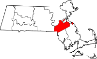 | |
| Towns | ||
| CDPs | ||
| Other village | ||