Medenychi
| Medenychi Меденичі | |||
|---|---|---|---|
| village | |||
|
Main Street of Medenichy | |||
| |||
 Medenychi | |||
| Coordinates: UA 49°25′37″N 23°44′45″E / 49.42694°N 23.74583°ECoordinates: UA 49°25′37″N 23°44′45″E / 49.42694°N 23.74583°E | |||
| Country |
| ||
| Province |
| ||
| District |
| ||
| Established | 1395 | ||
| Area | |||
| • Total | 60,0 km2 (200 sq mi) | ||
| Elevation/(average value of) | 275 m (902 ft) | ||
| Population | |||
| • Total | 3 361 | ||
| • Density | 55,430/km2 (143,600/sq mi) | ||
| Time zone | EET (UTC+2) | ||
| • Summer (DST) | EEST (UTC+3) | ||
| Postal code | 82160, 82161 | ||
| Area code | +380 3244 | ||
| Website | смт Меденичі (Ukrainian) | ||
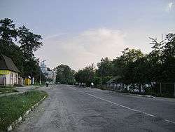

Medenychi (Ukrainian: Меденичі) is an urban-type settlement in Drohobych Raion (district) of Lviv Oblast (region) in Western Ukraine. Population: 3,371 (2013 est.)[1]. Local government is administered by Medenychi village council.[2]
History
The territory was occupied by Germans in early July 1941. Once the territory was occupied by Germans, pogroms against the Jewish community were carried out by locals and continued till spring 1942. In August 1942, most of the Medenychi Jews were sent to the Bełżec extermination camp. According to the Soviet archives and testimonies gathered by Yahad-In Unum, the column of Jews was shot midway between Medenychi and Hirske (Gorkoye). The Jews were shot in small groups in the clay pit, located close to the road. The execution was carried out by Germans.[3]
References
- ↑ "Чисельність наявного населення України (Actual population of Ukraine)" (in Ukrainian). State Statistics Service of Ukraine. Retrieved 21 January 2015.
- ↑ Меденицька селищна (сільська) рада (Ukrainian)
- ↑ http://yahadmap.org/#village/medenychi-lviv-ukraine.625