Mead, Colorado
| Town of Mead, Colorado | |
|---|---|
| Statutory Town | |
|
Main Street in Mead. | |
| Motto: A little town with a big future | |
 Location in Weld County and the state of Colorado | |
| Coordinates: 40°13′29″N 104°59′19″W / 40.22472°N 104.98861°WCoordinates: 40°13′29″N 104°59′19″W / 40.22472°N 104.98861°W | |
| Country |
|
| State |
|
| County[1] | Weld |
| Platted | February 16, 1906 |
| Incorporated (town) | March 17, 1908[2] |
| Government | |
| • Type | Statutory Town[1] |
| Area | |
| • Total | 4.4 sq mi (11.5 km2) |
| • Land | 4.3 sq mi (11.2 km2) |
| • Water | 0.1 sq mi (0.3 km2) |
| Elevation[3] | 5,003 ft (1,525 m) |
| Population (2010) | |
| • Total | 3,405 |
| • Density | 458.4/sq mi (175.4/km2) |
| Time zone | Mountain (MST) (UTC-7) |
| • Summer (DST) | MDT (UTC-6) |
| ZIP code[4] | 80542 |
| Area code(s) | 970 |
| FIPS code | 08-49600 |
| GNIS feature ID | 0202568 |
| Website | Town of Mead |

The Town of Mead is a Statutory Town in Weld County, Colorado, United States. The town population was 3405 at the 2010 United States Census.
History
A post office called Mead has been in operation since 1907.[5] The town was named after Dr. Martin S. Mead, a pioneer settler.[6]
Geography
Mead is located at 40°13′29″N 104°59′19″W / 40.22472°N 104.98861°W (40.224781, -104.988573).[7] It sits approximately 35 miles north of the State Capitol in Denver.
According to the United States Census Bureau, the town has a total area of 4.4 square miles (11 km2), of which, 4.3 square miles (11 km2) of it is land and 0.1 square miles (0.26 km2) of it (2.71%) is water.
Demographics
| Historical population | |||
|---|---|---|---|
| Census | Pop. | %± | |
| 1910 | 114 | — | |
| 1920 | 145 | 27.2% | |
| 1930 | 152 | 4.8% | |
| 1940 | 191 | 25.7% | |
| 1950 | 186 | −2.6% | |
| 1960 | 192 | 3.2% | |
| 1970 | 195 | 1.6% | |
| 1980 | 356 | 82.6% | |
| 1990 | 456 | 28.1% | |
| 2000 | 2,017 | 342.3% | |
| 2010 | 3,405 | 68.8% | |
| Est. 2015 | 4,476 | [8] | 31.5% |
As of the census[10] of 2010, there were 3,405 people, 1,215 housing units (1,164 occupied), and 573 families residing in the town. The population density was 468.2 people per square mile (180.7/km²). There were 663 housing units at an average density of 153.9 per square mile (59.4/km²). The racial makeup of the town was 95.69% White, 0.15% African American, 0.59% Native American, 0.50% Asian, 1.83% from other races, and 1.24% from two or more races. Hispanic or Latino of any race were 6.94% of the population.
There were 641 households out of which 52.4% had children under the age of 18 living with them, 82.2% were married couples living together, 5.0% had a female householder with no husband present, and 10.5% were non-families. 7.5% of all households were made up of individuals and 2.2% had someone living alone who was 65 years of age or older. The average household size was 3.15 and the average family size was 3.31.
In the town the population was spread out with 34.8% under the age of 18, 4.9% from 18 to 24, 35.7% from 25 to 44, 20.3% from 45 to 64, and 4.3% who were 65 years of age or older. The median age was 34 years. For every 100 females there were 101.5 males. For every 100 females age 18 and over, there were 96.7 males.
The median income for a household in the town was $79,298, and the median income for a family was $81,433. Males had a median income of $55,455 versus $32,596 for females. The per capita income for the town was $31,483. About 0.7% of families and 2.0% of the population were below the poverty line, including 2.6% of those under age 18 and 5.2% of those age 65 or over.
In the media
The film Die Hard 2 used locations in Mead for filming including the Highland Lake Church and the surrounding land which served as the base of operations for the villains who take over Dulles International Airport. During filming, the rear of the church was actually used as the front for exterior filming and a false front was built. Interiors of the church were shot on a soundstage.
Also Rachel Crow from The X Factor Season 1, is from Mead, Colorado.
See also
References
- 1 2 "Active Colorado Municipalities". State of Colorado, Department of Local Affairs. Retrieved 2007-09-01.
- ↑ "Colorado Municipal Incorporations". State of Colorado, Department of Personnel & Administration, Colorado State Archives. 2004-12-01. Retrieved 2007-09-02.
- ↑ "US Board on Geographic Names". United States Geological Survey. 2007-10-25. Retrieved 2008-01-31.
- ↑ "ZIP Code Lookup" (JavaScript/HTML). United States Postal Service. Retrieved November 22, 2007.
- ↑ "Post offices". Jim Forte Postal History. Retrieved 1 July 2016.
- ↑ Dawson, John Frank. Place names in Colorado: why 700 communities were so named, 150 of Spanish or Indian origin. Denver, CO: The J. Frank Dawson Publishing Co. p. 34.
- ↑ "US Gazetteer files: 2010, 2000, and 1990". United States Census Bureau. 2011-02-12. Retrieved 2011-04-23.
- ↑ "Annual Estimates of the Resident Population for Incorporated Places: April 1, 2010 to July 1, 2015". Retrieved July 2, 2016.
- ↑ "Census of Population and Housing". Census.gov. Retrieved June 4, 2015.
- ↑ "American FactFinder". United States Census Bureau. Retrieved 2008-01-31.
External links
"Mead Colorado's Weather Station since 1997"
Municipalities and communities of Weld County, Colorado, United States | ||
|---|---|---|
| Cities | 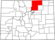 | |
| Towns | ||
| CDP | ||
| Unincorporated communities | ||
| Ghost towns | ||
| Footnotes | ‡This populated place also has portions in an adjacent county or counties | |
