McMillan Sand Filtration Site

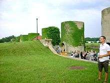
McMillan Sand Filtration Site is a twenty-five acre decommissioned water treatment plant in northwest Washington, D.C., built as part of the historic McMillan Reservoir Park. It is bound on the north by Michigan Avenue, on the east by North Capitol Street, on the south by Channing Street and on the west by McMillan Drive; which runs along the edge of the reservoir, to which it was formerly attached. Two paved courts lined by regulator houses, tower-like sand bins, sand washers and the gated entrances to the underground filter cells provided a promenade for citizens taking the air in the park before it was fenced off in WWII.
Below grade, there are twenty catacomb-like cells, each an acre in extent, where sand was used to filter water from the Potomac River by way of the Washington Aqueduct. The purification system was a slow sand filter design that became obsolete by the late 20th century. In 1985, a new rapid sand filter plant replaced it across First Street beside the reservoir. The treatment system is operated by the Army Corps of Engineers.
Public access to the park has been restricted since World War II, when the Army erected a fence to guard against sabotage of the city's water supply. Until recently, specially arranged biannual tours were arranged for scores of visitors curious about the odd-looking structures. The park was never reopened to the public on the same basis as before the war.
In 1991, the D.C. Historic Preservation Review Board designated McMillan Park a Historic Landmark and nominated the site for the National Register of Historic Places. It included the site on their "List of Most Endangered Properties in 2000"[1] and again in 2005.[2]
History
The 1905 completion of the McMillan Reservoir Sand Filtration Plant was a Washington public health milestone. Its innovative system of water purification, which relied on sand rather than chemicals, led to the elimination of typhoid epidemics and the reduction of many other communicable diseases in the city.[3] A legacy of the City Beautiful Movement and an integral part of the McMillan Plan to modernize Washington, the complex is an engineering wonder that served its original purpose until 1986.
In 1906, Secretary of War William Howard Taft designated the complex as The McMillan Reservoir Park, a memorial to Senator James McMillan (R-Michigan), for his work as chairman of the Senate Commission on the Improvement of the Park System and his efforts in shaping the development of the city at the turn of the 19th century. After Taft became U.S. President, Congress officially designated the site as a park in March 1911.[4]
The park was conceived of as part of "a necklace of emeralds," large permanent reserves of open green space connected by trails that would ring the city. The site’s design and construction involved the leading civil engineers, urban planners, artists and architects including pre-eminent landscape architect of the time: Frederick Law Olmsted, Jr., engineer Allen Hazen, sculptor Herbert Adams and architect Charles Platt.
The site has been described as "an imaginative combination of landscaped park, with promenades, sculpture, curving carriage drives, careful grading and the placement of trees planned and personally supervised by Olmsted. The heirs of Senator McMillan personally financed the landscaping." [5] Crowning the park was a pink granite fountain, designed by Adams and Platt and dedicated in 1913 as a memorial to Senator McMillan. Featuring three nymphs representing faith, hope and charity, the monument was funded by contributions from every Michigan county. The fountain has since been removed.
Residents from the ethnically diverse neighborhoods near the park expressed their "delight in this rigidly segregated city in being able to enjoy its amenities regardless of race. Courting couples promenaded on the geometrically laid out avenues on the east site under a canopy of clipped trees. Families, on hot summer nights, slept in the park to catch the summer breezes that blew over the escarpment. Residents would gather during the evenings for a summer concert series. During World War I the Girl Scouts camped and grew vegetables on the site between North Capitol Street and First Street.[6] Boys played ball games on the east portion where there were fewer manhole covers near Michigan Avenue. They laughed about sometimes falling through the center of a vault to the white sand beneath when a manhole cover had been left open."[7]
During the Corps of Engineers’ ownership, no commercial development of the site occurred. When the National Capital Planning Commission prepared the federal element of its first Comprehensive Plan in 1983, it included McMillan Park as among the "Parks, Open Space and Natural Features" of the city that "should be conserved and whose essential Open Space Character [be] maintained."
The site's future became uncertain, though, in 1986 when the Corps of Engineers declared the property surplus and asked the General Services Administration to dispose of it. GSA iterated its position that open space was not the highest and best use of the property, and insisted on selling the property for mixed commercial development over the objections of the McMillan Park Committee.[8]
The District of Columbia government purchased the site from the federal government in 1987 for $9.3M, in order to facilitate development. Since the time of purchase, the property has remained unused and closed to the public.
Recent developments
The D.C. government is again considering the McMillan Sand Filtration Site for commercial and residential development. The National Capital Revitalization Corporation (NCRC), a development agency created by the city, selected the site as part of a land swap deal involving Anacostia riverfront property and the construction of the Nationals Park baseball stadium. (The government dissolved the NCRC in 2007 and merged its functions into the Office of the Deputy Mayor for Planning and Economic Development.[9])
The government selected a development team, Vision McMillan Partners, in 2007.[10] Their proposal includes a mix of uses, including housing, shopping and office space. The site would also include a network of accessible park space, including 6.25 acres on the southern end of the site, a 1-acre healing garden on the north end, and an acre of green space over a preserved cell at the north end.
The VMP proposal has met with opposition from some neighborhood groups. The team has been meeting with the surrounding neighborhoods since before its selection in 2007 and has included neighborhood input in project revisions. The plan is currently under review by the Historic Preservation Review Board, which will vote on the buildings on the site but not the overall Master Plan for redevelopment.
In 2013, DC Water proposed a plan to use McMillan to provide neighborhood relief of flooding that plagued the Bloomingdale neighborhood, in which the site is situated. The plan calls for the use of two cells to retain water, and to demolish a number of cells in order to provide access to the tunnel they will build on First Street, NW to manage the system.
A group of residents opposed to the development have also launched a petition drive to ask the city to reject the VMP plan and consider alternative proposals.
See also
References
- ↑ DC Preservation League. "List of Most Endangered Properties in 2000." Archived February 28, 2009, at the Wayback Machine.
- ↑ DC Preservation League. "List of Most Endangered Properties in 2005."
- ↑ Scott, Pamela (2007), "Capital Engineers: The U.S. Army Corps of Engineers in the Development of Washington, D.C., 1790-2004." pp. 173-177. Washington, DC: U.S. Army Corps of Engineers. Publication No. EP 870-1-67.
- ↑ Pub.L. 441, 36 Stat. 983, March 2, 1911.
- ↑ Anne Sellin, Historic Designation of McMillan, 1990
- ↑ Among The Girl Scouts, The Washington Post", July 20, 1917
- ↑ Testimony of Anne Sellin re B16-0902, the Transfer of McMillan Park Reservoir to NCRC, October 20, 2006.
- ↑ McMillan Park Committee v. National Capital Planning Commission, 968 F2d 1283 (D.C. Cir. 1992).
- ↑ District of Columbia Government (2007). "District Consolidates Economic Development Agencies." Press release. 2007-07-20.
- ↑ "Mayor Fenty Announces Development Partner for Former McMillan Sand Filtration Site" (Press release). District of Columbia Government. June 13, 2007.
External links
- DC Government Office of Planning McMillan Reservoir Project
- Envision McMillan
- Our McMillan
- Sustainable McMillan
- McMillan Park Reservoir National Historic Listing
Coordinates: 38°55′28.1″N 77°0′37.7″W / 38.924472°N 77.010472°W