McKinley National Park Airport
| McKinley National Park Airport | |||||||||||
|---|---|---|---|---|---|---|---|---|---|---|---|
 | |||||||||||
| IATA: MCL – ICAO: PAIN – FAA LID: INR | |||||||||||
| Summary | |||||||||||
| Airport type | Public | ||||||||||
| Owner | U.S. National Park Service | ||||||||||
| Serves | McKinley Park, Alaska | ||||||||||
| Location | Denali National Park and Preserve | ||||||||||
| Elevation AMSL | 1,720 ft / 524 m | ||||||||||
| Coordinates | 63°43′57″N 148°54′38″W / 63.73250°N 148.91056°W | ||||||||||
| Runways | |||||||||||
| |||||||||||
| Statistics (2005) | |||||||||||
| |||||||||||
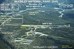
McKinley National Park Airport (IATA: MCL, ICAO: PAIN, FAA LID: INR, formerly 5MK) is a public-use airport located two nautical miles (3.7 km) of McKinley Park,[1] in Denali Borough, Alaska, United States. It is owned by the U.S. National Park Service[1] and is located at the Denali National Park and Preserve (previously Mount McKinley National Park).
Although most U.S. airports use the same three-letter location identifier for the FAA and IATA, this airport is assigned INR by the FAA[1] and MCL by the IATA.[2] The airport's ICAO identifier is PAIN.[3]
Facilities and aircraft
McKinley National Park Airport has one runway designated 16/34 with a gravel surface measuring 3,000 by 68 feet (914 x 21 m). For the 12-month period ending December 31, 2005, the airport had 3,200 aircraft operations, an average of 266 per month: 69% general aviation and 31% air taxi. At that time there were 7 aircraft based at this airport: 57% single-engine, 29% multi-engine and 14% helicopter.[1]
References
- 1 2 3 4 5 FAA Airport Master Record for INR (Form 5010 PDF), effective 2009-07-02.
- ↑ "MCL / PAIN - McKinley Park, Alaska (McKinley National Park Airport)". Great Circle Mapper. Retrieved 2009-08-07.
- ↑ "Alaskan ICAO Identifiers". Federal Aviation Administration. Archived from the original on July 28, 2009. Retrieved 2009-08-07.
External links
- Topographic map from USGS The National Map
- Resources for this airport:
- FAA airport information for INR
- AirNav airport information for PAIN
- ASN accident history for MCL
- FlightAware airport information and live flight tracker
- NOAA/NWS latest weather observations for PAIN
- SkyVector aeronautical chart for INR