Maywood Historic District
|
Maywood Historic District | |
 | |
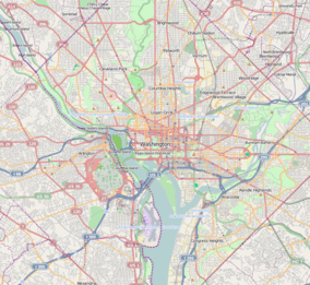   | |
| Location | Roughly bounded by Lorcom Ln., Spout Run Parkway, I-66, Lee Highway, N. Oakland St., N. Nelson St., and N. Lincoln St.Arlington, Virginia |
|---|---|
| Coordinates | 38°53′53″N 77°6′5″W / 38.89806°N 77.10139°WCoordinates: 38°53′53″N 77°6′5″W / 38.89806°N 77.10139°W |
| Area | 46 acres (19 ha) |
| Built | 1906 |
| Architect | Conner, J. Arthur; et al. |
| Architectural style | Late Victorian, Late 19th And 20th Century Revivals |
| NRHP Reference # | 03000460[1] |
| VLR # | 000-5056 |
| Significant dates | |
| Added to NRHP | May 22, 2003 |
| Designated VLR | May 19, 2003, February 7, 2006[2] |
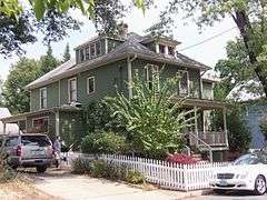
The Maywood Historic District is a national historic district located at Arlington County, Virginia. It contains 198 contributing buildings in a residential neighborhood in North Arlington. The area was platted and subdivided in five sections between 1909 and 1913, and primarily developed between 1909 and 1929. The dwelling styles include a variety of architectural styles, including Queen Anne, Colonial Revival foursquares, Bungalow, and two-story gable-front houses. Several dwellings in the neighborhood have been identified as prefabricated mail-order houses.[3]
It was listed on the National Register of Historic Places in 2003.[1]
References
- 1 2 National Park Service (2010-07-09). "National Register Information System". National Register of Historic Places. National Park Service.
- ↑ "Virginia Landmarks Register". Virginia Department of Historic Resources. Retrieved 2013-05-12.
- ↑ Carrie E. Albee and Laura V. Trieschmann (November 2002). "National Register of Historic Places Inventory/Nomination: Maywood Historic District" (PDF). and Accompanying four photos and Accompanying map


This article is issued from Wikipedia - version of the 11/30/2016. The text is available under the Creative Commons Attribution/Share Alike but additional terms may apply for the media files.