Maxwelton, Queensland
| Maxwelton Queensland | |||||||||||||
|---|---|---|---|---|---|---|---|---|---|---|---|---|---|
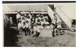 Maxwelton School, date unknown | |||||||||||||
 Maxwelton | |||||||||||||
| Coordinates | 20°43′0″S 142°41′0″E / 20.71667°S 142.68333°ECoordinates: 20°43′0″S 142°41′0″E / 20.71667°S 142.68333°E | ||||||||||||
| Population | 107 (2006 census)[1] | ||||||||||||
| Postcode(s) | 4816 | ||||||||||||
| Location | |||||||||||||
| LGA(s) | Richmond Shire | ||||||||||||
| State electorate(s) | Mount Isa | ||||||||||||
| Federal Division(s) | Kennedy | ||||||||||||
| |||||||||||||
Maxwelton is a small town and locality in the Shire of Richmond in central north Queensland, Australia.[2][3] At the 2006 Census the population of the state suburb of Maxwelton was 107.[1]
Geography
Mazwelton is located on the Flinders Highway 1,625 kilometres from Brisbane by road.
History
Maxwelton was a small railway siding, 50 kilometres (31 mi) west of Richmond now with a population of 3. It derived its name from Maxwelton Station, one of the original pastoral holdings taken up in the 1800s. This station is just south of the rail siding. The site for the township was chosen in 1908, at the junction of the new railway line and the road from McKinlay to the Camp Hotel on the Flinders River. The first sod was turned to begin work on this Great Northern Railway in Townsville in 1879, and by February 1908 it had reached Julia Creek. Before the railway, bullock teams carted wool from Cloncurry to the East Coast, and Cobb and Co stage coaches travelled through with mail in 1871. Several hotels were being built along the Flinders River route, all of which are now in ruins and only recognisable by old stumps or an occasional post here and there. Pastoral holdings were then much larger and in this area, they included Tarbrax, Maxwelton, Clutha and Saxby.[4]
Maxwelton Post Office opened by February 1910 (a receiving office had been open for various periods since 1880) and closed in 1991.[5]
Before the artesian bore was put down in 1929 to a depth of 1,260 feet (384 m), water was carted from the bore at the Talmoi Wool Scour, a couple of miles east of Maxwelton.
Maxwelton is situated on a low flood plain and its biggest flood on record was in 1917. Waters back up for miles, from the Flinders and Alick Creek. A bridge was completed in 1926 called Hulberts Bridge. The Camp Hotel was known locally as the "one-eye" after one of its owners who had one eye, a one eyed horse and a one eyed dog.
In days gone by, the little township has boasted a café, butchers shop, a dance hall, a pub, a post office and a school.
In 1960 the town itself had a population of 72 and the one-teacher school had 17 students from grade 1 to grade 8. The teachers (who boarded at the hotel) at that time were Harry Thomas followed by Henry Crowther (arguably one of the best of outback teachers). Art and dress-making were taught by Mrs Edith Pick (wife of the Postal Clerk) who was also instrumental in organising the annual Maxwelton Gymkhana (Maxwelton Races). The hotel was owned by Mrs Dawson (who had one eye) and was often visited by Cecil Hickmott and his horse 'Dick'. Dick was well known for drinking in the bar and putting on a drunken walk home over the railway line. Apart from the hotel, school, railway station and post office, the only other public building in town was the public shower. Built of corrugated iron next to the bore head and sporting the best shower rose in Australia it was fed by hot water direct from the untapped artesian bore. Also in 1960 the swimming pool was built by locals led by Les Pick (Postal Clerk) and Gilbert Skennerton (Rail Ganger). It was nothing more than an earthen dam with a sand base (trucked from the Flinders River near Hulberts Bridge) but it was a magnet for everyone in town as it was no longer necessary to drive out to the river to cool down in summer.
The main occupants of the town were rail workers who had a row of fettlers cottages along the southern side of the rail track which carried two trains a day - The 44 up to Mt Isa and the 19 down to Townsville (The 44 UP and the 19 DOWN). These trains brought in most supplies. With the road trip to Richmond taking up to one and a half hours each way, the shopping trip to Weekly's store in Richmond was a full day outing. The original Post Office began as a receiving office in 1880. It closed and opened many times firstly in 1885, reopening in 1891 and closing again in 1895. It was again reopened in 1907 when the Chatfield Creek receiving office some twelve miles away closed. It was elevated to a Post Office at the Railway Station in February 1910. It was made official in 1915 then unofficial on 1 September 1970. The Post Office was moved to its later position in 1928.
In 1970 the Post Office was run in conjunction with Telecom as one of the last manual exchanges in Australia. It was at this time reduced to a Post Office Agency. 6 April 1990 saw the Post Office Agency cease and a Community Mail Bag was put into operation.
The Maxwelton School was closed due to lack of children, but has had as many as 35 pupils enrolled in the past. The school first began in the old butchers shop in 1923, and the teacher was given board and lodging at the North Star Hotel for one pound per week. The first official school building was built on five acres of land south of the railway line in 1925 where it still stands today.
For the last 61 years the annual Maxwelton races have occurred at the town's racecourse on the southern side of the Flinders Highway. The future of the race is currently in doubt, but there has been a recent revival in public interest.[6]
The town received national media attention in 1989 when a chemical weapon stockpile was found in the town, similar to the 1,000 pound phosgene bombs found at Embi Airfield.[7]
References
- 1 2 2006 Census QuickStats : Maxwelton (Richmond Shire). Australian Bureau of Statistics. Retrieved on 19 April 2012.
- ↑ "Maxwelton - town (entry 21241)". Queensland Place Names. Queensland Government. Retrieved 13 July 2016.
- ↑ "Maxwelton - locality (entry 42354)". Queensland Place Names. Queensland Government. Retrieved 13 July 2016.
- ↑ From Wyangarie to Richmond A Historic record of the Richmond District of North West Queensland. Compiled by Julie ann Authurs. 1995 Richmond Shire Council ISBN 0 646 25362X. Page 181-186
- ↑ Premier Postal History. "Post Office List". Premier Postal Auctions. Retrieved 10 May 2014.
- ↑ Lisa Kingsberry & Julia Harris (10 June 2011). The last Maxwelton? Not if John Forster has his way. ABC North West Queensland. Australian Broadcasting Corporation. Retrieved on 19 April 2012.
- ↑ David Bromage (2 September 2002). Australia: Chemical weapons. Retrieved on 19 April 2012.