Mawlamyine
| Mawlamyine မော်လမြိုင်မြို့ | |
|---|---|
 | |
 Mawlamyine Location of Mawlamyine, Myanmar (Burma) | |
| Coordinates: 16°29′N 97°37′E / 16.483°N 97.617°E | |
| Country | Burma |
| State | Mon State |
| District | Mawlamyine District |
| Township | Mawlamyine Township |
| Government | |
| Population (2010)[1] | |
| • Total | 325,927 |
| • Ethnicities | Mons, Burmans, Chinese, Indians, Karens |
| • Religions | Theravada Buddhism, Christianity, Islam, Hinduism |
| Time zone | MST (UTC+6.30) |
| Area code(s) | 57 |
| [2] | |
Mawlamyine (also spelled Mawlamyaing; Burmese: မော်လမြိုင်မြို့; MLCTS: mau la. mruing mrui.; pronounced: [mɔ̀ləmjàiɴ mjo̰]; Mon: မတ်မလီု pronounced [mo̤t məlɜ̤m]), formerly Moulmein, is the fourth largest city of Burma (Myanmar),[1] 300 km south east of Yangon and 70 km south of Thaton, at the mouth of Thanlwin (Salween) River. The city of 325,927 is the capital and largest city of Mon State, Myanmar and is the main trading center and seaport in south eastern Burma.[3]
Etymology and legend
The Mon name which was previously used for Mawlamyine, Moulmein (မတ်မလီု; [mòt məlɜ̀m]) means "damaged eye."[4]
It is said to derive from Mot-Mua-Lum, meaning "one eye destroyed". According to legend, a Mon king had a powerful third eye in the centre of his forehead, able to see what was happening in neighbouring kingdoms. The daughter of one of the neighbouring kings was given in marriage to the three-eyed king and managed to destroy the third eye.[5] The Burmese name "Mawlamyine" is believed to be a corruption of the Mon name.
History
Mawlamyine was the first capital of British Burma between 1826 and 1852 after the Tanintharyi (Tenassarim) coast, along with Arakan, was ceded to Britain under the Treaty of Yandabo at the end of the First Anglo-Burmese War.[6]
Mawlamyine is the setting of George Orwell's famous 1936 memoir Shooting an Elephant. The essay opens with the striking words:
- "In Moulmein, in Lower Burma, I was hated by large numbers of people—the only time in my life that I have been important enough for this to happen to me."
During colonial times, Moulmein had a substantial Anglo-Burmese population. An area of the city was known as "Little England" due to the large Anglo-Burmese community, many of them running rubber plantations This has since dwindled to a handful of families as most have left for the UK or Australia.
It is probably best known to English speakers through the opening lines of Rudyard Kipling's poem Mandalay:
- "By the old Moulmein pagoda, lookin' lazy at the sea
- There's a Burma girl a-settin', and I know she thinks o' me".
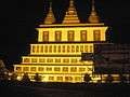
"The old Moulmein pagoda" - Kyaik than lan
The "old Moulmein pagoda" Kipling cites is thought to be the Kyaik than lan (also spelled Kyaikthanlan) pagoda in Mawlamyine.[7] It stands on a ridge, giving a panoramic view of the city, and is surrounded by 34 smaller temples.[7] Among its sacred treasures is a hair relic of Buddha,[7][8] received from a hermit in Thaton,[9] as well as a tooth relic conveyed from Sri Lanka by a delegation of monks.[9]
Built in 875 CE during the reign of King Mutpi Raja,[8] it was raised from its original height of 56 feet to the present 150 feet by successive kings including Anawrahta, founder of the Bagan Dynasty.[8] (Anawrahta is also credited with the construction of the Shwedagon Pagoda in 1056 AD.[10])
Win Sein reclining Buddha at Mudon
29 km south of Mawlamyine is the world's largest reclining Buddha at Mudon. It is approached by a roadway with 500 life size statues of Arahant disciples of Buddha and a hall whose chamber walls display scenes of Buddha's lifetime, and the underworld.[9]
Geography

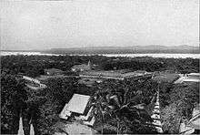
Mawlamyine is in the Salween River delta, where the mouth of the Salween is sheltered by Bilugyun Island as it enters the Gulf of Martaban and the Andaman Sea. It is flanked by low hills dotted with ancient pagodas to the east and west.[6]
Transport

Mawlamyine is the main gateway to south eastern Myanmar. Thanlwin Bridge, the longest road and rail bridge in Myanmar is the most prominent landmark in the area. It stretches 11,000 feet over the Thanlwin River connecting the country's south eastern region with Yangon.[11] The city is connected to Pa-an in Kayin State and Dawei and Myeik in Tanintharyi Division by road.[12] It was the rail head to Ye, linked to Yangon by rail only from Mottama (Martaban) across the river by ferry, but today connected by the Thanlwin Bridge (Mawlamyine) opened in April 2006.[6][13][14]
Mawlamyine Airport has regular flights to Yangon.
Economy
Mawlamyine is famous for its tropical fruits[3] and for its cuisine[6] as indicated in the popular Burmese expression, "Mandalay for the speaking, Yangon for the bragging, and Mawlamyine for the eating."
Mawlamyine has several sawmills and rice mills as teak and rice are transported down the Salween. It was once a busy shipbuilding center and remains an important port. The city has a solar-powered plant for extracting salt from seawater and a diesel electric plant.[6]
On the night of 1 December 2008, a fire that started from a floating restaurant destroyed the larger of city's two markets called the lower bazaar.[15]
On 27 May 2009, three bomb explosions in Mawlamyine were blamed on terrorists by the authorities. No casualties were reported.[16]
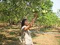
Flora
-
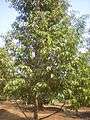
Durian plantation


Culture
Mawlamyine is key to communications in Tanintharyi and, being a busy seaport and transport center, it provides a multicultural dimension despite a Buddhist Mon majority. Buddhist cultural dominance is as old as Mawlamyine, but the British annexation in the 19th century introduced Christianity. St Patrick's School, Mawlamyine (now BEHS-5, Mawlamyine) was opened by the De La Salle Brothers in 1860. Moreover, expansion of trade and commerce in the early 20th century established in Mawlamyine a Hindu culture of India (so-called Galakhar).
Today, the Mon State Cultural Museum is in the city.
Education
Mawlamyine has 13 high schools and a university. The University of Mawlamyine is the major university for the south eastern region and offers bachelor's degrees in most arts and science majors. Students who wish to study medicine, engineering or computer science, or any advanced degree need to go to Yangon. Now,There is Technology University that offers Bachelor of Engineering( B.E) and the university represents Mon State. So,the students who want to study engineering's subjects don't go to Yangon.
The first international student of Bucknell University, Class of 1864, Maung Shaw Loo—born in 1839 in Moulmein—was the first Myanmar medical doctor and native Burmese who studied and was graduated in the United States.[17][18]
Sister cities
Mawlamyine established a Friendship City agreement with Fort Wayne, Indiana, USA in 2016.[19]
Gallery
-

Kyaik Tan Lan pagoda
-

Old bell donated by Mon King
-

Kyaik Soke pagoda
-
Sasana 2500 pagoda
-
Viewpoint pagoda
-
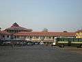
Mawlamyine Coach Station
-
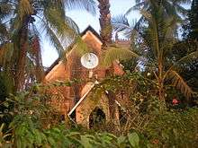
St. Augustine Church
-

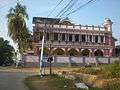
Mawlamyine Railway Station
-
Typical Private hospital in Mawlamyine
-
Thanlwin hotel
-

Thanlwin public park
-

No.1 BEHS Mawlamyine sportshall
-

No.8 BEHS Mawlamyine school building
-
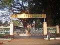
No.7 BEHS Mawlamyine school entrance
See also
- University of Mawlamyine
- Thanlwin Bridge (Mawlamyine)
- Mawlamyine Airport
- Mon people
- Attaran Bridge (Mawlamyine)
- Sittoung Bridge (Bilin)
- (Taung Wine(near University of Mawlamyine))
References
- 1 2 "Myanmar: largest cities and towns and statistics of their population:calculation 2010". Archived from the original on 19 September 2012. World Gazetteer
- ↑ "National Telephone Area Codes". Myanmar Yellow Pages.
- 1 2 "Mawlamyine or Moulmein". allmyanmar.com. Retrieved 2009-02-03.
- ↑ Dictionary of Modern Spoken Mon by H.L. Shorto (1962, Oxford University Press).
- ↑ Myanmar Travel Information. Accessed 16 August 2015
- 1 2 3 4 5 "Moulmein". Encyclopædia Britannica online. Retrieved 2009-02-03.
- 1 2 3 Mawlamyine.com Kyaikthanlan pagoda page Accessed 16 August 2015.
- 1 2 3 Happy Footprints. Accessed 16 August 2015
- 1 2 3 W. Vivian De Thabreuw, Buddhist Monuments and Temples of Myanmar and Thailand (Authorhouse, 11 March 2014). E-book. ISBN 9781491896228.
- ↑ Myanmar Image website. Accessed 16 August 2015
- ↑ "Welcome to Mawlamyine". Retrieved 2008-08-30.
- ↑ "Myanmar (Burma) Maps - Major country roads". Asterism. Retrieved 2009-02-03.
- ↑ "Train travel in Myanmar(Burma)". seat61.com. Retrieved 2009-02-03.
- ↑ "Mon State". Asterism. Retrieved 2009-02-03.
- ↑ Lawi Weng. "Fire Destroys Moulmein Market". The Irrawaddy, December 2, 2008. Retrieved 2009-02-03.
- ↑ "Explosions Shake Parts of Moulmein". The Irrawaddy, May 28, 2009. Retrieved 2009-05-30.
- ↑ "Maung Shaw Loo". Bucknell University. Retrieved 2009-02-03.
- ↑ "Dr. M Shaw Loo" "The Myanmar Net", Myanmar, Retrieved on 30 March 2014
- ↑ "Fort Wayne Sister Cities to sign Myanmar friendship agreement". The News-Sentinel. 26 January 2016. Retrieved 30 March 2016.
External links
| Wikimedia Commons has media related to Mawlamyaing. |
| Wikivoyage has a travel guide for Mawlamyine. |
- Photos of Moulmein
- Mawlamyine
- Weather forecast Weather Underground
- Tide table Mobile Geographics
| Mawlamyine | ||
| Preceded by None |
Capital of British Tenasserim 24 February 1826 – 31 January 1862 |
Succeeded by Yangon |
Coordinates: 16°29′05″N 97°37′33″E / 16.48472°N 97.62583°E
Capital: Mawlamyine | |
|
Capital: Mawlamyine | ||
| Mawlamyine District | 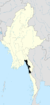 | |
| Thaton District | ||
| Cities and towns | ||