Mautern an der Donau
| Mautern an der Donau | ||
|---|---|---|
 | ||
| ||
 Mautern an der Donau Location within Austria | ||
| Coordinates: 48°23′39.498″N 15°34′36.519″E / 48.39430500°N 15.57681083°ECoordinates: 48°23′39.498″N 15°34′36.519″E / 48.39430500°N 15.57681083°E | ||
| Country | Austria | |
| State | Lower Austria | |
| District | Krems-Land | |
| Government | ||
| • Mayor | Armin Sonnauer | |
| Area | ||
| • Total | 9.14 km2 (3.53 sq mi) | |
| Elevation | 336 m (1,102 ft) | |
| Population (1 January 2016)[1] | ||
| • Total | 3,588 | |
| • Density | 390/km2 (1,000/sq mi) | |
| Time zone | CET (UTC+1) | |
| • Summer (DST) | CEST (UTC+2) | |
| Postal code | 3512 | |
| Area code | 02732 | |
| Website | www.mautern.at | |

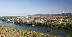
Mautern an der Donau is a town in the district of Krems-Land in the Austrian state of Lower Austria.
Geography
It is situated on the southern bank of the Danube opposite Krems.
History
In former times ships cruising the Danube had to pay a toll when they passed Mautern. The town got its name from there because toll translates as"Maut" in German. Before it got this name it was called Favianae by the Romans because it was a very important fort.
Population
| Historical population | ||
|---|---|---|
| Year | Pop. | ±% |
| 1869 | 1,413 | — |
| 1880 | 1,428 | +1.1% |
| 1890 | 1,493 | +4.6% |
| 1900 | 1,650 | +10.5% |
| 1910 | 1,728 | +4.7% |
| 1923 | 1,643 | −4.9% |
| 1934 | 1,887 | +14.9% |
| 1939 | 1,762 | −6.6% |
| 1951 | 2,118 | +20.2% |
| 1961 | 2,232 | +5.4% |
| 1971 | 2,590 | +16.0% |
| 1981 | 2,883 | +11.3% |
| 1991 | 3,037 | +5.3% |
| 2001 | 3,074 | +1.2% |
| 2011 | 3,447 | +12.1% |
References
- ↑ Statistik Austria - Bevölkerung zu Jahresbeginn 2002-2016 nach Gemeinden (Gebietsstand 1.1.2016) for Mautern an der Donau.
Gallery
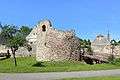 Ruins of the Kastell Favianis in Mautern a.d. Donau
This article is issued from Wikipedia - version of the 5/23/2016. The text is available under the Creative Commons Attribution/Share Alike but additional terms may apply for the media files.