Maunawili, Hawaii
| Maunawili, Hawaii | |
|---|---|
| Census-designated place | |
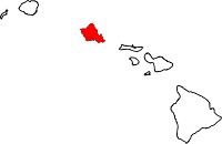
 Location in Honolulu County and the state of Hawaii | |
| Coordinates: 21°22′36″N 157°45′37″W / 21.37667°N 157.76028°WCoordinates: 21°22′36″N 157°45′37″W / 21.37667°N 157.76028°W | |
| Country | United States |
| State | Hawaii |
| Area | |
| • Total | 1.9 sq mi (4.8 km2) |
| • Land | 1.9 sq mi (4.8 km2) |
| • Water | 0.0 sq mi (0.0 km2) |
| Elevation | 69 ft (21 m) |
| Population (2010) | |
| • Total | 2,040 |
| • Density | 1,100/sq mi (430/km2) |
| Time zone | Hawaii-Aleutian (UTC-10) |
| Area code(s) | 808 |
| FIPS code | 15-50750 |
| GNIS feature ID | 0362301 |
Maunawili is a residential census-designated place (CDP) in the City & County of Honolulu, Koʻolaupoko District, Island of Oʻahu, Hawaii, United States. As of the 2010 Census, the CDP had a population of 2,040.[1] Situated mauka (inland or mountain side) of Kalanianaʻole Highway between Castle Junction and Castle Hospital, Maunawili is nearly all private homes, schools, and a few churches; horse stables complete the rural setting. There are no commercial establishments. However, residents are only minutes (by car or bus) from Kailua.

Maunawili Valley extends behind the prominent windward peak known as Olomana. The residential developments extend only part way back into the valley, which is quite large and fairly wet, supporting limited agriculture (mostly banana growing) behind the housing. Water from the numerous streams is diverted by a ditch to much drier Waimānalo to support agricultural activities there.
A golf course and agricultural research station (HSPA) are located in the valley. An attraction of increasing popularity is the Maunawili Demonstration Trail, a state-maintained trail that traverses the breadth of upper Maunawili Valley from the Pali Highway (access at the "Horseshoe Curve") to Waimānalo. A connecting side trail (Maunawili Falls Trail) is accessible from the neighborhood in upper Maunawili.
The U.S. postal code for Maunawili is the same as for Kailua: 96734.
Geography
Maunawili is located at 21°22′36″N 157°45′37″W / 21.37667°N 157.76028°W (21.376650, -157.760166).[2] Lying adjacent to Maunawili is the community of Kailua.
According to the United States Census Bureau, the CDP has a total area of 1.9 square miles (4.8 km2), all land.[3]
Demographics
As of the census[4] of 2000, there were 4,869 people, 1,458 households, and 1,224 families residing in the CDP. The population density was 1,399.0 people per square mile (540.2/km²). There are 1,491 housing units at an average density of 428.4 per square mile (165.4/km²). The racial makeup of the CDP was 36.62% White, 0.55% Black or African American, 0.08% Native American, 28.47% Asian, 8.79% Pacific Islander, 0.55% from other races, and 24.93% from two or more races. 5.79% of the population were Hispanic or Latino of any race.
There were 1,458 households out of which 31.7% had children under the age of 18 living with them, 68.7% were married couples living together, 11.1% had a female householder with no husband present, and 16.0% were non-families. 11.1% of all households were made up of individuals and 5.8% had someone living alone who is 65 years of age or older. The average household size was 3.10 and the average family size 3.31.
In the CDP the population was spread out with 23.0% under the age of 18, 6.1% from 18 to 24, 27.7% from 25 to 44, 26.9% from 45 to 64, and 16.2% who were 65 years of age or older. The median age was 41 years. For every 100 females there were 89.2 males. For every 100 females age 18 and over, there were just 83.6 males.
The median income for a household in the CDP was $82,148, and the median income for a family was $84,294. Males had a median income of $51,078 versus $36,324 for females. The per capita income for the CDP was $30,551. 2.5% of the population and 1.5% of families were below the poverty line. Out of the total population, 3.6% of those under the age of 18 and 2.3% of those 65 and older were living below the poverty line.
Government and infrastructure
The Hawaii Department of Public Safety operates the Women's Community Correctional Center in Maunawili.[5][6] The Hawaii Department of Human Services's Hawaii Youth Correctional Facility (HYCF) is located in Maunawili.[6][7]
Education
Hawaii Department of Education operates public schools. Maunawilli Elementary School and Kailua High School are located in Maunawili CDP.[6]
References
- ↑ "Profile of General Population and Housing Characteristics: 2010 Demographic Profile Data (DP-1): Maunawili CDP, Hawaii". U.S. Census Bureau, American Factfinder. Retrieved May 23, 2012.
- ↑ "US Gazetteer files: 2010, 2000, and 1990". United States Census Bureau. 2011-02-12. Retrieved 2011-04-23.
- ↑ "Geographic Identifiers: 2010 Demographic Profile Data (G001): Maunawili CDP, Hawaii". U.S. Census Bureau, American Factfinder. Retrieved May 23, 2012.
- ↑ "American FactFinder". United States Census Bureau. Retrieved 2008-01-31.
- ↑ "Women's Community Correctional Center." Hawaii Department of Public Safety. Retrieved on May 19, 2010.
- 1 2 3 "Maunawili CDP, Hawaii." U.S. Census Bureau. Retrieved on May 21, 2009.
- ↑ "Frequently Called Numbers." Hawaii Department of Public Safety. Retrieved on August 22, 2010. "Hawaii Youth Correctional Facility" "42-477 Kalanianaole Highway Kailua, HI 96734"
Islands, municipalities, and communities of Honolulu County, Hawaii, United States | ||
|---|---|---|
| CDPs |
|  |
| Unincorporated communities | ||