Maule Region
| Maule Region VII Región del Maule | |||
|---|---|---|---|
| Region of Chile | |||
 | |||
| |||
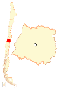
 Map of Maule Region | |||
| Coordinates: 35°26′S 71°40′W / 35.433°S 71.667°WCoordinates: 35°26′S 71°40′W / 35.433°S 71.667°W | |||
| Country |
| ||
| Capital | Talca | ||
| Provinces | Curicó, Talca, Linares, Cauquenes | ||
| Area[1] | |||
| • Total | 30,296.1 km2 (11,697.4 sq mi) | ||
| Area rank | 10 | ||
| Lowest elevation | 0 m (0 ft) | ||
| Population (2012 census)[1] | |||
| • Total | 955,048 | ||
| • Rank | 4 | ||
| • Density | 32/km2 (82/sq mi) | ||
| ISO 3166 code | CL-ML | ||
| Website | Official website (Spanish) | ||

The VII Maule Region (Spanish: VII Región del Maule, pronounced: [ˈmaw.le]) is one of Chile's 15 first order administrative divisions. Its capital is Talca. The region derives its name from the Maule River which, running westward from the Andes, bisects the region and spans a basin of about 20,600 km2. The Maule river is of considerable historic interest because, among other reasons, it marked the southern limits of the Inca Empire.
Geography and ecology

The region covers an area of 30,296 km2 (11,697 sq mi) and is bordered on the west by the Pacific Ocean; on the east by the Argentine Republic; on the north by the O'Higgins Region, and on the south by the Bío-Bío Region. There are a number of flora and fauna species present in Maule. For example, the endangered Chilean Wine Palm (Jubaea chilensis) is found in a very limited distribution that includes the Maule Region.[2] The limited distribution Nothofagus allesandri is also found in the region.[3]
Demography
According to the 2002 census the population of the region was 908,097. With one third of its population living in rural areas, Maule has a greater proportion of rural inhabitants than any other region of Chile.
Population
According to 2009 estimates by the Chilean National Service of Statistics (INE), the Maule Region has a population of 1,050,000 inhabitants. Its most populated city is the regional capital, Talca, with 235,000 inhabitants, followed by Curicó (120,700) and Linares (127,000). Other important cities are: Constitución (50,914), Parral (47,000), Cauquenes (43,000), Molina (42,000), San Javier (40,000).
Population density
The average density of the Maule Region is 32 inhabitants per km2, with less dense areas towards the mountains, and dense areas in the central valley.
Composition by age and sex
According to the composition pyramid of the population of the Region, those younger than fifteen years old are becoming greater in number than the adult population. The annual growth rate of the population of the Maule Region is 1.06%; this comparatively low figure arises from the low birth rate in the Region. The average life expectancy in the Region is 76.3 years.
Economy
Forestry and agriculture, led by wine grape plantations, are the main economic activities. The Maule region is Chile’s leading wine-making region, producing 50% of all the country’s fine export wines, and a number of the largest vineyards are located here. Owing to its high concentration of vineyards, the Curicó valley, which means "black water" in Mapudungun – is considered the core of Chile’s wine industry. Wine-making is a traditional activity, some vineyards dating back to 1830. The increased wine-growing area is matched by the development of the industry’s infrastructure, technology, and equipment.
In addition to wine, two export-oriented agricultural items have emerged dynamically: fruit, vegetables and flowers.
Electricity, gas and water are the second most important economic activity. The Maule River feeds five hydroelectric power plants, including the Colbún-Machicura complex.
Political divisions
The 4 provinces of the Maule Region are divided into 30 communes.
| Political and administrative divisions of Maule Region, Chile |
 |
| Province | Area in km2 | Population | Capital | Communes |
|---|---|---|---|---|
| Cauquenes | 3,027 | 57,088 | Cauquenes | |
| Curicó | 7,281 | 244,053 | Curicó | |
| Linares | 10,050 | 253,990 | Linares |
|
| Talca | 9,961 | 352,966 | Talca |
|
History
Heritage
The Maule Region has produced a remarkable number of famous men and women, in particular writers and poets but also, statesmen and presidents, scientists and naturalists, churchmen, musicians and folklorists, journalists and historians. Thus, the Maule river, the long and wide artery that runs through the region, has been considered Chile's literary river par excellence. Many novels and short stories have had the river as their main background or protagonist. Several anthologies, author's dictionaries and essays have given their account of the cultural wealth of the region.
The region boasts of many small towns and villages with well-preserved colonial rural architecture, both in the religious as well as the civil fields. The Talca and Linares dioceses (the two Roman Catholic dioceses in the Maule region) have several parish churches of particular beauty and architectural and historic value.
Settlement
From the beginning of the colonialization of Chile in the 1550s to until the 1860s, Spanish settlement of the Maule region was minor and small-scale, and only the Chilean army had to defeat the Mapuche Indians in the Arauco War in order to open the new land for white and mestizo settlers from the north. The Basque legacy is well-noted in the descendants' high participation in civil leadership, economics and culture of the Maule region. Maule's culture is tied to agricultural, mountainous and maritime industries.
Also the government in the late 19th century introduced a land settlement program for Spanish and a small number of European immigrants from Austria, France, Germany, Ireland, Italy, Poland, Russia, Switzerland, the United Kingdom or Great Britain, and former Yugoslavia; and smaller contributions from Denmark, Greece, Hungary, the Netherlands, Portugal and the United States with a failed 1880's Cherokee Indian farm colony in Teno adjacent to the Biobio region.
27 February 2010 earthquake and aftermath
At 03:34 local time (06:34 UTC), an 8.8 magnitude earthquake occurred off the Maule coast approximately 11 km (7 mi) southwest of Curanipe and 100 km (62 mi) north-northeast of Chile's second largest city, Concepción.[4] The earthquake lasted nearly four minutes,[5][6] severely affected the region through its action and the resultant tsunami. Cauquenes was damaged by the earthquake.[7] Constitución was damaged by the earthquake and subsequent tsunami. Restoring power in both cities in the immediate aftermath was impossible because of damage from the tsunami.[7]
Politics
Regional Intendant (Intendente)
- Rodrigo Galilea Vial
Provincial Governors
- Curicó Province: Gloria Rojas
- Talca Province: María Elena Villagrán
- Linares Province: Luis Suazo
- Cauquenes Province: María Angélica Sáez
Members of Parliament (Diputados)
The Maule Region is divided into five parliamentary districts. Each one of these returns two members of parliament or deputies.
The table shows the district number, the municipalities encompassed in each district and the names (and party) of the respective members of parliament.
| District number | Municipalities encompassed in the district | Members of Parliament (Political party) |
|---|---|---|
| 36 | Curicó, Teno, Romeral, Molina, Sagrada Familia, Hualañé, Licantén, Vichuquén, Rauco | Roberto León (PDC), Celso Morales (UDI) |
| 37 | Talca | Germán Verdugo (RN), Sergio Aguiló (PS) |
| 38 | Curepto, Constitución, Empedrado, Pencahue, Maule, San Clemente, Pelarco, Río Claro, San Rafael | Pablo Lorenzini (PDC), Pedro Pablo Álvarez-Salamanca (RN) |
| 39 | Linares, Colbún, San Javier, Villa Alegre, Yerbas Buenas | Romilio Gutiérrez (UDI), Jorge Tarud (PPD) |
| 40 | Longaví, Retiro, Parral, Cauquenes, Pelluhue, Chanco | Guillermo Ceroni (PPD), Ignacio Urrutia (UDI) |
Senators (Senadores)
The Maule Region is divided into two senatorial circumscriptions. One (Circumscription North) is composed of the provinces of Curicó and Talca and the other by the provinces of Linares and Cauquenes. Thus, senatorial circumscription North encompasses parliamentary districts 36, 37 and 38, and senatorial circumscription South encompasses parliamentary districts 39 and 40. Each circumscription elects two senators.
The table shows the circumscription name, the municipalities encompassed in each district and the names (and party) of the respective senators.
| Circumscription number and name | Municipalities encompassed in the Circumscription | Members of Parliament (Political party) |
|---|---|---|
| (10) Región del Maule (Norte) | Curicó, Teno, Romeral, Molina, Sagrada Familia, Hualañé, Licantén, Vichuquén, Rauco, Talca, Curepto, Constitución, Empedrado, Pencahue, Maule, San Clemente, Pelarco, Río Claro, San Rafael | Andrés Zaldívar (PDC), Juan Antonio Coloma Correa (UDI) |
| (11) Región del Maule (Sur) | Linares, Colbún, San Javier, Villa Alegre, Yerbas Buenas, Longaví, Retiro, Parral, Cauquenes, Pelluhue, Chanco | Ximena Rincón (PDC), Hernán Larraín (UDI) |
Gallery
 Cathedral San Ambrosio, Linares.
 Bride's Veil Waterfall, in Molina.
 Thermal baths in Panimávida.
 Talca's main commercial street.
 Parish church of the village of Nirivilo.
See also
References
Citations
- 1 2 "Maule Region". Government of Chile Foreign Investment Committee. Retrieved 13 March 2010.
- ↑ C. Michael Hogan (2008)
- ↑ Julian Evans. 2001
- ↑ "Magnitude 8.8 – Offshore Maule, Chile". United States Geological Survey. February 27, 2010. Archived from the original on March 16, 2011. Retrieved February 27, 2010.
- ↑ "USGS Earthquake Details". United States Geological Survey. Archived from the original on March 1, 2010. Retrieved February 27, 2010.
- ↑ Patrick Sawer (February 27, 2010). "Huge earthquake hits Chile". The Daily Telegraph. Retrieved February 27, 2010.
- 1 2 Cowley, Matthew (2 March 2010). "Chile Power Firms: Slow Process Restoring Power In Quake Zones". Wall Street Journal. Retrieved 3 March 2010.
Sources
- C. Michael Hogan (2008) Chilean Wine Palm: Jubaea chilensis, GlobalTwitcher.com, ed. Nicklas Stromberg
- Julian Evans. 2001. The Forests Handbook: Applying forest science for sustainable management. 816 pages
External links
- Gobierno Regional del Maule Official website (Spanish)