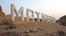
Matmata, Tunisia
Matmata (Arabic: مطماطة ![]() maṭmāṭa) is a small Berber speaking town in southern Tunisia. Some of the local Berber residents live in traditional underground "troglodyte" structures. In 2004 it had a population of 2,116.[1]
maṭmāṭa) is a small Berber speaking town in southern Tunisia. Some of the local Berber residents live in traditional underground "troglodyte" structures. In 2004 it had a population of 2,116.[1]
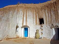
The structures typical for the village are created by digging a large pit in the ground. Around the perimeter of this pit artificial caves are then dug to be used as rooms, with some homes comprising multiple pits, connected by trench-like passageways.
History
It was not generally known until 1967 that there were regular settlements in this area besides wandering nomadic tribes.
That year, intensive rains that lasted for 22 days inundated the troglodyte homes and caused many of them to collapse. In order to get help from the authorities, a delegation was sent to the community center of the region in the town of Gabès. The visit came as a surprise, but help was provided, and the above-ground settlement of Matmâta was built. However, most of the people continued their lives in re-built underground homes, and only a few of the families moved to the new surface dwellings.
Today, Matmata is a popular tourist attraction, and most of the population lives on tourism and folklore exhibitions in their homes.
In popular culture

- The Hotel Sidi Driss in Matmata was used in 1976 as a filming location for Star Wars Episode IV: A New Hope, in which it featured as the home of Luke Skywalker, his Aunt Beru Lars and Uncle Owen Lars on the planet Tatooine. The hotel is designed as a traditional Berber troglodyte underground building. It was featured again in the 2002 prequel film Star Wars: Episode II – Attack of the Clones.[2][3]
- Two of Call of Duty: Finest Hour's missions take place on the outskirts of Matmata, one involving destroying a radio mast, and another a German fuel depot.
- One of Call of Duty 2's missions and multiplayer maps takes place in Matmâta as part of North African Campaign.
- Film La soif noire, an adaptation of the book from Swiss author Hans Ruesch starring Antonio Banderas and Freida Pinto.[4]

References
- ↑ "Recensement de 2004 (Institut national de la statistique)". Ins.nat.tn. Retrieved 2013-09-01.
- ↑ Carvin, Andy (25 January 2006). "The real Star Wars?". ASAP. Associated Press. Retrieved 22 March 2012.
- ↑ Daniel Jacobs and Peter Morris (2001). "Jedi Stomping Ground". Tunisia (6th ed.). London: Rough Guides. p. 319. ISBN 9781858287485.
- ↑ "Matmata accueille bientôt une grosse production" (in French). La Presse de Tunisie. September 24, 2010.
External links
| Look up troglodyte in Wiktionary, the free dictionary. |
| Wikimedia Commons has media related to Matmata. |
- A travel report from Matmata
- The Real Star Wars? - Associated Press article, videos and photo gallery about Matmata by Andy Carvin
- Matmata has many of the best examples of troglodyte architecture in the world.
- Visitors' guide to Hotel Sidi Driss
Coordinates: 33°32′33.5″N 09°58′0.5″E / 33.542639°N 9.966806°E