Matelica
| Matelica | ||
|---|---|---|
| Comune | ||
| Comune di Matelica | ||
|
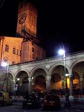
Piazza Enrico Mattei | ||
| ||
 Matelica Location of Matelica in Italy | ||
| Coordinates: 43°15′23.71″N 13°0′34.54″E / 43.2565861°N 13.0095944°ECoordinates: 43°15′23.71″N 13°0′34.54″E / 43.2565861°N 13.0095944°E | ||
| Country | Italy | |
| Region | Marche | |
| Province / Metropolitan city | Province of Macerata (MC) | |
| Frazioni | Balzani, Braccano, Castiglione, Cavalieri, Colferraio, Collepere, Colli, Grimaldi, Mistriano, Pezze, Piane, Poggeto, San Nicola, Terricoli, Valbona, Vinano | |
| Area | ||
| • Total | 81.04 km2 (31.29 sq mi) | |
| Elevation | 354 m (1,161 ft) | |
| Population (Dec. 2013) | ||
| • Total | 10,129 | |
| • Density | 120/km2 (320/sq mi) | |
| Demonym(s) | Matelicesi | |
| Time zone | CET (UTC+1) | |
| • Summer (DST) | CEST (UTC+2) | |
| Postal code | 62024 | |
| Dialing code | 0737 | |
| Patron saint | Sant'Adriano | |
| Saint day | September 16th | |
| Website | Official website | |


Matelica is a comune (municipality) of the Province of Macerata in the Italian region of Marche. Located about 60 kilometres (37 mi) southwest of Ancona and 35 kilometres (22 mi) west of Macerata, it extends over an area of 81.04 square kilometres (31.29 sq mi) [1] and has a population of 10,129 inhabitants (as of 31 December 2013).[1]
Introduction
Matelica lies in an ample valley where the Braccano creek joins the Esino river, dominated by the town from an eastern ravine. The valley, roughly in the north–south direction, is delimited on the east and west sides by Apennines’ sub-ranges, whose highest peaks are respectively Mount Gemmo at 719 metres (2,359 ft) and Mount San Vicino at 1,479 metres (4,852 ft), compared to the 354 metres (1,161 ft) above sea-level of the city centre. The old part of town presents a relatively well-preserved urban structure dating largely from the Middle Ages, and is punctuated by several monumental palazzi and churches from different periods. The local Piersanti Museum hosts a rich collection of artworks. Matelica borders on the following municipalities: Apiro, Castelraimondo, Cerreto d'Esi, Esanatoglia, Fabriano, Fiuminata, Gagliole, Poggio San Vicino, San Severino Marche.[2]
 Governor's palace (under restoration, 2010). |
 View of Matelica and the Esino valley from southwest in wintertime.
The highest mountain in the background (partially engulfed in the clouds) is Mount San Vicino. |
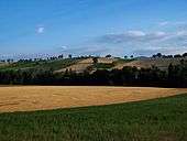 Typical countryside landscape nearby Grimaldi hamlet in summertime. The highest mountain in the far background is Mount Gemmo. |
Historical background
The first human settlements in the area can be traced to the Umbri and Picentes and date back to the 1st millennium BC. Later, under Roman rule, Matelica became a municipium (70 BC). Starting from the 5th century AD, it was seat of a Bishop, who for a while remained the only authority, after the fall of the Roman Empire. The town was then annexed to the Byzantine Empire (552). Destroyed by Longobards in 578, it was subsequently joined to the bishopric of Camerino.[3] From the 9th century, Matelica was under the indirect rule of the Holy Roman Empire (while belonging formally to the Papal States), then becoming a free municipality in 1160. In 1174, it was again obliterated, this time by the army of Christian I (Archbishop of Mainz). Since then, Matelica remained part of the Papal States (albeit at times under an independent Governor), until the Italian unification (1861), save for the brief Napoleonic occupation.
Demography
Over the last thirty years (1982–2012), the total population of Matelica has remained fairly constant at about 10,300, the decrease in the birth-rate being substantially compensated by the migration from within Italy or abroad and by a greater longevity. The demographic distribution reflects that of Italy, although with a relatively larger proportion of aged people, see the pyramid of population below.
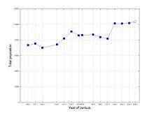 Population of Matelica between 1861 and 2009 (most recent value is estimated).[4] |
 Population pyramid of Matelica by five-year age group (based on residing population as of 1 January 2011).[5] Continuous thick lines represent national values. |
 Historical evolution of the population pyramid of Matelica (by five-year age group) based on residing population between 1982 and 2009.[6] |
Churches
Climate
The climate is dictated by the Apennines and, to a lesser extent, by the temperate Adriatic Sea on the east. Consequently, Matelica enjoys a continental climate with cold winters and hot, dry summers. In winter, sub-zero temperatures and snowfall between December and February are common. Highest summer temperatures can be well above 30 °C (86 °F) in June and August. In keeping with the layout of the valley, the dominant winds are along the north–south direction, those from the south being more frequent but weaker than those from the north.
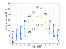 Outside temperature (black dot) in Matelica. Vertical bars indicate average minimum and maximum temperatures; values are monthly averaged and refer to 2009-2011.[7] |
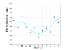 Total precipitations in mm of water (blue dots) in Matelica. Cyan line approximates actual data; values are averaged monthly and refer to 2009-2011.[7] |
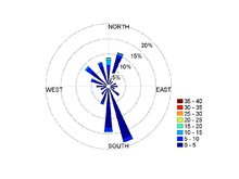
 Maximum (night-time, blue dots) and minimum (day-time, red dots) values of outside humidity in Matelica; lines are curves fit to the data; daily values for the period April 2009 - May 2011.[7] Note the inverse correlation between humidity (or precipitation) and temperature.
|
Curiosities
- Whoever walks or runs seven laps around the fountain in the main square, Piazza Enrico Mattei, under the supervision of an officer of the Pro Matelica, is awarded the "Patente da mattu"(license for a crazy person). This tradition comes from an ancient law of The Ottoni family, which forced all the people who went bankrupt to run 12 laps around the fountain, screaming, "I have given away all my possessions and for this no one should ever believe me again."
- The alley "Orfanelle" in the oldest part of the town is known by most by the name Basciafemmine or Baciafemmine (roughly translated from dialect as "to kiss girls"). The tortuous nature of the alley made it possible for people to go off into a corner with someone without being seen.
- Nicknames have always played an important role in the city, identifying individuals or entire families. The Ottoni clan ruled the city in medieval times. They often did not know the real names of the vicars, only the given nicknames of their families, which meant that it was impossible to be identified by others within the Vatican or back in Lombardy or the Swiss regions. The nicknames were personal, like a barber with an unsteady hand might be called brodolò (coming from "sbrodolare", the Italian verb for dribbling), or for entire families, so people who are nicknamed Bajóccu, will never be Valentinéllu or Masció, despite the same surname.
- The four statues decorating the fountain in the main square, Piazza Enrico Mattei, are positioned in the direction of the four cardinal points and Matelica citizens gave them affectionate nicknames: The Mermaid (North), Maccagnano (East), Biutino (South), and The Fast (West).
References and notes
- 1 2 Demographics: Italian institute of statistics ISTAT
- ↑ Commune-italiani.it. Retrieved June 2, 2010
- ↑ The present cathedral dates from much later: a 15th-century church, it was elevated in 1785, when the bishopric was restored.
- ↑ "comuni-italiani.it". comuni-italiani.it. Retrieved 2011-05-15.
- ↑ "istat.it". istat.it. Retrieved 2012-04-14.
- ↑ "istat.it". istat.it. Retrieved 2011-05-15.
- 1 2 3 4 "vinimaraviglia.com". vinimaraviglia.com. Retrieved 2011-06-07.