Kukenán-tepui
| Kukenán Tepui | |
|---|---|
 Kukenan Tepui | |
| Highest point | |
| Elevation | 2,680 m (8,790 ft) |
| Coordinates | 5°12′36.38″N 60°49′52.18″W / 5.2101056°N 60.8311611°WCoordinates: 5°12′36.38″N 60°49′52.18″W / 5.2101056°N 60.8311611°W |
| Geography | |
 Kukenán Tepui Location of Kukenan Tepui | |
| Location | Venezuela |
| Parent range | Guiana Highlands |
| Geology | |
| Mountain type | Plateau |
| Climbing | |
| Easiest route | Hike |
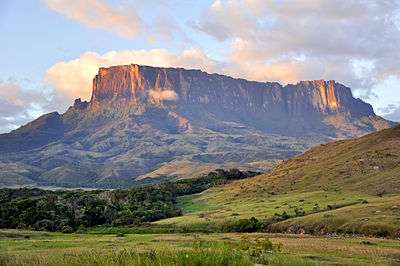
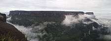
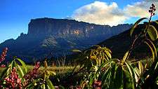
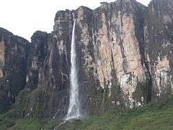
Kukenán, also known as Matawi, is a tepui in Guayana Region, Venezuela. It is 2,680 metres (8,790 ft) high and about 3 km (1.9 mi) long. Kukenan Falls, which is 674 m (2,211 ft) high, is located at the south end of the tepui.[1]
Kukenán is located in Canaima National Park. Next to Kukenán, to the southeast, is Mount Roraima, a better known tepui. Kukenán is more difficult to climb, so it is ascended much less frequently than Mount Roraima.[2]
Scenery on top of Kukenán provided inspiration for the 2009 film Up.
Gallery
| Images of Kukenan Tepui | ||||||
|---|---|---|---|---|---|---|
|
References
- ↑ Kukenaam, Salto. World Waterfall Database.
- ↑ Kukenan Tepui. SummitPost. 24 July 2007.
Further reading
- Kok, P.J.R., R.D. MacCulloch, D.B. Means, K. Roelants, I. Van Bocxlaer & F. Bossuyt (7 August 2012). "Low genetic diversity in tepui summit vertebrates." (PDF). Current Biology 22(15): R589–R590. doi:10.1016/j.cub.2012.06.034 ["supplementary information" (PDF).]
This article is issued from Wikipedia - version of the 11/18/2016. The text is available under the Creative Commons Attribution/Share Alike but additional terms may apply for the media files.