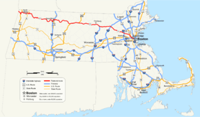
Massachusetts Route 2
| |||||||
|---|---|---|---|---|---|---|---|
 | |||||||
| Route information | |||||||
| Length: | 142.29 mi[1] (228.99 km) | ||||||
| Existed: | 1927, 1971 (current alignment) – present | ||||||
| Major junctions | |||||||
| West end: |
| ||||||
| |||||||
| East end: | Beacon Street in Boston | ||||||
| Location | |||||||
| Counties: | Berkshire, Franklin, Worcester, Middlesex, Suffolk, Norfolk | ||||||
| Highway system | |||||||
| |||||||

Route 2 is a major east–west state highway in Massachusetts. Along with Route 9 and U.S. Route 20 to the south, these highways are the main alternatives to the Massachusetts Turnpike/I-90 toll highway. Route 2 runs the entire length of the northern tier of Massachusetts, beginning at the New York border, where it connects with New York State Route 2, and ending near Boston Common in Boston.
Route description
Route 2 proceeds east from the New York state line on a winding, scenic path in Berkshire County through Williamstown, where it serves the Williams College area and through North Adams, where it serves the Massachusetts College of Liberal Arts. East of North Adams, Route 2 ascends via a hairpin turn into the Hoosac Range along what is known as the Mohawk Trail.
Route 2 then enters Franklin County, meeting Interstate 91 at an interchange in Greenfield and briefly runs concurrently with I-91. While the old Route 2 becomes Route 2A and goes through downtown Greenfield, Route 2 exits off I-91 as a short expressway before becoming a two-lane freeway. Outside Greenfield, Route 2A temporarily ends and merges with Route 2. Route 2 remains a regular two-lane surface road in Gill and through Erving though it has some grade-separated interchanges in Millers Falls at its intersection with Route 63. There is another gap in the two-lane expressway in the Erving area. Recently, the road in Erving was routed to the north and straightened to avoid the paper mill next to the river. This rerouting led to the road being shortened by less than a tenth of a mile.
Once the road enters the Town of Orange, Route 2A resumes and diverges from Route 2. At this point Route 2 again becomes a two-lane expressway. In Orange, Route 2 runs concurrently with U.S. Route 202. The road at this point enters the town of Athol in Worcester County. After its eastern interchange in Phillipston when US 202 departs to the north, Route 2 becomes a full four-lane expressway, though not to Interstate standards at most points. It continues through Gardner into Fitchburg where Route 2 has several at-grade intersections with Oak Hill Road, Palmer Road, Mt. Elam Road and Abbott Avenue. At the intersection with Mt. Elam Road, a traffic light remains in use on the eastbound side. Continuing east into Leominster, Interstate 190 splits off, heading south to Worcester.
Route 2 continues east to Middlesex County and enters Boston's outer loop at the interchange with Interstate 495 in Littleton. It continues as an expressway into Acton, where the expressway ends at the traffic-light intersection with Piper Road and Taylor Road, and Route 2 becomes a regular divided highway at most points and just a four-lane highway at other points. At the Concord Rotary, a major traffic choke point, Route 2 intersects with Route 2A and the eastern terminus of Route 119 (which is concurrent with Route 2A). After the rotary the road loses its dividing wall as it passes by the State Police (who have an emergency-only traffic light) and over the Assabet River. Route 2A formerly broke away from Route 2 at the next traffic light to go left into Concord but is now overlaid with Route 2. At Crosby's Corner, the sixth intersection after the rotary, Route 2A exits under the highway while Route 2 veers right (but still heads east). While the highway is divided across Lincoln, there is a single traffic light intersection at Bedford St.

At this point Route 2 enters Lexington and still is a divided four-lane road with surface intersections. It then heads to Boston's inner belt, crossing Interstate 95/Route 128. In Arlington, Route 2 is a six-lane and then eight-lane limited-access highway until east of Exit 60 (Lake Street), where it narrows with little warning to six lanes and then to four lanes. This section of expressway actually meets the standards of an interstate highway. The final off-ramp leads toward the large parking garage at the MBTA Alewife Station. At this point the road heads into Cambridge.
The limited access highway portion ends at a signaled intersection, where it merges with U.S. Route 3 south and Route 16 west in Cambridge and continues as a four-lane surface road to the Boston Public Garden. Route 2 follows Alewife Brook Parkway, Concord Avenue, Fresh Pond Parkway, Gerry's Landing Road, and Memorial Drive (all parkways maintained by the Department of Conservation and Recreation) through Cambridge. It crosses into Boston on the Boston University Bridge. The Brookline/Norfolk County line also lies upon intersecting Commonwealth Avenue. After crossing Commonwealth Avenue (U.S. Route 20), it follows Mountfort and Beacon streets through the northernmost tip of Brookline before crossing into Kenmore Square, which is the eastern terminus of U.S. Route 20. From Kenmore Square, Route 2 follows Commonwealth Avenue to Arlington Street. It circles the Public Garden, using Arlington Street to Boylston Street to Charles Street. Route 2 goes along northbound Route 28 at the intersection of Charles Street and Beacon Street between Boston Common and the Public Garden. Shortly after, Route 2 ends on U.S. 3 or Route 3 while Route 28 north joins with the southbound of Route 3.
History
The route amalgamates and supersedes various named highways in some cases going back to the pre-automobile era. For example, parts of Route 2 are sometimes known as the Cambridge and Concord Turnpike and the Mohawk Trail.

In the early 1920s, Route 2 was known as New England Interstate Route 7 (NE-7), a major road connecting Boston with Troy, New York. NE-7 ran roughly where Route 2A (the original surface alignment of Route 2) does now except near the New York state line. NE-7 used current Massachusetts Route 43, New York State Route 43 and New York State Route 66 to reach Troy. Current Route 2 from Williamstown to Petersburgh was previously numbered as Route 96.
Route 2 connected as a highway in its current right-of-way at Alewife Brook Parkway at some point before 1937.[2]
An upgraded Route 2 was originally planned to continue as Boston's Northwest Expressway (merging with a re-routed U.S. Route 3 at the Arlington-Lexington or Arlington-Cambridge border) to a junction with Interstate 695, the Inner Beltway, but this, along with the Inner Beltway itself, was cancelled in 1970, accounting for the abrupt narrowing at Alewife.[3][4] In place of the highway project, the MBTA Red Line was extended from Harvard to Alewife in the 1980s.
Crosby's Corner improvement project
This major project has been planned since 1999. The intersection has an average of 90 accidents a year. The project is intended to solve the traffic and safety problems that have occurred at Crosby's Corner intersection (junction of Route 2 and 2A) in Concord. The project, expected to cost $71.9 million, will widen Route 2 from Bedford Road in Lincoln to 300 feet west of Sandy Pond Road in Concord. The project will eliminate the at grade intersection and realign it and construct new entrance and exit ramps along with constructing new service roads next to Route 2. The project was expected to begin in 2011. The state has recently spent $25–35 million for property takings in the path of the new alignment of Route 2. In January 2010 a speeding tanker truck carrying liquid asphalt flipped over on Route 2 and crushed three cars. The truck driver was med-flighted to a Boston hospital with serious injuries. The highway was shut down for five hours causing traffic delays for the 46,000 commuters daily. The accident put the spotlight back on the Crosby's Corner project.
The full project includes building a new overpass bridge over Route 2 and building multiple service roads next to Route 2. Fourteen retaining walls will be built to accommodate the new interchange ramp construction. Work also consists of a new signalized intersection. The project was put out to bid for contractors on September 19, 2011. A contractor was expected to be chosen over the winter and construction was expected to begin in Spring 2012 on the estimated $55 million project.
The Army Corps of Engineers published a notice[5] for this project, because of its impact on wetlands at Crosby's Corner. During the summer of 2012, activity on this portion of Route 2 included surveying and the installation of orange-painted stakes. Signs were added in January 2013 indicating that construction would start on January 14. As of April 2014 the project is underway and predicted completion is Spring 2016.[6]
Concord Rotary Improvement Project
A project to improve the Concord Rotary, at the convergence of Route 2, Route 2A/119, Barrett's Mill Road and Commonwealth Avenue, has been in planning since 2003 or even earlier. More than 61,000 cars use this rotary on a typical day, and the backed up traffic can be significant. The improved intersection would include overpasses for local streets, while Route 2 traffic would continue unimpeded at grade. However, the project was removed from the funded portion of the Boston Region Metropolitan Planning Organization's (MPO) Long Range Transportation Plan (LRTP) in August 2009 and is currently on hold.[7]
Highway improvements
For more information, refer to the Massachusetts Highway Project Listing.[8]
| Completed | Phase | Type | Cost | Location | Project ID | Notes |
|---|---|---|---|---|---|---|
| 2002 | Complete | Median Barrier | $1.6 million | Lincoln | 602308 | Install new Jersey Barrier. |
| 2004 | Complete | Bridge Replacement | $4.3 million | Arlington | 600462 | Replace bridge over Minuteman Bikeway. |
| 2006 | Complete | Reconstruction | $6.7 million | Concord | 602626 | Resurfacing and median replacement of 1.1 miles of highway. |
| 2008 | Complete | Resurfacing | $7.5 Million | Westminster | 604201 | Over Route 140N. |
| 2008 | Complete | Resurfacing | $5.1 Million | Westminster | 604202 | Over Route 140N. |
| 2009 | Complete | Resurfacing | $7.3 Million | Westminster | 604364 | From Exit 26 Easterly |
| 2009 | Complete | Resurfacing | $3.7 million | Lexington | 604638 | Resurface in Lexington |
| 2009 | Complete | Resurfacing | $1.6 million | Lincoln | 604629 | From the Lexington line to Bedford Street in Lincoln. |
| 2009 | Complete | Traffic Signage | $2.1 million | Harvard | 604609 | Replace traffic signs from the Concord Rotary to Exit 38. |
| 2010 | Complete | Traffic Signage | $2.0 million | Lincoln to Cambridge | 604896 | Replace traffic signs from Route 16 to Bedford Road. |
| 2010 | Complete | Resurfacing | $4.0 million | Concord | 604630 | Resurface two sections from Walden to Sudbury and from Nine Acre Corner Rd. to Elm St. |
| 2010 | Complete | Bridge Repair | $1.5 million | Athol | 603582 | Replace the bridge over Lake Rohunta. |
| 2012 | Complete | Resurfacing | $5.5 million | Fitchburg to Leominster | 605722 | Resurface in Fitchburg, Lancaster, and Leominster. |
| 2012 | Complete | Bridge Repair | $17.9 million | Boston | 605506 | Replace deck on the Boston University Bridge over the Charles River. |
| 2012 | Complete | Bridge Repair | $3.4 million | Athol | 604912 | Replace the bridge over White Pond Rd. |
| 2014 | Complete | Bridge Replacement | $13.7 Million | Westminster | 603321 | Replace the Route 2 bridges over Route 140. |
| 2014 | Complete | Resurfacing | $6.8 million | Acton to Littleton | 604472 | Resurface in Acton, Boxborough, and Littleton. |
| 2016 | Complete | Intersection | $1.9 million | Cambridge | 605637 | Rebuild the intersection at Route 16. |
| 2016 | Construction | Intersection | $56.0 million | Concord | 602984 | Safety improvements at Crosby’s Corner. |
| 2017 | Construction | Bridge Replacement | $32.0 million | Lexington | 600703 | Replace the 2 bridges over I-95. |
| TBD | Design | Bridge Replacement | $9.4 million | Concord | 604069 | Replace the existing bridge over the Sudbury River |
| TBD | Design | Intersection | $98.9 million | Concord | 602091 | Replace the Concord rotary with a highway interchange. |
Major intersections
All interchanges along the freeway portions of Route 2 were to be renumbered under a statewide project to change the exits to mileage-based numbers scheduled to start in 2016, however that plan has been placed on hold after negative feedback from both the public, and state officials. [9] [10]
| County | Location[11] | mi[11] | km | Exit[12][13] | Destinations[12][13] | Notes | ||
|---|---|---|---|---|---|---|---|---|
| Berkshire | Williamstown | 0.000 | 0.000 | Continuation from New York | ||||
| 3.824 | 6.154 | Western end of concurrency with US 7 | ||||||
| 6.221 | 10.012 | Eastern end of concurrency with US 7, the beginning of the Mohawk Trail | ||||||
| 6.746 | 10.857 | Northern terminus of Route 43 | ||||||
| North Adams | 11.571 | 18.622 | Western end of concurrency with Route 8 | |||||
| 11.740 | 18.894 | Northern terminus of Route 8A "U" segment | ||||||
| 12.405 | 19.964 | Eastern end of concurrency with Route 8 | ||||||
| Franklin | Charlemont | 29.807 | 47.970 | Western end of concurrency with Route 8A | ||||
| 30.4 | 48.9 | Eastern end of concurrency with Route 8A | ||||||
| Buckland | 37.390 | 60.173 | Western terminus of Route 2A | |||||
| 37.806 | 60.843 | Western end of concurrency with Route 112 | ||||||
| Shelburne | 38.062 | 61.255 | Eastern end of concurrency with Route 112 | |||||
| 38.942 | 62.671 | Western end of concurrency with Route 2A | ||||||
| Greenfield | 47.398 | 76.280 | Western end of concurrency with I-91 and Route 2A; Exit 26 on I-91 | |||||
| 50.139 | 80.691 | Eastern end of concurrency with I-91; Exit 27 on I-91 | ||||||
| 50.789 | 81.737 | Interchange | ||||||
| 51.480 | 82.849 | East end of freeway | ||||||
| 52.242 | 84.075 | Western end of concurrency with Route 2A | ||||||
| Erving | Semb Drive to | |||||||
| 57.404 | 92.383 | Forest Street to | ||||||
| 57.7 | 92.9 | Prospect Street to | ||||||
| 64.865 | 104.390 | Western end of concurrency with Route 2A | ||||||
| 65.060 | 104.704 | West end of Super-2 freeway | ||||||
| Orange | 66.571 | 107.136 | 14 | West River Street – Orange Center | ||||
| 69.788 | 112.313 | 15 | ||||||
| 70.676 | 113.742 | 16 | Western end of concurrency with US 202 | |||||
| Worcester | Athol | 75.155 | 120.950 | 17 | ||||
| Phillipston | 76.474 | 123.073 | 18 | |||||
| 79.009 | 127.153 | 19 | Eastern end of concurrency with US 202; western end of divided freeway | |||||
| Templeton | 81.915 | 131.829 | 20 | Baldwinville Road – Templeton, Baldwinville | ||||
| 83.459 | 134.314 | 21 | ||||||
| Gardner | 86.500 | 139.208 | 22 | |||||
| 87.253 | 140.420 | 23 | Pearson Blvd – South Gardner | |||||
| Westminster | 89.738 | 144.419 | 24 | Western end of concurrency with Route 140; signed as Exits 24A (West Main Street south) and 24B (Route 140 north) westbound | ||||
| 91.764 | 147.680 | 25 | Eastern end of concurrency with Route 140 | |||||
| 92.568 | 148.974 | 26 | Willard Road / Village Inn Road | Eastbound exit only | ||||
| 93.479 | 150.440 | 27 | Narrows Road / Depot Road | |||||
| Fitchburg | 94.495 | 152.075 | 28 | |||||
| 96.279 | 154.946 | Mount Elam Road | Partially at-grade intersection with barrier in the middle of the road | |||||
| Leominster | 98.007 | 157.727 | 30 | Merriam Avenue / South Street | ||||
| 99.269 | 159.758 | 31A | ||||||
| 99.278 | 159.772 | 31B | ||||||
| 100.355 | 161.506 | 32 | ||||||
| 101.125 | 162.745 | 33 | Northern terminus of I-190 | |||||
| Lancaster | 102.429 | 164.843 | 34 | Mechanic Street / Harvard Street | ||||
| 103.497 | 166.562 | 35 | Northern terminus of Route 70 | |||||
| 104.917 | 168.848 | 36 | Shirley Road – Lancaster, Shirley | |||||
| 106.419 | 171.265 | 37 | Jackson Road – Devens, Reserve Forces Training Area | Signed as Exits 37A (no public access) and 37B westbound | ||||
| Harvard | 109.348 | 175.979 | 38A | |||||
| 109.357 | 175.993 | 38B | ||||||
| Middlesex | Littleton | 113.050 | 181.936 | 39 | Taylor Street – Littleton | |||
| 113.285 | 182.315 | 40A | ||||||
| 113.317 | 182.366 | 40B | ||||||
| Boxborough | 115.505 | 185.887 | 41 | Newtown Road – West Acton, Littleton | ||||
| Acton | 117.612 | 189.278 | 42 | |||||
| 118.013 | 189.924 | 43 | Westbound left exit and eastbound entrance; western terminus of concurrency with Route 111 | |||||
| 118.013 | 189.924 | East end of freeway | ||||||
| Concord | 120.465 | 193.870 | Rotary; western end of concurrency with Route 2A; eastern terminus of Routes 111 and 119 | |||||
| 121.691 | 195.843 | |||||||
| 123.901 | 199.399 | Northern terminus of Route 126 | ||||||
| 124.824 | 200.885 | 50 | Partial interchange; eastern end of concurrency with Route 2A | |||||
| Lincoln | 126.256 | 203.189 | Bedford Road to | |||||
| Lexington | 128.135 | 206.213 | West end of freeway | |||||
| 128.504 | 206.807 | 52A | Exits 29A-B on I-95 / Route 128 | |||||
| 128.527 | 206.844 | 52B | ||||||
| 129.010 | 207.621 | 53 | Spring Street – Lexington | No westbound exit | ||||
| 130.002 | 209.218 | 54 | Waltham Street – Lexington, Waltham | Signed as Exits 54A (Waltham) and 54B (Lexington); westbound exits and eastbound entrances | ||||
| 130.894 | 210.653 | 55 | Pleasant Street – Lexington | Eastbound exit and westbound entrance | ||||
| 131.435 | 211.524 | 56 | Winter Street – Belmont | Eastbound signage | ||||
| Westbound signage; southern terminus of Route 4; eastern terminus of Route 225 | ||||||||
| Arlington–Belmont line | 131.990 | 212.417 | 57 | Dow Avenue – Arlington, Belmont | ||||
| Belmont | 132.711 | 213.578 | 58 | Park Avenue – Arlington | ||||
| Belmont–Arlington line | 133.690 | 215.153 | 59 | |||||
| Arlington | 134.130 | 215.861 | 60 | Lake Street – East Arlington | ||||
| 134.649 | 216.697 | – | Eastbound exit only | |||||
| Arlington–Cambridge line | 134.915 | 217.125 | East end of freeway | |||||
| Cambridge | 135.005 | 217.269 | Western end of concurrency with US 3 and Route 16 | |||||
| 136.354 | 219.440 | Eastern end of concurrency with Route 16 | ||||||
| 139.280 | 224.149 | Eastern end of concurrency with US 3 | ||||||
| Charles River | 139.349 | 224.260 | Boston University Bridge | |||||
| Suffolk | Boston | 139.531 | 224.553 | |||||
| Norfolk |
No major junctions | |||||||
| Suffolk | Boston | 140.446 | 226.026 | Kenmore Square; eastern terminus of US 20 | ||||
| 140.881 | 226.726 | Eastern terminus of Route 2A | ||||||
| 141.556 | 227.812 | One-way southbound | ||||||
| 142.35 | 229.09 | Beacon Street | Eastern terminus | |||||
1.000 mi = 1.609 km; 1.000 km = 0.621 mi
| ||||||||
See also
References
| Wikimedia Commons has media related to Massachusetts Route 2. |
- ↑ Executive Office of Transportation, Office of Transportation Planning - 2005 Road Inventory
- ↑ http://www.schlichtman.org/mahighways/bosmap37.gif
- ↑ http://www.brorson.com/maps/BostonHighwayPlan_1965_Detail/BostonHPDetailLevel1.jpg
- ↑ User: BigRock (April 9, 2007). "Boston's Cancelled Highways". Google Maps. Retrieved December 30, 2010.
- ↑ http://www.nae.usace.army.mil/reg/09/2009-01425.pdf
- ↑ http://www.concordma.gov/Pages/ConcordMA_Publicworks/Crosbys_corner
- ↑ "Route 2 Concord Rotary Reconstruction Project".
- ↑ http://www.massdot.state.ma.us/highway/ProjectInfo.aspx
- ↑ http://www.berkshireeagle.com/news/ci_29689438/no-signs-yet-from-massachusetts-exit-conversion-launch
- ↑ Commonwealth of Massachusetts (2015). "COMMBUYS - Bid Solicitation FAP# HSIP-002S(874) Exit Signage Conversion to Milepost-Based Numbering System along Various Interstates, Routes and the Lowell Connector". Retrieved January 6, 2016.
- 1 2 MassDOT Planning Division. "Massachusetts Route Log Application". Massachusetts Department of Transportation. Retrieved January 22, 2015.
- 1 2 Massachusetts Department of Transportation. "Exit Numbers and Names: Route 2 (Orange to I-495)". Retrieved January 22, 2015.
- 1 2 Massachusetts Department of Transportation. "Exit Numbers and Names: Route 2 (I-495 to Cambridge)". Retrieved January 22, 2015.
- ↑ Google Maps (July 2014). "Street View". Google. Retrieved January 27, 2015.
- ↑ Google Maps (September 2011). "Street View". Google. Retrieved January 22, 2015.