Massachusetts Route 70
| ||||
|---|---|---|---|---|
 | ||||
| Route information | ||||
| Length: | 20.78 mi (33.44 km) | |||
| Major junctions | ||||
| South end: |
| |||
|
| ||||
| North end: |
| |||
| Location | ||||
| Counties: | Worcester | |||
| Highway system | ||||
| ||||

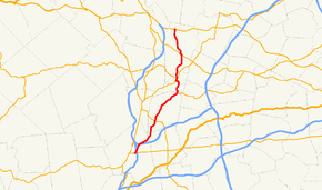
Route 70 is a north–south state highway in Worcester County, Massachusetts.
Route description
Route 70 begins as the northward continuation of Worcester Center Boulevard at Route 9 as Lincoln Street. It crosses under Interstate 290 at Exit 18, a partial exit, and continues northward, bearing northeastward and crossing under Interstate 290 again at Exit 20, another partial exit. It passes several shopping plazas before turning more northward onto Boylston Street. Route 70 passes through the far northwestern corner of Shrewsbury before entering the town of Boylston.
In Boylston, Route 70 crosses Route 140 and proceeds in an arc near the Wachusett Reservoir. As it enters the town of Clinton, Route 70 begins a concurrency with Route 62 which lasts for approximately 2.6 miles (4.2 km), with the last 0.3 miles (0.48 km) being a triple concurrency with Route 110 through the center of town. Once the route leaves the concurrency, it heads northward into the town of Lancaster.
Once in Lancaster, the route passes Atlantic Union College and crosses the north branch of the Nashua River before meeting Route 117, joining the route for a quarter mile. It then turns north again, following the western border of Devens Reserve Forces Training Area (a division of Fort Devens). Route 70 ends just north of Route 2 at Fort Pond Road, where the ramps from Route 2 West's Exit 35.
Junction list
The entire route is in Worcester County.
| Location | mi | km | Destinations | Notes | |
|---|---|---|---|---|---|
| Worcester | 0.0 | 0.0 | Southern terminus of Route 70 at Worcester Center Blvd, Main Street | ||
| 0.3 | 0.48 | I-290 Exit 18 – Westbound exit and eastbound entrance only. | |||
| 1.5 | 2.4 | I-290 Exit 20 | |||
| Boylston | 5.6 | 9.0 | |||
| Clinton | 10.8 | 17.4 | Southern end of concurrency with Route 62. | ||
| 13.0 | 20.9 | Southern end of concurrency with Route 110. | |||
| 13.3 | 21.4 | Northern end of concurrency with Route 110. | |||
| 13.4 | 21.6 | Northern end of concurrency with Route 62. | |||
| Lancaster | 16.9 | 27.2 | Southern end of concurrency with Route 117. | ||
| 17.1 | 27.5 | Northern end of concurrency with Route 117. | |||
| 20.7 | 33.3 | Old Union Turnpike east to Route 2 eastbound access at Exit 35. | |||
| 20.78 | 33.44 | Fort Pond Road east to Route 2 westbound access at Exit 35. Northern terminus of Route 70. | |||
1.000 mi = 1.609 km; 1.000 km = 0.621 mi
| |||||
| Wikimedia Commons has media related to Massachusetts Route 70. |