Qaa
| Qaa القاع El Qaa, Al Qaa | |
|---|---|
 Qaa Location in Lebanon | |
| Coordinates: 34°20′37″N 36°28′32″E / 34.34361°N 36.47556°ECoordinates: 34°20′37″N 36°28′32″E / 34.34361°N 36.47556°E | |
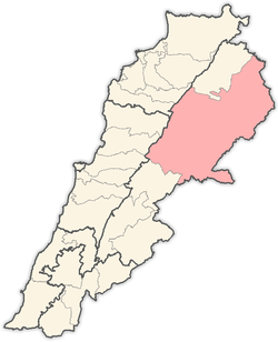
| Country |
|
| Governorate | Beqaa Governorate |
| District | Baalbek District |
| Area | |
| • Total | 4.98 sq mi (12.91 km2) |
| Elevation | 2,156 ft (657 m) |
| Population | |
| • Total | 12,000 |
| • Density | 2,400/sq mi (930/km2) |
| Time zone | EET (UTC+2) |
| • Summer (DST) | +3 (UTC) |
| Alternate name | El Qaa |
|---|---|
| Location | Beqaa Valley, Lebanon |
| Part of | Type site |
| History | |
| Periods | Shepherd Neolithic |
| Site notes | |
| Archaeologists | M. Billaux, Henri Fleisch |
| Condition | ruins |
| Public access | Yes |
Qaa (Arabic: القاع), El Qaa, Al Qaa or Masharih al-Qaa is a town in Beqaa Governorate, Lebanon.[1] It has a mainly Greek Catholic[2] population.
The village has been the target of attacks from Syrian government and anti-government forces.
History
The Syrian army invaded Lebanon at 4am on 1 September 2012 and kidnapped a farmer from the town as part of escalating incursions during the Syrian civil war. The invasion lasted for forty minutes before the unit withdrew. A house in Qaa had previously been hit by a shell fired by the Syrian army.[3]
On the 27th of June 2016, at least five people in Qaa were killed and thirteen others wounded in an attack by four suicide bombers.[4][5]
Archaeology
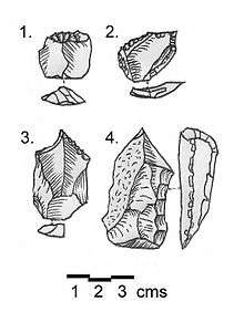
Along with Maqne I, Qaa is a type site of the Shepherd Neolithic industry. The site is located 5 miles (8.0 km) north west of the town, north of a path leading from Qaa to Hermel. It was discovered by M. Billaux and the materials recovered were documented by Henri Fleisch in 1966.[6] The area was lightly cultivated with a thin soil covering the conglomerates. The flints were divided into three groups of a reddish brown, light brown and one that was mostly chocolate and grey colored with a radiant "desert shine".[1]
The Shepherd Neolithic industry can be defined firstly by being small and thick in size, with flakes commonly ranging from 2.5 centimetres (0.98 in) to 4 centimetres (1.6 in), the thickness distinguishing them from geometric microliths. Their second characteristic is the limited number of forms that the tools take, apart from cores being transverse racloirs on small flakes, strong-pointed borers, denticulated or notched thick, short blades and end-scrapers. It was thirdly characterized by a lack of known typology, with only occasional use of Levallois technique. It was determined to be definitely later than the Mesolithic but without any usual forms from the Upper Paleolithic or pottery Neolithic. Henri Fleisch tentatively suggested the industry to be Epipaleolithic and suggested it may have been used by nomadic shepherds.[1] The Shepherd Neolithic has largely been ignored and understudied following the outbreak of the Lebanese civil war.
See also
References
- 1 2 3 L. Copeland; P. Wescombe (1966). Inventory of Stone-Age Sites in Lebanon: North, South and East-Central Lebanon, p. 49. Impr. Catholique. Retrieved 29 August 2011.
- ↑ "Archived copy" (PDF). Archived from the original (PDF) on March 3, 2016. Retrieved May 8, 2015.
- ↑ "Syrian army crosses into Lebanon, snatches farmer". The Daily Star (Lebanon).
- ↑ "Lebanon: Christian village hit by multiple suicide attacks". BBC News. 27 June 2016.
- ↑ "Suicide bombers strike Lebanese village, kill five". 27 June 2016 – via Reuters.
- ↑ Fleisch, Henri., Notes de Préhistoire Libanaise : 1) Ard es Saoude. 2) La Bekaa Nord. 3) Un polissoir en plein air. BSPF, vol. 63, 1966.
External links
Capital: Baalbek | ||
| Towns and villages |
|  |
| Other | ||